

Tino continues to intensify, Signal No. 2 up in 11 areas
Severe Tropical Storm Tino (international name: Kalmaegi) continued to intensify early Monday morning as it moved west southwestward over the Philippine Sea, causing 11 areas in the Visayas and Mindanao be placed under Signal No. 2.
Tropical cyclone wind signals are hoisted over the following areas:
SIGNAL NO. 2
Visayas:
- The central and southern portions of Eastern Samar (Quinapondan, Can-Avid, Guiuan, Lawaan, Balangiga, City of Borongan, Taft, Llorente, Maydolong, Giporlos, Salcedo, Balangkayan, Sulat, San Julian, General Macarthur, Hernani, Mercedes)
- The central and southern portions of Samar (San Sebastian, Santa Rita, Villareal, Zumarraga, Pinabacdao, Talalora, Jiabong, City of Catbalogan, Motiong, Calbiga, Daram, Marabut, Paranas, Basey, Hinabangan)
- Leyte
- Biliran
- Southern Leyte
- Camotes Islands, and
- The eastern portion of Bohol (Talibon, Trinidad, Ubay, Bien Unido, Pres. Carlos P. Garcia, Mabini, Alicia, Candijay, Guindulman, Anda, San Miguel, Pilar, Getafe).
Mindanao
- Dinagat Islands
- Surigao del Norte including Siargao and Bucas Grande Islands
- The northeastern portion of Agusan del Norte (Kitcharao, Jabonga, Santiago, Tubay), and
- The northern portion of Surigao del Sur (Carrascal, Cantilan, Madrid).
SIGNAL NO. 1
Luzon
- Sorsogon
- Masbate including Ticao Island and Burias Island
- The southern portion of Albay (Santo Domingo, Guinobatan, Legazpi City, Camalig, City of Ligao, Rapu-Rapu, Pio Duran, Bacacay, Daraga, Malilipot, Jovellar, Manito)
- Romblon
- The southern portion of Oriental Mindoro (Bansud, Bongabong, Roxas, Mansalay, Bulalacao), and
- The southern portion of Occidental Mindoro (San Jose, Rizal, Calintaan, Magsaysay), and Cuyo Islands.
Visayas
- Northern Samar
- The rest of Eastern Samar
- The rest of Samar
- The rest of Bohol
- The rest of Cebu including Bantayan Islands
- Siquijor
- Negros Oriental
- Negros Occidental
- Guimaras
- Iloilo
- Capiz
- Aklan, and
- Antique including Caluya Islands
Mindanao
- The central portion of Surigao del Sur (Carmen, Lanuza, Cortes, City of Tandag, San Miguel, Tago, Cagwait, Bayabas, Marihatag, San Agustin, Lianga)
- The northern portion of Agusan del Sur (Sibagat, City of Bayugan, Prosperidad, Esperanza)
- The rest of Agusan del Norte
- The eastern portion of Misamis Oriental (Gingoog City, Magsaysay, Medina, Talisayan, Balingoan, Kinoguitan, Claveria, Tagoloan, Villanueva, Jasaan, Balingasag, Lagonglong, Salay, Binuangan, Sugbongcogon), and
- Camiguin.
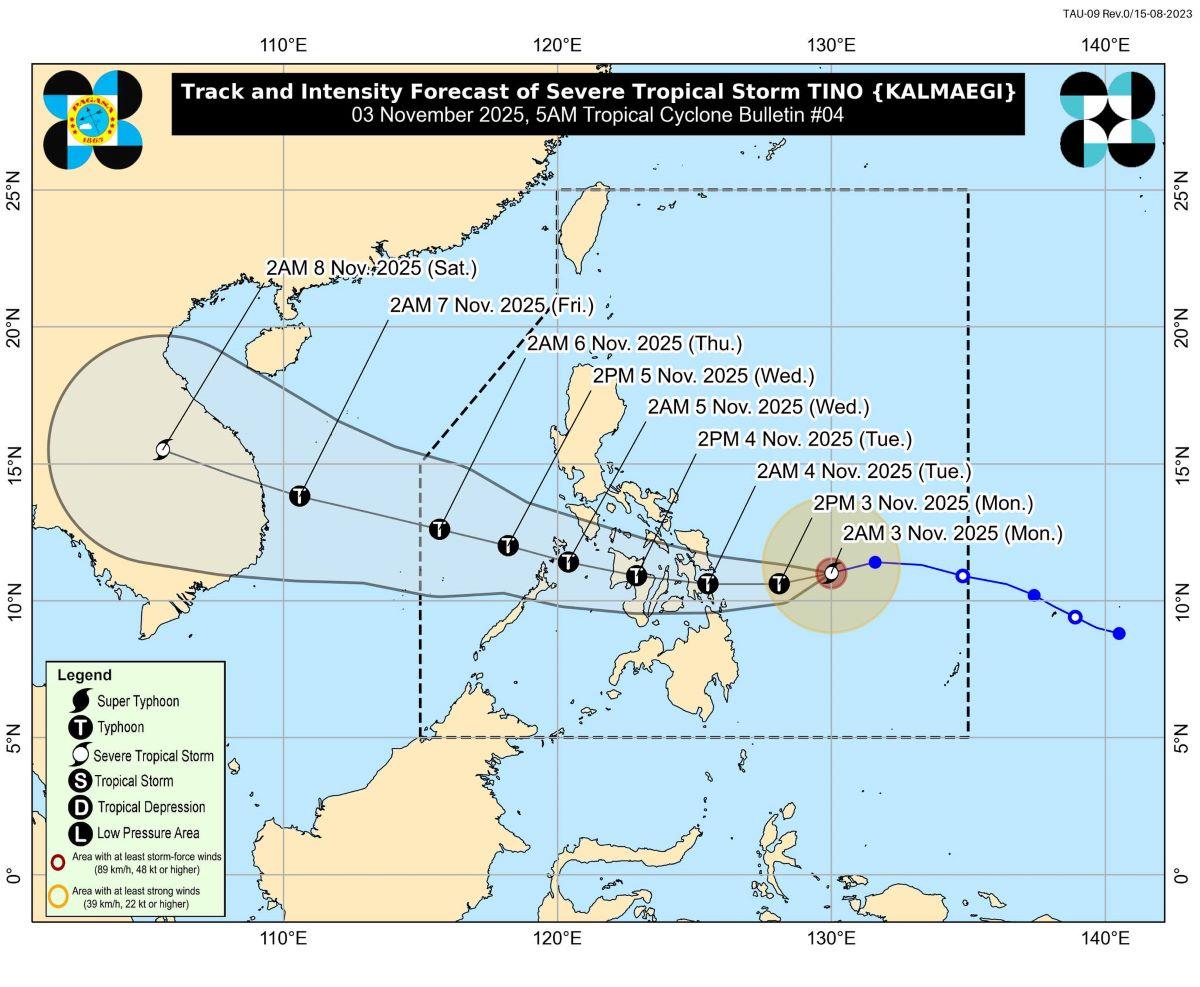
In its 5 a.m. tropical cyclone bulletin for Nov. 3, PAGASA said Tino was last spotted 430 km east of Guiuan, Eastern Samar inside the Philippine Area of Responsibility.
It is moving west southwestward at 30 km/h with maximum sustained winds of 110 km/h near the center and gustiness of up to 135 km/h, bringing stormy weather to Eastern Visayas, Central Visayas, Dinagat Islands, Surigao del Norte, and Surigao del Sur.
It is expected to make its initial landfall over Eastern Samar, Leyte, or Dinagat Island by midnight or early morning of Tuesday, Nov. 4, after which it will traverse Visayas and northern Palawan before exiting the West Philippine Sea on Wednesday morning or afternoon.
PAGASA said Tino may reach typhoon category within the next 12 hours and that “rapid intensification within the next 24 hours is likely.”
It added that it may make its initial landfall at or near peak intensity of around 150 to 165 km/h maximum winds with higher gustiness.
“The possibility of reaching super typhoon category is not ruled out based on alternate scenarios and climatological data. While its interaction with the terrain will trigger a slight weakening, Tino is expected to remain as a typhoon throughout its passage over the country,” PAGASA said.
In an earlier 2 a.m. storm surge warning, PAGASA warned of a “high risk of life-threatening storm surge” in several areas that may occur in the next 48 hours.
“There is a possibility of inundation from rising sea water along with high waves in the low-lying coastal communities,” the state weather bureau said.
Storm surges of more than three meters are expected in Eastern Samar, while storm surges between 2.1 to 3 meters are expected in Dinagat Islands, Eastern Samar, Leyte, Northern Samar, Western Samar, and Surigao del Norte.
Meanwhile, storm surges of up to 1 to 2 meters tall are expected in Agusan del Norte, Aklan, Antique, Biliran, Bohol Camiguin, Capiz, Cebu, Guimaras, Iloilo, Leyte, Masbate, Misamis Oriental, Negros Occidental, Negros Oriental, Northern Samar, Occidental Mindoro, Oriental Mindoro, Palawan, Romblon, Western Samar, Siquijor, Sorsogon, Southern Leyte, Surigao del Norte, and Surigao del Sur.
Classes have been suspended on Monday, Nov. 3 in several parts of Visayas and Mindanao in anticipation of Tino’s impact.
Other weather systems
Meanwhile, the shear line and the Northeast Monsoon (Amihan) are affecting other parts of the country, according to PAGASA.
The shear line is affecting the eastern sections of Northern and Central Luzon, while the Northeast Monsoon is affecting the rest of Northern Luzon.
Isabela, Aurora, and Quezon will experience cloudy skies with scattered rains and isolated thunderstorms as an effect of the shear line.
Cloudy skies and rains are expected over Ilocos Region, Cordillera Administrative Region and the rest of Cagayan Valley due to the northeast monsoon.
Meanwhile, Metro Manila and the rest of the country will have partly cloudy to cloudy skies with isolated rainshowers or thunderstorms as a result of localized thunderstorms. — JMA/KG, GMA Integrated News
