

Signal No. 3 up over parts of Visayas, Mindanao as Tino nears typhoon category
Tropical Cyclone Wind Signal No. 3 was raised over some areas in Visayas and Mindanao on Monday morning as Severe Tropical Storm Tino (international name: Kalmaegi) nears typhoon category, PAGASA said.
TCWS No. 3 was hoisted over:
- the southeastern portion of Eastern Samar (Guiuan, Mercedes); and
- Dinagat Islands and Siargao and Bucas Grande Islands.
Areas under TCWS No. 3 will experience storm-force winds with speeds of 89 to 117 km/h in 18 hours, which may pose moderate to significant threat to life and property.
TCWS No. 2 meanwhile was raised over:
- the central and southern portions of Eastern Samar (Quinapondan, Can-Avid, Lawaan, Balangiga, City of Borongan, Taft, Llorente, Maydolong, Giporlos, Salcedo, Balangkayan, Sulat, San Julian, General Macarthur, Hernani);
- the central and southern portions of Samar (San Sebastian, Santa Rita, Villareal, Zumarraga, Pinabacdao, Talalora, Jiabong, City of Catbalogan, Motiong, Calbiga, Daram, Marabut, Paranas, Basey, Hinabangan);
- Leyte;
- Biliran;
- Southern Leyte;
- Bohol;
- the northern and central portions of Cebu (Pinamungahan, Liloan, Cebu City, Consolacion, Danao City, Borbon, Carmen, Daanbantayan, Tuburan, City of Bogo, Tabogon, Sibonga, City of Naga, Lapu-Lapu City, City of Carcar, Mandaue City, Catmon, Minglanilla, Toledo City, Cordova, Compostela, San Remigio, Balamban, Dumanjug, Aloguinsan, San Fernando, Asturias, Barili, Medellin, Sogod, Tabuelan, City of Talisay) including Bantayan Islands and Camotes Islands;
- the northeastern portion of Negros Occidental (City of Escalante, Toboso, Calatrava, Salvador Benedicto, San Carlos City);
- the rest of Surigao del Norte;
- the northern portion of Surigao del Sur (Carrascal, Cantilan, Madrid, Carmen, Lanuza, Cortes); and
- the northeastern portion of Agusan del Norte (Kitcharao, Jabonga, Santiago, Tubay).
The above-mentioned areas under TCWS No. 2 face gale-force winds in 24 hours which have speeds of 62 to 88 km/h, posing minor to moderate threat to life and property.
TCWS No. 1 on the other hand is in effect over the following:
- Sorsogon;
- Masbate including Ticao and Burias Island;
- Albay;
- the southern portion of Quezon (San Francisco, San Andres);
- the southern portion of Marinduque (Torrijos, Buenavista, Gasan, Boac);
- Romblon;
- the central and southern portions of Oriental Mindoro (Bansud, Bongabong, Roxas, Mansalay, Bulalacao, Gloria, Pinamalayan, Socorro, Pola, Victoria);
- the central and southern portions of Occidental Mindoro (San Jose, Rizal, Calintaan, Magsaysay, Sablayan);
- Cuyo Islands
- Calamian Islands;
- Northern Samar;
- the rest of Eastern Samar;
- the rest of Samar;
- the rest of Cebu;
- Siquijor;
- Negros Oriental;
- the rest of Negros Occidental;
- Guimaras;
- Iloilo;
- Capiz;
- Aklan;
- Antique including Caluya Islands;
- the rest of Surigao del Sur;
- the northern and central portions of Agusan del Sur (Sibagat, City of Bayugan, Prosperidad, Esperanza, San Luis, Talacogon, San Francisco, Rosario);
- the rest of Agusan del Norte, Camiguin, Misamis Oriental; and
- the northern portion of Bukidnon (Baungon, Malitbog, Impasug-Ong, Libona, Manolo Fortich, Sumilao).
Areas under TCWS No. 1 will have strong winds with speeds of 39 to 61 km/h in 36 hours, which may pose minimal to minor threat to life and property.
PAGASA said the highest TCWS that may be raised throughout the passage of Tino is TCWS No. 4.
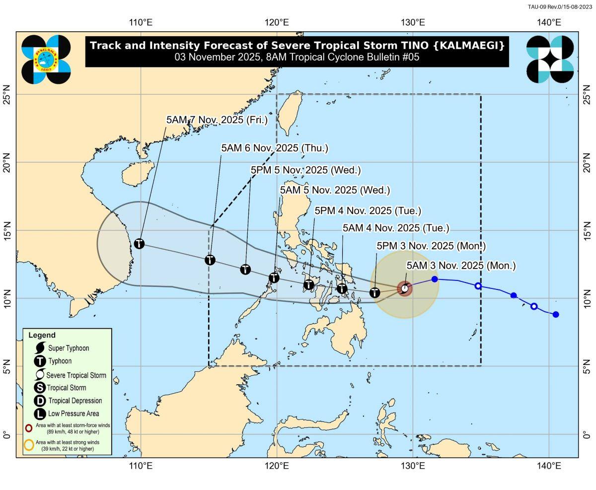
At 7 a.m., the center of Tino was estimated to be located at 360 km east of Guiuan, Eastern Samar.
It has maximum sustained winds of 110 km/h near the center, gustiness of up to 135 km/h, and central pressure of 980 hPa.
Tino is moving west southwestward at 25 km/h.
From its center, strong to storm-force winds are extending outwards up to 300 km.
"On the track forecast, TINO will move generally westward and may make its initial landfall over the vicinity of the southern portion of Eastern Samar, Leyte, Southern Leyte, or Dinagat Islands by midnight or tomorrow (04 November) early morning," PAGASA said.
From there, Tino will then traverse Visayas and northern Palawan, then emerge over the West Philippine Sea on Wednesday morning or afternoon.
Rainfall
Eastern Samar and Dinagat Islands may have more than 200 mm of rainfall today, PAGASA said in its heavy rainfall outlook.
Meanwhile, Surigao del Norte, Southern Leyte, Leyte, Northern Samar, Biliran, and Samar may expect 100 to 200 mm of rainfall.
On the other hand, Sorsogon, Camiguin, Agusan del Norte, Bohol, and Cebu may have 50 to 100 mm of rainfall.
Winds
Strong to gale-force gusts may expected over the following areas not under TCWS, due to the surge of the Northeast Monsoon (Amihan) and the passage of Tino: Cagayan Valley, Cordillera Administrative Region, Ilocos Norte, Aurora, Bulacan, Nueva Ecija, Bataan, Metro Manila, CALABARZON, MIMAROPA, and Bicol Region.
Coastal and upland areas exposed to winds will feel the strong to gale-force gusts more.
Coastal waters
PAGASA raised a gale warning over the eastern seaboards of Visayas and Mindanao, and the eastern and southern seaboards of Southern Luzon.
It also said up to very rough, high or very high seas are forecast for the following coastal areas:
• Up to 9.0 m: The seaboards of the southern portion of Eastern Samar; the eastern seaboards of Leyte and Southern Leyte; the northern and eastern seaboards of Dinagat Islands and Siargao and Bucas Grande Islands.
• Up to 7.0 m: The remaining seaboards of Eastern Samar.
• Up to 5.5 m: The eastern seaboard of Sorsogon; the seaboards of Northern Samar.
• Up to 4.5 m: The eastern seaboard of Camarines Sur; the northern and eastern seaboards of Catanduanes; the eastern seaboard of Albay.
"Sea travel is risky for all types or tonnage of vessels. All mariners must remain in port or, if underway, seek shelter or safe harbor as soon as possible until winds and waves subside," PAGASA said.
Meanwhile, up to rough seas are expected over the following coastal waters:
• Up to 4.0 m: The seaboards of Batanes, Babuyan Islands, Aurora, northern mainland Quezon, Camarines Norte, Surigao del Sur, and northern Cebu; the northern and eastern seaboards of Polillo Islands; the eastern seaboards of mainland Cagayan, Isabela, and Masbate including Ticao and Burias Islands; the remaining seaboards of Albay, Sorsogon, and Eastern Visayas.
• Up to 3.5 m: The remaining seaboards of mainland Cagayan and Ilocos Norte, Surigao del Norte, and Dinagat Islands; the seaboards of Ilocos Sur.
"Mariners of small seacrafts, including all types of motorbancas, are advised not to venture out to sea under these conditions, especially if inexperienced of operating ill-equipped vessels," PAGASA said.
Moderate to rough seas meanwhile will be experienced in the following coastal waters:
• Up to 2.5 m: The remaining seaboard of Catanduanes; the western seaboard of Pangasinan; the eastern seaboard of Davao Oriental; the remaining seaboards of Bicol Region
• Up to 2.0 m: The seaboards of La Union, Northern Mindanao, and Davao Occidental; the eastern seaboard of mainland Quezon; the remaining seaboards of Pangasinan, Central Visayas, and Caraga Region.
"Mariners of motorbancas and similarly sized vessels are advised to take precautionary measures while venturing out to sea and, if possible, avoid navigation under these conditions," PAGASA said.
Track, intensity outlook
PAGASA said Tino's track may still shift "within the limit of the forecast confidence cone."
"TINO is forecast to continuously intensify and may reach typhoon category within the next 12 hours," it said.
Tino may likely rapidly intensify within the next 24 hours, so the possibility of it reaching super typhoon category is nor ruled out, PAGASA said.
It advised the public and disaster risk reduction and management offices to take all necessary measures to protect life and property.
"Persons living in areas identified to be highly or very highly susceptible to these hazards are advised to follow evacuation and other instructions from local officials," the weather bureau said.
The next weather bulletin will be issued at 11 a.m., it added.
Classes
Classes for Monday, November 3, 2025, have been suspended in some areas due to the expected effects of Tropical Storm Tino. —KG, GMA Integrated News
