

Signal No. 3 up over 8 areas as Tino expected to make landfall
Tropical Cyclone Wind Signal No. 3 was raised over eight areas on Monday morning due to Typhoon Tino (international name: Kalmaegi), PAGASA said in its 11 a.m. bulletin.
TCWS No. 3 was hoisted over:
- the southern portion of Eastern Samar (Guiuan, Mercedes, Lawaan, Balangiga, Giporlos, Quinapondan, Salcedo);
- the southern portion of Samar (Marabut);
- the central and southern portions of Leyte (Tanauan, Palo, Tabontabon, Isabel, Merida, Palompon, Ormoc City, Dagami, Pastrana, Burauen, Albuera, Macarthur, La Paz, Mayorga, Dulag, Julita, Tolosa, Abuyog, Javier, City of Baybay, Mahaplag, Inopacan, Hilongos, Hindang, Bato, Matalom);
- Southern Leyte;
- Camotes Islands;
- the eastern portion of Bohol (Pres. Carlos P. Garcia, Bien Unido, Ubay, Trinidad, Talibon, San Miguel, Mabini);
- Dinagat Islands; and
- the northern portion of Surigao del Norte (Surigao City, San Francisco, Tagana-An, Placer, Sison) including Siargao and Bucas Grande Islands.
Areas under TCWS No. 3 will have storm-force winds with speeds of 89 to 117 km/h in 18 hours, posing potential moderate to significant threat to life and property.
TCWS No. 2 meanwhile is in effect over:
- the southern portion of Masbate (Esperanza, Pio V. Corpuz, Placer);
- the central portion of Eastern Samar (Can-Avid, City of Borongan, Taft, Llorente, Maydolong, Balangkayan, Sulat, San Julian, General Macarthur, Hernani);
- the central portion of Samar (San Sebastian, Santa Rita, Villareal, Zumarraga, Pinabacdao, Talalora, Jiabong, City of Catbalogan, Motiong, Calbiga, Daram, Paranas, Basey, Hinabangan, Santo Niño, Almagro, Tarangnan);
- the rest of Leyte;
- Biliran;
- the rest of Bohol;
- the rest of Cebu;
- the northern and central portions of Negros Oriental (Tayasan, Manjuyod, City of Tanjay, Bais City, Mabinay, Bindoy, Ayungon, Jimalalud, City of Guihulngan, La Libertad, Canlaon City, Vallehermoso);
- the northern and central portions of Negros Occidental (City of Escalante, Toboso, Calatrava, Salvador Benedicto, City of Himamaylan, City of Kabankalan, Ilog, Binalbagan, Isabela, Moises Padilla, San Carlos City, La Castellana, Hinigaran, Pontevedra, La Carlota City, San Enrique, Valladolid, Pulupandan, Bago City, Murcia, Bacolod City, City of Talisay, City of Victorias, Enrique B. Magalona, Silay City, Cadiz City, Manapla, Sagay City);
- Guimaras;
- the eastern portion of Capiz (Pilar, President Roxas, Pontevedra, Panay, Dumarao, Cuartero, Ma-Ayon, Panitan, Roxas City, Ivisan, Sigma, Dao, Dumalag);
- the northern and eastern portions Iloilo (Carles, Oton, San Miguel, Cabatuan, Badiangan, Calinog, Bingawan, City of Passi, Dueñas, Mina, Iloilo City, Pavia, Santa Barbara, Zarraga, Pototan, New Lucena, Leganes, Barotac Nuevo, Dumangas, Dingle, San Enrique, Anilao, Banate, Barotac Viejo, San Rafael, Lemery, Ajuy, Concepcion, Sara, San Dionisio, Batad, Balasan, Estancia);
- the rest of Surigao del Norte;
- the northern portion of Surigao del Sur (Carrascal, Cantilan, Madrid, Carmen, Lanuza, Cortes);
- the northeastern portion of Agusan del Norte (Kitcharao, Jabonga, Santiago, Tubay, City of Cabadbaran); and
- the northern portion of Camiguin (Mambajao).
The above mentioned areas under TCWS No. 2 may expect gale-force winds with speeds of 62 to 88 km/h in 24 hours, which may pose minor to moderate threat to life and property.
On the other hand, the following area are under TCWS No. 1:
- Albay;
- Sorsogon;
- the rest of Masbate including Ticao and Burias Island, the southern portion of Quezon (San Francisco, San Andres);
- the southern portion of Marinduque (Torrijos, Buenavista, Gasan, Boac);
- Romblon;
- the central and southern portions of Oriental Mindoro (Bansud, Bongabong, Roxas, Mansalay, Bulalacao, Gloria, Pinamalayan, Socorro, Pola, Victoria);
- the central and southern portions of Occidental Mindoro (San Jose, Rizal, Calintaan, Magsaysay, Sablayan);
- the northern portion of Palawan ( El Nido, Taytay, Dumaran, Araceli, San Vicente, Roxas) including Calamian Islands;
- Cuyo Islands;
- Cagayancillo Islands
- Northern Samar;
- the rest of Eastern Samar;
- the rest of Samar;
- Siquijor;
- the rest of Negros Oriental;
- the rest of Negros Occidental;
- the rest of Iloilo;
- the rest of Capiz;
- Aklan;
- Antique including Caluya Islands;
- the rest of Surigao del Sur;
- the northern and central portions of Agusan del Sur (Sibagat, City of Bayugan, Prosperidad, Esperanza, San Luis, Talacogon, San Francisco, Rosario);
- the rest of Agusan del Norte;
- the rest of Camiguin;
- Misamis Oriental;
- the northern portion of Bukidnon (Baungon, Malitbog, Impasug-Ong, Libona, Manolo Fortich, Sumilao);
- the northern portion of Misamis Occidental (Baliangao, Plaridel, Sapang Dalaga, Calamba, Lopez Jaena); and
- the northern portion of Zamboanga del Norte (Dapitan City, Sibutad, Rizal, Dipolog City).
Areas under TCWS No. 1 may experience strong winds (39 to 61 km/h) in 36 hours, which may pose minimal to minor threat to life and property.
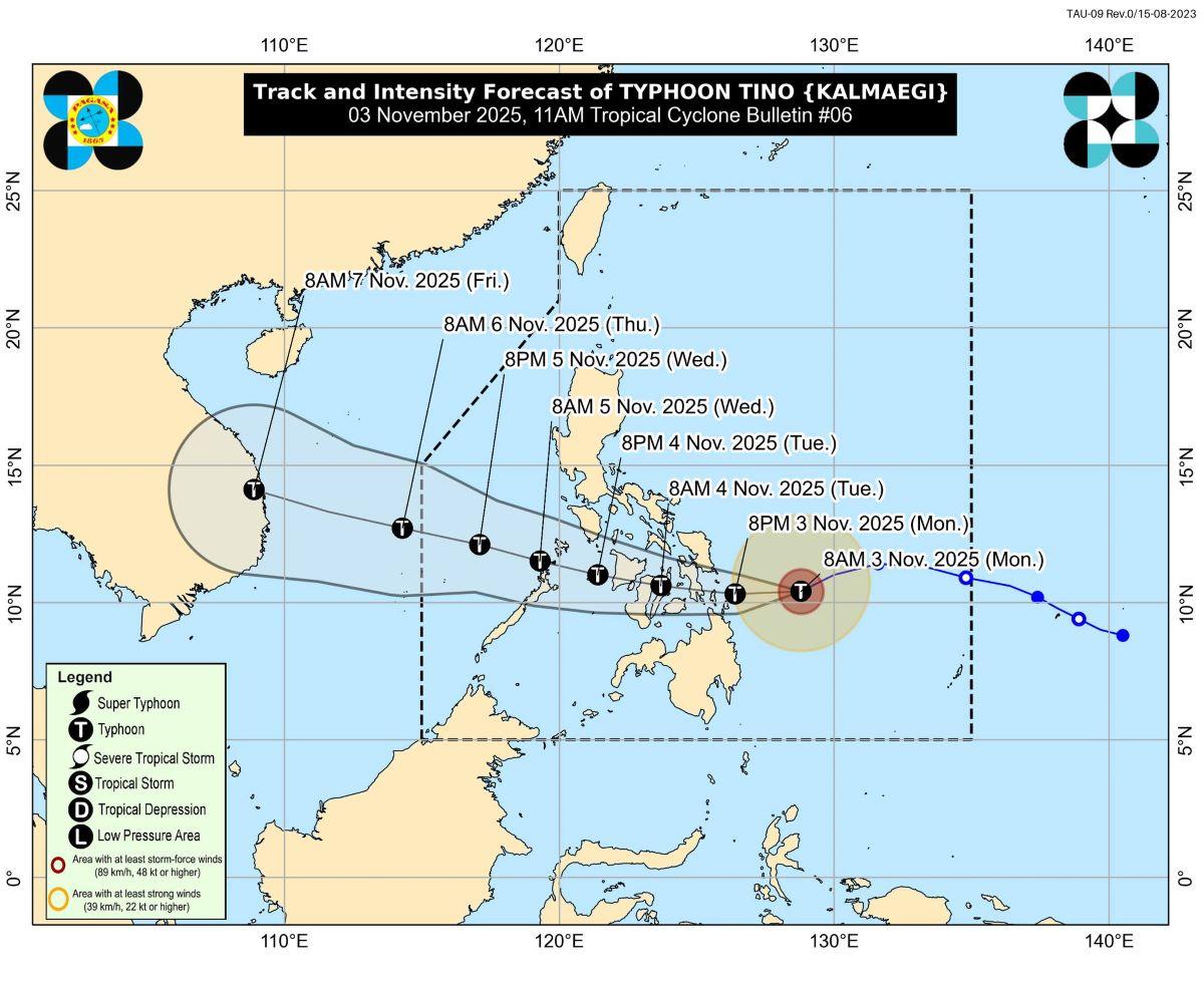
Tino intensified into a typhoon at 8 a.m. on Monday.
At 10 a.m., Tino's center was estimated to be located at 285 km east southeast of Guiuan, Eastern Samar.
The typhoon has maximum sustained winds of 120 km/h near the center, with gustiness of up to 150 km/h, and central pressure of 975 hPa.
Tino is moving west southwestward at 25 km/h.
From its center, strong to typhoon-force winds are extending outwards up to 300 km.
Initial landfall may be over the vicinity of the southern portion of Eastern Samar, Leyte, Southern Leyte, or Dinagat Islands tonight or tomorrow early morning, PAGASA said.
"The highest Wind Signal that will likely be hoisted throughout its passage is Wind Signal No. 4," PAGASA said of Tino.
Rainfall
According to PAGASA's heavy rainfall outlook issued at 11 a.m., from today until Tuesday noon, over 200 mm of rainfall may pour over Eastern Samar, Southern Leyte, Leyte, and Dinagat Islands.
Meanwhile, 100 to 200 mm of rainfall may be expected in Surigao del Norte, Northern Samar, Sorsogon, Biliran, Samar, Cebu, Bohol, Camiguin, and Agusan del Norte.
Some 50 to 100 mm of rain, meanwhile, may be felt in Misamis Oriental, Surigao del Sur, Negros Occidental, Siquijor, Negros Oriental, Iloilo, Capiz, Aklan, Antique, Catanduanes, Romblon, Albay, Masbate, Romblon, Palawan, Marinduque, Oriental Mindoro, Maguindanao del Norte, Maguindanao del Sur, Sultan Kudarat, Misamis Occidental, Zamboanga del Norte, Lanao del Norte, Agusan del Sur, Bukidnon, Sarangani, Lanao del Sur, and Guimaras.
Winds
Meanwhile, Cagayan Valley, Cordillera Administrative Region, Ilocos Norte, Aurora, Bulacan, Nueva Ecija, Bataan, Metro Manila, CALABARZON, MIMAROPA, and Bicol Region will have strong to gale-force gusts today due to the surge of the Northeast Monsoon (Amihan) and the passage of Tino.
Storm surge
"There is a high risk of life-threatening and damaging storm surge with peak heights exceeding 3.0 m within the next 48 hours over the low-lying or exposed coastal communities of Sorsogon, Masbate, Romblon, Oriental Mindoro, Occidental Mindoro, Palawan, Visayas, Dinagat Islands, Surigao del Norte, Surigao del Sur, Agusan del Norte, Misamis Oriental, and Camiguin," PAGASA said.
Gale warning
PAGASA raised a gale warning over the eastern seaboards of Visayas and Mindanao, and the eastern and southern seaboards of Southern Luzon.
The seas will be up to very rough to high over the following coastal waters:
• Up to 9.0 m: The eastern seaboard of Dinagat Islands; the northern and eastern seaboards of Siargao and Bucas Grande Islands.
• Up to 8.0 m: The eastern seaboard of Eastern Samar
• Up to 7.0 m: The remaining seaboard of Eastern Samar; the southern seaboard of Samar; the eastern seaboard of Leyte.
• Up to 6.0 m: The western seaboard of Leyte, the eastern seaboards of northern and central Cebu, the northern seaboard of Bohol.
• Up to 5.0 m: The northern seaboards of Negros Occidental; the eastern seaboards of Northern Samar, northern Iloilo, and Southern Leyte; the southern seaboard of Masbate; the western seaboard of Dinagat Islands.
• Up to 4.5 m: The seaboards of Romblon, Cuyo Islands, and Surigao del Sur; the northern and eastern seaboards of Catanduanes; the northern seaboard of Northern Samar; the eastern seaboards of Albay and Sorsogon; the southern seaboard of Oriental Mindoro; the remaining seaboards of Masbate, Visayas and Caraga Region.
"Sea travel is risky for all types or tonnage of vessels. All mariners must remain in port or, if underway, seek shelter or safe harbor as soon as possible until winds and waves subside," PAGASA said.
Meanwhile, up to rough seas are forecast over the following coastal waters:
• Up to 4.0 m: The seaboards of Batanes, Babuyan Islands, Ilocos Norte, Ilocos Sur, Isabela, Aurora, northern mainland Quezon, and Camarines Norte; the northern and eastern seaboard of Polillo Islands; the northern seaboard of Camarines Sur; the eastern seaboard of mainland Cagayan.
• Up to 3.5 m: The remaining seaboard of mainland Cagayan.
• Up to 3.0 m: The seaboard of La Union, Marinduque, Northern Mindanao, and Davao Oriental; the eastern seaboard of Oriental Mindoro; the western seaboard of Pangasinan; the remaining seaboard of Bicol Region and Quezon.
"Mariners of small seacrafts, including all types of motorbancas, are advised not to venture out to sea under these conditions, especially if inexperienced of operating ill-equipped vessels," PAGASA said.
Up to moderate seas may be expected over:
• Up to 2.5 m: The seaboard of northern Palawan including Calamian Islands and Davao Occidental; the western and southern seaboards of Occidental Mindoro.
• Up to 2.0 m: The seaboard of Zambales and Zamboanga del Norte; the western seaboard of Bataan; the seaboard of Batangas; the remaining seaboards of Pangasinan, Occidental Mindoro, and Oriental Mindoro.
"Mariners of motorbancas and similarly sized vessels are advised to take precautionary measures while venturing out to sea and, if possible, avoid navigation under these conditions," PAGASA said.
Track, intensity
PAGASA said Tino's track "may still shift within the limit of the forecast confidence cone."
After making landfall over the vicinity of the southern portion of Eastern Samar, Leyte, Southern Leyte, or Dinagat Islands tonight or tomorrow, Tino will traverse Visayas and northern Palawan then emerge over the West Philippine Sea on Wednesday afternoon.
The next weather bulletin will be issued at 2 p.m.
Classes
Classes for Monday, November 3, 2025, have been suspended in some areas due to the expected effects of Tino. —KG, GMA Integrated News
