

Signal No. 4 up over 9 areas as Tino threatens Panay Island
Tropical Cyclone Wind Signal No. 4 was raised over nine areas on Tuesday as Typhoon Tino (international name: Kalmaegi) approaches Panay Island, PAGASA said.
TCWS No. 4 was hoisted over the following areas, according to PAGASA's 8 a.m. bulletin:
- the western portion of Leyte (Palompon, Isabel, Merida);
- the northern portion of Cebu (Lapu-Lapu City, Cordova, Mandaue City, Cebu City, Balamban, Asturias, Danao City, Compostela, Liloan, Consolacion, Borbon, Carmen, Tuburan, Catmon, Sogod, Tabuelan, Tabogon, San Remigio, City of Bogo, Toledo City, City of Talisay, Minglanilla, Medellin, Daanbantayan) including Camotes Islands and Bantayan Islands;
- the northernmost portion of Negros Oriental (Vallehermoso, Canlaon City);
- the northern portion of Negros Occidental (San Carlos City, Salvador Benedicto, Calatrava, Toboso, City of Escalante, Sagay City, Cadiz City, Manapla, City of Victorias, Enrique B. Magalona, Silay City, City of Talisay, Bacolod City, Murcia, Bago City, Pulupandan, Valladolid, La Carlota City, San Enrique, Pontevedra, La Castellana);
- Guimaras;
- Capiz;
- Iloilo;
- the central and southern portions of Antique (Patnongon, Sibalom, Barbaza, Valderrama, Hamtic, San Jose, Bugasong, Culasi, Tibiao, Anini-Y, San Remigio, Belison, Tobias Fornier, Laua-An); and
- the southern portion of Aklan (Libacao, New Washington, Banga, Altavas, Madalag, Balete, Batan).
Areas under TCWS No. 4 will have typhoon-force winds with speeds of 118 to 184 km/h in 12 hours, which pose significant to severe threat to life and property.
TCWS No. 3 meanwhile is in effect over:
- the southwestern portion of Masbate (Balud);
- the northernmost portion of Palawan (El Nido, Taytay, Dumaran, Araceli) including Calamian Islands and Cuyo Islands;
- the rest of Leyte;
- Biliran;
- the northern portion of Bohol (Ubay, Pres. Carlos P. Garcia, Trinidad, San Miguel, Bien Unido, Talibon, Getafe, Buenavista, Inabanga, Danao, Dagohoy);
- the central portion of Cebu (Sibonga, City of Carcar, San Fernando, Aloguinsan, Pinamungahan, Barili, Dumanjug, Argao, Alcantara, Moalboal, Ronda, City of Naga);
- the northern portion of Negros Oriental (City of Guihulngan, La Libertad, Jimalalud);
- the central portion of Negros Occidental (Hinigaran, Moises Padilla, Isabela, Binalbagan);
- the rest of Aklan; and
- the rest of Antique including Caluya Islands.
The above-mentioned areas under TCWS No. 3 will have storm-force winds with speeds of 89 to 117 km/h in 18 hours, posing moderate to significant threat to life and property.
TCWS No. 2 on the other hand was raised over:
- the western portion of Masbate (Esperanza, Pio V. Corpuz, Placer, Cawayan, Milagros, Mandaon);
- the southern portion of Oriental Mindoro (Bulalacao, Mansalay, Roxas, Bongabong);
- the southern portion of Occidental Mindoro (Magsaysay, San Jose, Rizal, Calintaan);
- Romblon;
- the northern portion of Palawan (San Vicente, Roxas);
- the western and southern portion of Samar (San Sebastian, Santa Rita, Villareal, Zumarraga, Pinabacdao, Talalora, Jiabong, City of Catbalogan, Motiong, Calbiga, Daram, Paranas, Basey, Hinabangan, Santo Niño, Almagro, Tarangnan, Marabut, San Jorge, Gandara, Pagsanghan, Santa Margarita, Tagapul-An, Calbayog City);
- the rest of Cebu;
- the central portion of Negros Oriental (Tayasan, Manjuyod, Bais City, Mabinay, Bindoy, Ayungon, City of Tanjay, Pamplona, Amlan, San Jose);
- the rest of Negros Occidental;
- Southern Leyte; and
- the rest of Bohol.
These areas will have gale-force winds in 24 hours at speeds of 62 to 88 km/h, which may pose minor to moderate threat to life and property.
The following areas meanwhile are under TCWS No. 1:
- Sorsogon;
- the rest of Masbate including Ticao Island;
- Burias Island;
- Albay;
- the rest of Oriental Mindoro;
- the northern and central portions of Occidental Mindoro (Sablayan, Santa Cruz, Abra de Ilog, Mamburao, Paluan);
- the southern portion of Quezon (San Francisco, San Andres);
- the southern portion of Marinduque (Torrijos, Buenavista, Gasan, Boac);
- the central portions of Palawan (Puerto Princesa City) including Cagayancillo Islands;
- Northern Samar;
- Eastern Samar;
- the rest of Samar;
- the rest of Negros Oriental;
- Siquijor;
- Dinagat Islands;
- the northern portion of Surigao del Norte (Surigao City, San Francisco, Malimono, Mainit, Sison, Tagana-An, Placer, Tubod, Bacuag); and
- Camiguin.
Areas under TCWS No. 1 will experience strong winds with speeds of 39 to 61 km/h in 36 hours, posing minimal to minor threat to life and property.
Location
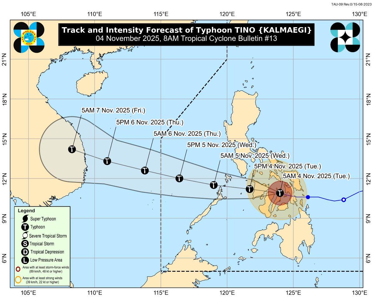
Tino's center was last estimated at 7 a.m. to be located in the vicinity of Sagay City, Negros Occidental.
The typhoon is moving west northwestward at 25 km/h.
It has maximum sustained winds of 150 km/h near the center, with gustiness of up to 205 km/h and central pressure of 960 hPa.
From Tino's center, strong to typhoon-force winds are extending outwards up to 300 km from the center.
Rainfall
Eastern Samar, Southern Leyte, Leyte, Dinagat Islands, Cebu, Negros Occidental, Surigao del Norte, Aklan, Iloilo, Guimaras, and Capiz may have more than 200 mm of rainfall today, according to PAGASA's heavy rainfall outlook issued at 5 a.m.
Northern Samar, Oriental Mindoro, Sorsogon, Biliran, Samar, Bohol, Camiguin, Antique, Siquijor, Negros Oriental, Romblon, Masbate, Misamis Oriental, and Agusan del Norte will have 100 to 200 mm of rainfall.
Meanwhile, 50 to 100 mm of rainfall may be expected in Surigao del Sur, Batangas, Catanduanes, Albay, Palawan, Marinduque, Occidental Mindoro, Maguindanao del Norte, Maguindanao del Sur, Sultan Kudarat, Misamis Occidental, Zamboanga del Norte, Lanao del Norte, Agusan del Sur, Bukidnon, Sarangani, and Lanao del Sur.
Winds
Gale-force gusts may be felt today in Cagayan Valley, Cordillera Administrative Region, Ilocos Norte, Ilocos Sur, Central Luzon, Metro Manila, CALABARZON, MIMAROPA, Bicol Region, Sarangani, Davao Occidental, and Davao Oriental, due to the surge of the Northeast Monsoon (Amihan) and the shear line coinciding with the passage of Tino.
Storm surge
PAGASA warned of a high risk of life-threatening and damaging storm surge.
The waves may peak at more than 3.0 m within the next 36 hours over the low-lying or exposed coastal communities of Masbate, Romblon, Oriental Mindoro, Occidental Mindoro, Palawan, Western Visayas, Negros Island Region, Central Visayas, Eastern Visayas, Dinagat Islands, and Camiguin, the weather bureau said.
Gale warning, coastal waters
"A Gale Warning is in effect over the eastern seaboard of Northern Luzon, the eastern and southern seaboards of Southern Luzon, the seaboards of Visayas, and the northern and eastern seaboards of Mindanao," PAGASA said.
Meanwhile, coastal waters will be up to very rough to high over the following coastal waters:
• Up to 7.0 m: The eastern seaboards of Calamian Islands, Eastern Samar, Dinagat Islands; the northern and eastern seaboards of Siargao and Bucas Grande Islands; the seaboard of Cuyo Islands; the southern seaboards of Oriental Mindoro and Occidental Mindoro.
• Up to 6.0 m: The seaboard of Antique; the eastern seaboards of northern mainland Palawan,and Leyte; the southern seaboard of Samar; the northern seaboard of Dinagat Islands; the western seaboard of Aklan; the remaining seaboard of Eastern Samar.
• Up to 5.0 m: The seaboard of Capiz; the northern and eastern seaboards of Northern Samar, northern Cebu including Bantayan and Camotes Islands; the northern seaboard of Negros Occidental; the western seaboards of Leyte and Dinagat Islands, the eastern seaboards of Sorsogon, Southern Leyte, and northern Iloilo; the southern seaboards of Masbate and Romblon; the remaining seaboard of Aklan.
• Up to 4.5 m: The seaboards of Camarines Norte, Albay, Biliran, Agusan del Norte, and Camiguin; the northern and eastern seaboards of Polillo Islands and Catanduanes; the northern and western seaboards of Surigao del Norte; the northern seaboard of Camarines Sur; the eastern seaboard of mainland Cagayan and Oriental Mindoro; the remaining seaboards of Sorsogon, Romblon, Masbate, and Visayas.
"Sea travel is risky for all types or tonnage of vessels. All mariners must remain in port or, if underway, seek shelter or safe harbor as soon as possible until winds and waves subside," PAGASA said.
Up to rough seas meanwhile are to be expected over the following coastal waters:
• Up to 3.5 m: The seaboards of Batanes, Babuyan Islands, Isabela, Aurora, northern mainland Quezon, and Cagayancillo Islands; the eastern seaboard of Camarines Sur; the remaining seaboards of Catanduanes, mainland Cagayan and Caraga Region.
• Up to 3.0 m: The seaboard of La Union, Marinduque, and Surigao del Sur; the western seaboards of Pangasinan, Occidental Mindoro, northern mainland Palawan, and Calamian Islands; the eastern seaboard of Davao Oriental; the remaining seaboards of Quezon, Bicol Region, and Northern Mindanao.
"Mariners of small seacrafts, including all types of motorbancas, are advised not to venture out to sea under these conditions, especially if inexperienced of operating ill-equipped vessels," PAGASA said.
Up to moderate seas on the other hand are forecast over the following coastal waters:
• Up to 2.5 m: The seaboard of Davao Occidental.
• Up to 2.0 m: The seaboards of Zambales and Zamboanga del Norte; the western seaboard of Bataan; the seaboard of Batangas; the remaining seaboards of Pangasinan, Palawan, Occidental Mindoro, and Oriental Mindoro.
"Mariners of motorbancas and similarly sized vessels are advised to take precautionary measures while venturing out to sea and, if possible, avoid navigation under these conditions," PAGASA said.
Track
The weather bureau said Tino made landfall over Borbon, Cebu and Sagay City, Negros Occidental.
Tino will continue traversing Visayas and northern Palawan, then emerge over the West Philippine Sea on Wednesday morning.
The typhoon is forecast to exit the Philippine Area of Responsibility by Wednesday evening or Thursday early morning.
Death toll
One was reported dead while 59,918 persons or 17,124 families were affected due to the onslaught of Typhoon Tino, according to the National Disaster Risk Reduction and Management Council Tuesday.
In its 6 a.m. situational report, NDRRMC said it is still validating the death of one unidentified woman.
Classes, flights
Classes for Tuesday, November 4, 2025, were suspended in some areas due to the expected effects of Typhoon Tino.
Several flights were canceled on Tuesday, November 4, due to the inclement weather conditions brought about by Tino. —KG/AOL, GMA Integrated News
