

Northern Palawan remains under Signal No. 4 as Typhoon Tino keeps strength
Typhoon Tino maintains its strength as it moves over the coastal waters of northern Palawan, keeping some areas under Signal No. 4, weather bureau PAGASA said.
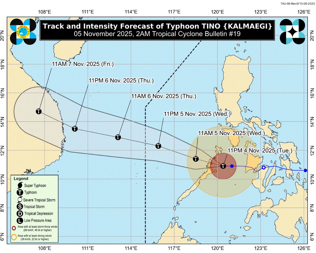
In its 2 a.m. cyclone bulletin, it said that Signal No. 4 remains hoisted over the northernmost portion of Palawan (El Nido, Taytay, Araceli), including Calamian and Cuyo Islands.
"A very intense typhoon will affect the locality," PAGASA said, with winds of greater than 118 kilometers per hour up to 184 km/h may be expected in at least 12 hours.
Signal No. 3 is up over the northern portion of Palawan (Dumaran, San Vicente, Roxas).
Signal No. 2 is hoisted over the southern portion of Occidental Mindoro (Magsaysay, San Jose, Rizal, Calintaan), the southern portion of Oriental Mindoro (Bulalacao), and the central portion of Palawan (Puerto Princesa City) including Cagayancillo Islands, all in Luzon.
Antique, including Caluya Islands and the northwesternmost portion of Aklan (Buruanga, Malay) in the Visayas are also under Signal No. 2.
Signal No. 1 is up over the following Luzon areas: the rest of Occidental Mindoro including Lubang Islands, the rest of Oriental Mindoro, Romblon, and the southern portion of Palawan (Aborlan, Quezon, Narra, Sofronio Española) including Kalayaan Islands.
The following areas in the Visayas are also under Signal No. 1: the rest of Aklan, Capiz, Iloilo, Guimaras, and the western portion of Negros Occidental (Isabela, La Carlota City, Candoni, Bago City, Enrique B. Magalona, City of Sipalay, Valladolid, San Enrique, Ilog, City of Kabankalan, Hinigaran, Bacolod City, La Castellana, Moises Padilla, Cauayan, Murcia, Binalbagan, Silay City, Pulupandan, City of Himamaylan, Hinoba-An, City of Victorias, City of Talisay, Pontevedra, Manapla).
Location, movement
The center of Tino was estimated over the coastal waters of Araceli, Palawan. It is moving westward at 25 kilometers per hour with maximum sustained winds of 120 km/h near the center and gustiness of up to 165 km/h.
PAGASA said heavy rainfall, severe winds, and storm surge may still be experienced in localities outside the landfall point and the forecast confidence cone.
Tino is forecast to make another landfall over northern Palawan area Wednesday morning before emerging over the West Philippine Sea. On the forecast track, Tino may exit the Philippine Area of Responsibility by this Wednesday evening or Thursday early morning.
Tino is forecast to steadily re-intensify over the next days and may reach its peak intensity while over the West Philippine Sea, PAGASA said. —LDF, GMA Integrated News
