

Signal No. 4 up over El Nido, north Palawan as Typhoon Tino makes landfall in Batas Island, Taytay
Typhoon Tino kept its strength as it continued to threaten northern Palawan after making landfall in Batas Island, Taytay town, weather bureau PAGASA said.
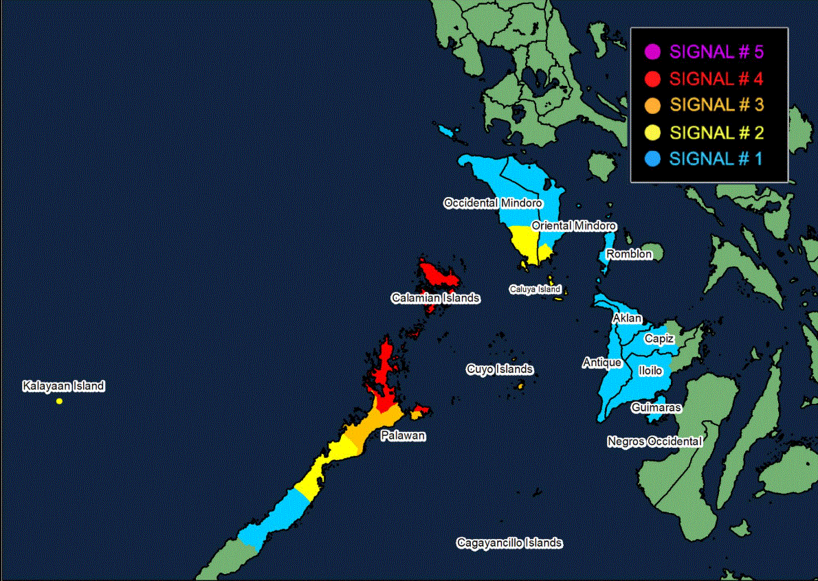
In its 5 a.m. cyclone bulletin, it said that Signal No. 4 remains hoisted over the northernmost portion of Palawan (El Nido, Taytay, Araceli), including Calamian Islands.
"A very intense typhoon will affect the locality," PAGASA said, with winds of greater than 118 kilometers per hour up to 184 km/h may be expected in at least 12 hours.
Signal No. 3 is up over the northern portion of Palawan (Dumaran, San Vicente, Roxas), including Cuyo Islands.
Signal No. 2 is hoisted over the southern portion of Occidental Mindoro (Magsaysay, San Jose, Rizal, Calintaan), the southern portion of Oriental Mindoro (Bulalacao), and the central portion of Palawan (Puerto Princesa City) including Cagayancillo Islands, all in Luzon, and in Caluya Islands in the Visayas.
Signal No. 1 is up over the following Luzon areas: the rest of Occidental Mindoro including Lubang Islands, the rest of Oriental Mindoro, the western portion of Romblon (Santa Fe, Santa Maria, Concepcion, Looc, Alcantara, Odiongan, San Jose, Ferrol, San Andres, Calatrava, Corcuera, San Agustin) and the southern portion of Palawan (Aborlan, Quezon, Narra, Sofronio Española) including Kalayaan Islands.
The following areas in the Visayas are also under Signal No. 1: Aklan, the rest of Antique, the central and western portions of Capiz (Sapi-An, Tapaz, Ivisan, Cuartero, Dumalag, Sigma, Dao, Mambusao, Jamindan, Dumarao), the central and southern portions of Iloilo (Calinog, New Lucena, Maasin, Oton, Pavia, Dueñas, Barotac Nuevo, Guimbal, Iloilo City, Tigbauan, Anilao, San Miguel, Leon, Mina, Santa Barbara, Leganes, Dingle, Zarraga, Bingawan, Cabatuan, Alimodian, Dumangas, San Joaquin, San Enrique, Badiangan, City of Passi, Pototan, Lambunao, Tubungan, Igbaras, Janiuay, Miagao), and Guimaras.
Location, movement
The center of Tino was estimated over the coastal waters of Linapacan, Palawan. It is moving west northwestward at 15 kilometers per hour with maximum sustained winds of 120 km/h near the center and gustiness of up to 150 km/h.
PAGASA said heavy rainfall, severe winds, and storm surge may still be experienced in localities outside the landfall point and the forecast confidence cone.
On the forecast track, Tino will continue to traverse northern Palawan Wednesday morning before emerging over the West Philippine Sea. It may exit the Philippine Area of Responsibility Wednesday night or Thursday early morning.
Tino is forecast to re-intensify in the next 12 hours and may reach its peak intensity while over the West Philippine Sea, PAGASA said. —LDF, GMA Integrated News
