

PAGASA: Tino intensifies; Signal no. 4 remains over northern Palawan
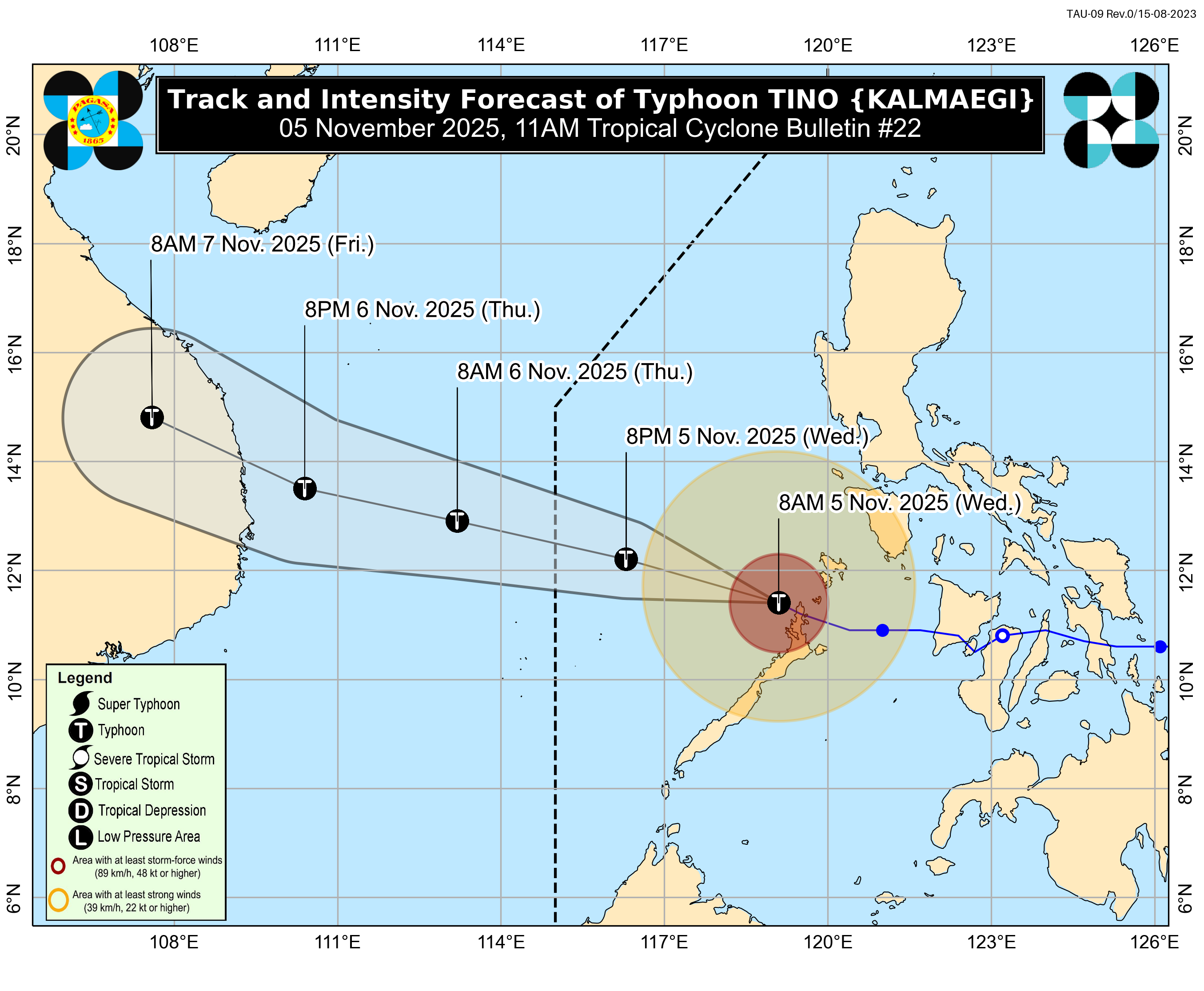
The northernmost portion of Palawan remains under Signal No. 4 as Typhoon Tino slightly strengthened and moves west of Palawan, the weather bureau said on Wednesday.
According to PAGASA’s 11 a.m. cyclone bulletin, the northern town El Nido remains under Signal No. 4 and will continue to experience typhoon-force winds of 118 to 184 km/h in at least 12 hours.
Two other northern towns--San Vicente and Taytay--including the Calamian Islands, are under Signal No. 3 and will face storm-force winds of 89 to 117 km/h in at least 18 hours, according to PAGASA.
The eastern and central portions of Palawan (including Puerto Princesa City, Roxas, Dumaran, and Araceli towns), including the Kalayaan Islands, remain under Signal No. 2, and will have gale-force winds of 62 to 88 km/h in at least 24 hours, the weather bureau said.
The following areas under Signal No. 1 will have strong winds of 39 to 61 km/h in at least 36 hours:
- Occidental Mindoro including Lubang Islands
- The southern portion of Oriental Mindoro (Bongabong, Roxas, Bulalacao, Mansalay)
- The southern portion of Palawan (Aborlan, Quezon, Narra, Sofronio Española) including Cuyo Islands
Strong to gale-force gust winds may also be expected in areas not under any wind signals due to the combined effects of the Northeast Monsoon, the shear line, and the trough of Typhoon Tino.
“The wind signals warn the public of the general wind threat over an area due to the tropical cyclone. Local winds may be slightly stronger/enhanced in coastal and upland/mountainous areas exposed to winds,” PAGASA warned. “Winds are less strong in areas sheltered from the prevailing wind direction,” it added.
According to PAGASA, Tino was last seen 190 kilometers west of Coron, Palawan.
As of the 11 a.m. report, the typhoon has maximum sustained winds of 130 km/h near the center, gustiness of up to 180 km/h, and central pressure of 970 hPa.
The state weather bureau also cautioned the public regarding the high risk of a storm surge with peak heights of 3.0 meters within the next 24 hours in coastal areas and low-lying communities in Palawan.
A gale warning is also in effect over the western and southern seaboards of Southern Luzon and the seaboards of Western Visayas.
Tino may re-intensify over the next 12 hours and reach peak intensity as it moves over the West Philippine Sea, the weather bureau said.
The typhoon is expected to exit the Philippine Area of Responsibility (PAR) by Wednesday night or Thursday early morning, according to PAGASA. —Jiselle Anne Casucian/MCG, GMA Integrated News
