

Uwan intensifies; Catanduanes, parts of Samar Island under Signal No. 2
Typhoon Uwan (international name: Fung-Wong) has intensified while four areas have been placed under Tropical Cyclone Wind Signal No. 2 on Saturday morning.
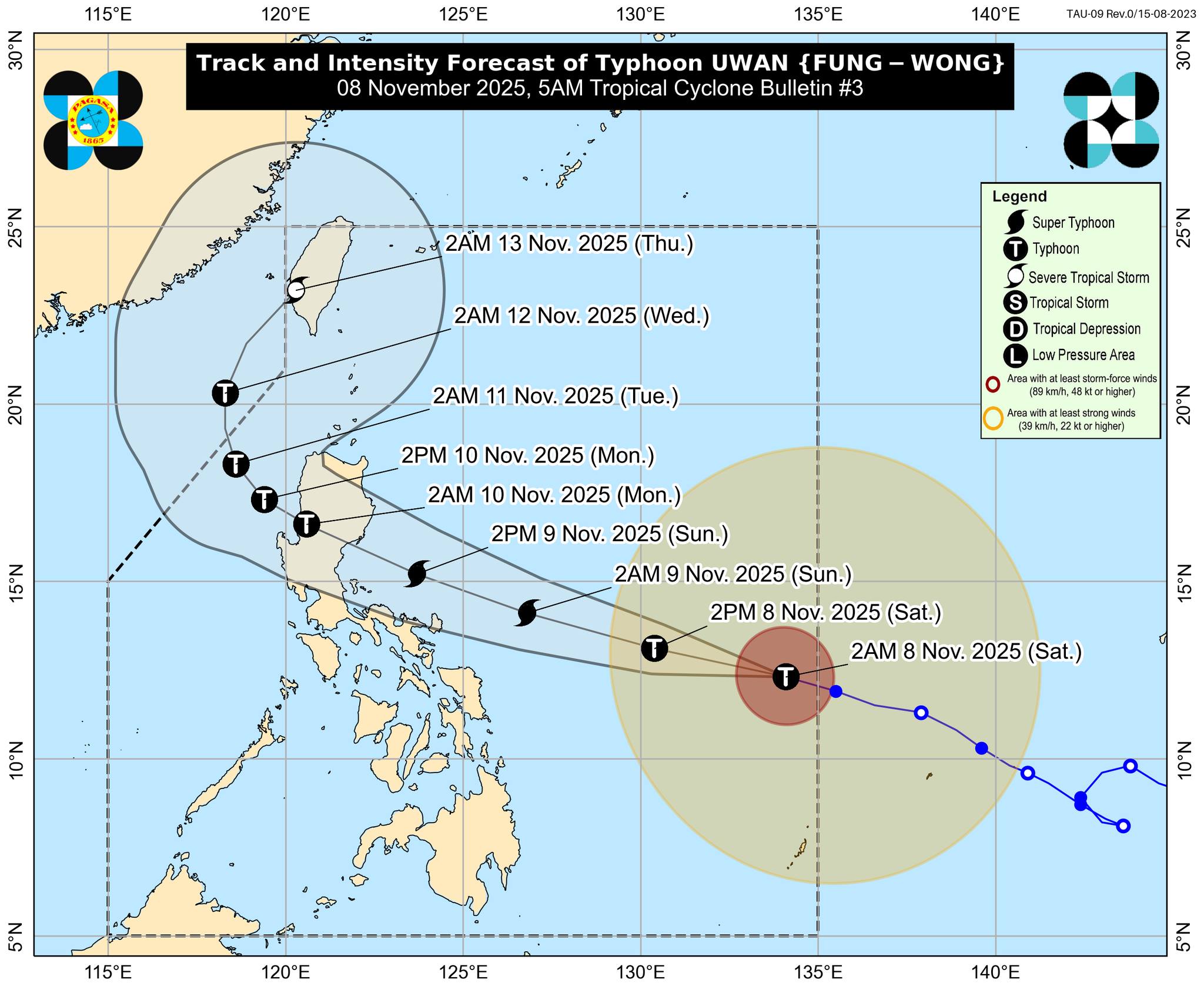
As of 4 a.m., Uwan was located 985 km east of Eastern Visayas, packing maximum sustained winds of 130 km/h near the center and gusts of up to 160 km/h, PAGASA said in its 5 a.m. Saturday bulletin.
It was moving west northwestward at 25 km/h.
Tropical Cyclone Wind Signal No. 2 was raised over Catanduanes, the eastern and central portions of Northern Samar (Lope de Vega, Palapag, Las Navas, Mapanas, Laoang, Catubig, Mondragon, Lapinig, Pambujan, Catarman, San Roque, Silvino Lobos, Gamay), the northeastern portion of Samar (Matuguinao, San Jose de Buan), and the northern portion of Eastern Samar (Maslog, San Policarpo, Dolores, Jipapad, Oras, Arteche)
Under Signal No. 1 are the following areas:
Luzon:
- Cagayan including Babuyan Islands
- Isabela
- Quirino
- Nueva Vizcaya
- Apayao
- Abra
- Kalinga
- Mountain Province
- Ifugao
- Benguet
- Ilocos Norte
- Ilocos Sur
- La Union
- Pangasinan
- Aurora
- Nueva Ecija
- Bulacan
- Tarlac
- Pampanga
- Zambales
- Bataan
- Metro Manila
- Cavite
- Laguna
- Batangas
- Rizal
- Quezon including Polillo Islands
- Camarines Norte
- Camarines Sur
- Albay
- Sorsogon
- Masbate including Ticao Island and Burias Islands
- Marinduque
- Romblon
- Oriental Mindoro
- Occidental Mindoro including Lubang Islands, and Calamian Islands
Visayas:
- the rest of Northern Samar
- the rest of Samar
- the rest of Eastern Samar
- Biliran
- Leyte
- Southern Leyte
- the northeastern portion of Bohol (Getafe, Talibon, Buenavista, Trinidad, San Miguel, Ubay, Alicia, Mabini, Bien Unido, Pres. Carlos P. Garcia)
- the northern and central portions of Cebu (Medellin, Daanbantayan, City of Bogo, Tabogon, San Remigio, Tabuelan, Borbon, Sogod, Tuburan, Catmon, Carmen, Danao City, Compostela, Liloan, Consolacion, Lapu-Lapu City, Mandaue City, Cordova, Asturias, Cebu City, Balamban, City of Talisay, Toledo City, Minglanilla) including Bantayan and Camotes Islands
- the northern portion of Negros Occidental (City of Escalante, Toboso, Sagay City, Cadiz City, Calatrava, Manapla, City of Victorias, Enrique B. Magalona, Silay City, City of Talisay, San Carlos City, Salvador Benedicto, Murcia, Bacolod City)
- the northern and central portions of Iloilo (Carles, Estancia, Balasan, San Dionisio, Concepcion, Batad, Sara, Ajuy, Barotac Viejo, San Rafael, Lemery, Lambunao, Calinog, Bingawan, City of Passi, San Enrique, Anilao, Banate, Dingle, Dueñas, Janiuay, Badiangan, Mina, Pototan, Barotac Nuevo, Dumangas)
- Capiz
- Aklan
- the northern and central portions of Antique (Pandan, Libertad, Sebaste, Culasi, Valderrama, Tibiao, Barbaza, Laua-An, Bugasong) including Caluya Islands
Mindanao:
- Dinagat Islands
- Surigao del Norte

Uwan is expected to reach super typhoon category on Saturday night or Sunday morning.
It is on track of making landfall over the southern portion of Isabela or the northern portion of Aurora late Sunday evening or early Monday morning.
The tropical cyclone will then traverse the mountainous terrain of Northern Luzon and emerge over the West Philippine Sea on Monday morning or afternoon.
"The interaction with the terrain will cause Uwan to weaken, but it is expected to remain as a typhoon throughout its passage over Northern Luzon and West Philippine Sea," PAGASA said.
Storm surge with peak heights exceeding 3.0 m within the next 48 hours are possible over the low-lying or exposed coastal communities of Isabela, Aurora, Quezon including Polillo Islands, Camarines Norte, Camarines Sur, Catanduanes, Albay, Sorsogon, Northern Samar, and Eastern Samar.
A gale warning is also in effect over the northern and eastern seaboards of Luzon and the eastern seaboard of Visayas.
Rainfall
PAGASA, in its heavy rainfall outlook issued at 5 a.m., said 50-100 mm of rainfall may be expected today over Eastern Samar, Northern Samar, and Catanduanes.
On Sunday, November 9, however, more areas will have rainfall due to Uwan:
- more than 200 mm of rainfall: Camarines Norte, Camarines Sur, Catanduanes, Albay, Aurora
- 100-200 mm: Cagayan, Isabela, Quirino, Nueva Vizcaya, Quezon, Sorsogon, Masbate, Northern Samar, Eastern Samar
- 50-100 mm: Apayao, Kalinga, Mountain Province, Ifugao, Abra, Benguet, Ilocos Norte, Ilocos Sur, La Union, Pangasinan, Nueva Ecija, Tarlac, Pampanga, Bulacan, Zambales, Bataan, Metro Manila, Cavite, Rizal, Laguna, Batangas, Marinduque, Oriental Mindoro, Occidental Mindoro, Romblon, Biliran, Samar
Classes were suspended in some areas on Saturday, Nov. 8, due to the possible effects of Uwan.
Some local government units also announced class suspensions for Monday, November 10. —VBL/KG, GMA Integrated News
