

Catanduanes under Signal No. 4 as Uwan intensifies
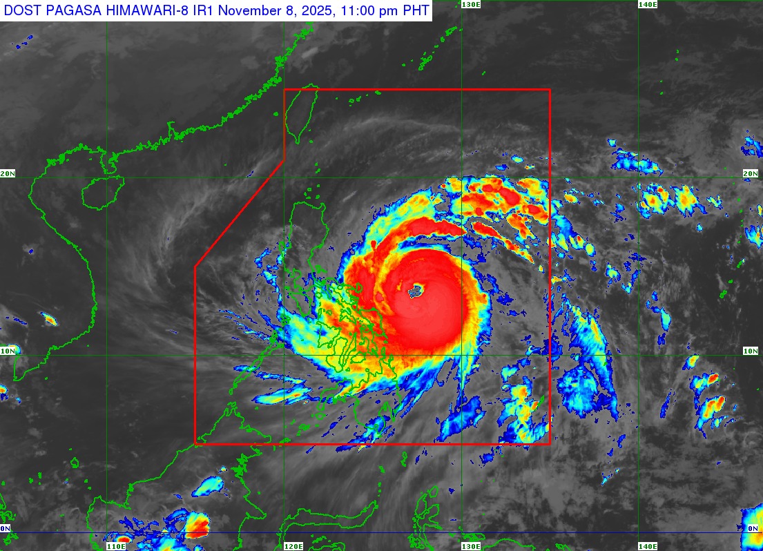
State weather bureau PAGASA raised Signal No. 4 over Catanduanes late Saturday evening as Typhoon Uwan continued to gather strength.
At 10 p.m., Uwan was seen 380 kilometers east of Virac, Catanduanes with maximum sustained winds of 155 km/h and gustiness of up to 190 km/h. It was moving west northwestward at 35 km/h.
Under Signal No. 3 are the following areas:
- Aurora
- the northern and eastern portions of Quezon (Pitogo, San Andres, Buenavista, San Francisco, Calauag, Infanta, Lopez, Catanauan, Mulanay, Guinayangan, Unisan, General Luna, Plaridel, Quezon, Alabat, Sampaloc, Macalelon, Mauban, General Nakar, Perez, Agdangan, Gumaca, Atimonan, Real, San Narciso, Tagkawayan) including Polillo Islands
- Camarines Norte
- Camarines Sur
- Albay
- the northern and eastern portions of Sorsogon (City of Sorsogon, Barcelona, Bulusan, Pilar, Castilla, Gubat, Casiguran, Donsol, Prieto Diaz)
- the eastern portion of Northern Samar (Palapag, Mapanas, Laoang, Gamay, Catubig, Pambujan, Biri)
Signal No. 2 was hoisted over the following areas:
- Mainland Cagayan
- Isabela
- Quirino
- Nueva Vizcaya
- Apayao
- Abra
- Kalinga
- Mountain Province
- Ifugao Benguet
- Ilocos Norte
- Ilocos Sur
- La Union
- Pangasinan
- Nueva Ecija
- Bulacan
- Tarlac
- Pampanga
- Zambales
- Bataan
- Metro Manila
- Rizal
- Laguna
- the rest of Quezon
- Cavite
- Batangas
- Marinduque
- the northern portion of Oriental Mindoro (Puerto Galera, San Teodoro, Baco, City of Calapan, Naujan, Pola, Victoria)
- the northern portion of Romblon (Banton)
- the rest of Sorsogon, and Masbate including Ticao and Burias Islands.
- the rest of Northern Samar
- the northern and central portions of Samar (Matuguinao, San Jose de Buan, Calbayog City, Tagapul-An, Santo Niño, Almagro, San Jorge, San Sebastian, Jiabong, Pagsanghan, City of Catbalogan, Gandara, Motiong, Santa Margarita, Tarangnan, Paranas, Hinabangan)
- the northern and central portions of Eastern Samar (Maslog, San Policarpo, Dolores, Jipapad, Oras, Arteche, Can-Avid, City of Borongan, Taft, Sulat, San Julian, Maydolong)
- the northern portion of Biliran (Maripipi)
Under Signal No. 1 are the following areas:
- Batanes
- Babuyan Islands
- the rest of Romblon
- the rest of Oriental Mindoro
- Occidental Mindoro
- Calamian Islands
- Cuyo Islands
- The rest of Samar
- the rest of Eastern Samar
- the rest of Biliran
- Leyte
- Southern Leyte
- Bohol
- the northern and central portions of Cebu (Medellin, Daanbantayan, City of Bogo, Tabogon, San Remigio, Tabuelan, Borbon, Sogod, Tuburan, Catmon, Carmen, Danao City, Compostela, Liloan, Consolacion, Lapu-Lapu City, Mandaue City, Cordova, Asturias, Cebu City, Balamban, City of Talisay, Toledo City, Minglanilla, Dumanjug, Argao, Sibonga, Barili, Ronda, Moalboal, Badian, Dalaguete, Alcantara, City of Carcar, City of Naga, San Fernando, Pinamungahan, Aloguinsan) including Bantayan and Camotes Islands
- the northern and central portions of Negros Occidental (City of Escalante, Toboso, Sagay City, Cadiz City, Calatrava, Manapla, City of Victorias, Enrique B. Magalona, Silay City, City of Talisay, San Carlos City, Salvador Benedicto, Murcia, Bacolod City, Hinigaran, City of Himamaylan, Binalbagan, Isabela, Moises Padilla, La Castellana, Pontevedra, San Enrique, La Carlota City, Bago City, Valladolid, Pulupandan)
- the northern portion of Negros Oriental (Canlaon City, Jimalalud, La Libertad, Tayasan, Vallehermoso, City of Guihulngan)
- Guimaras
- Iloilo
- Capiz
- Aklan
- Antique
- Dinagat Islands
- Surigao del Norte
- the northern portion of Agusan del Norte (Tubay, Santiago, Jabonga, Kitcharao)
- the northern portion of Surigao del Sur (Carrascal, Cantilan, Madrid, Carmen, Lanuza, Cortes)
“The wind signals warn the public of the general wind threat over an area due to the tropical cyclone. Local winds may be slightly stronger/enhanced in coastal and upland/mountainous areas exposed to winds. Winds are less strong in areas sheltered from the prevailing wind direction,” PAGASA said in its 11 p.m. bulletin.
The highest possible wind signal that may be raised remains at Signal No. 5.
Areas not under any wind signals may still experience occasionally gusty conditions reaching strong to gale-force strength.
PAGASA warned about a possible storm surge with peak heights exceeding 3.0 meters within the next 48 hours in Cagayan, Isabela, Ilocos Norte, Ilocos Sur, La Union, Pangasinan, Aurora, Zambales, Bataan, Pampanga, Bulacan, Metro Manila, Cavite, Batangas, Quezon, Camarines Norte, Camarines Sur, Catanduanes, Albay, Sorsogon, Northern Samar, Eastern Samar, Dinagat Islands, and Siargao and Bucas Grande Islands.
The seaboards of Northern and Central Luzon, the eastern and southern seaboards of Southern Luzon, and the eastern and central seaboards of Visayas and Mindanao have also been placed under gale warning.
“Heavy rainfall, severe winds, and storm surge may still be experienced in localities far from the landfall point and outside the forecast confidence cone,” shared PAGASA.
Uwan is expected to rapidly intensify into a super typhoon by Sunday and make landfall over Aurora by Sunday or Monday evening during or near its peak lifetime intensity.
"Furthermore, there is also an increasing possibility of a slight southward shift in the projected path of Uwan, which may result to a direct hit (i.e., eyewall affecting the area without making landfall) or a landfall scenario over Catanduanes," PAGASA said.
After landfall, Uwan will cross the mountainous terrain of Northern Luzon and emerge over Lingayen Gulf or the coastal waters of Pangasinan or La Union on Monday morning.
"The interaction with the terrain will cause Uwan to weaken significantly, but it is expected to remain as a typhoon throughout its passage over Northern Luzon," PAGASA said. —VBL, GMA Integrated News
