

Signal No. 4 over parts of Bicol as Uwan continues to intensify
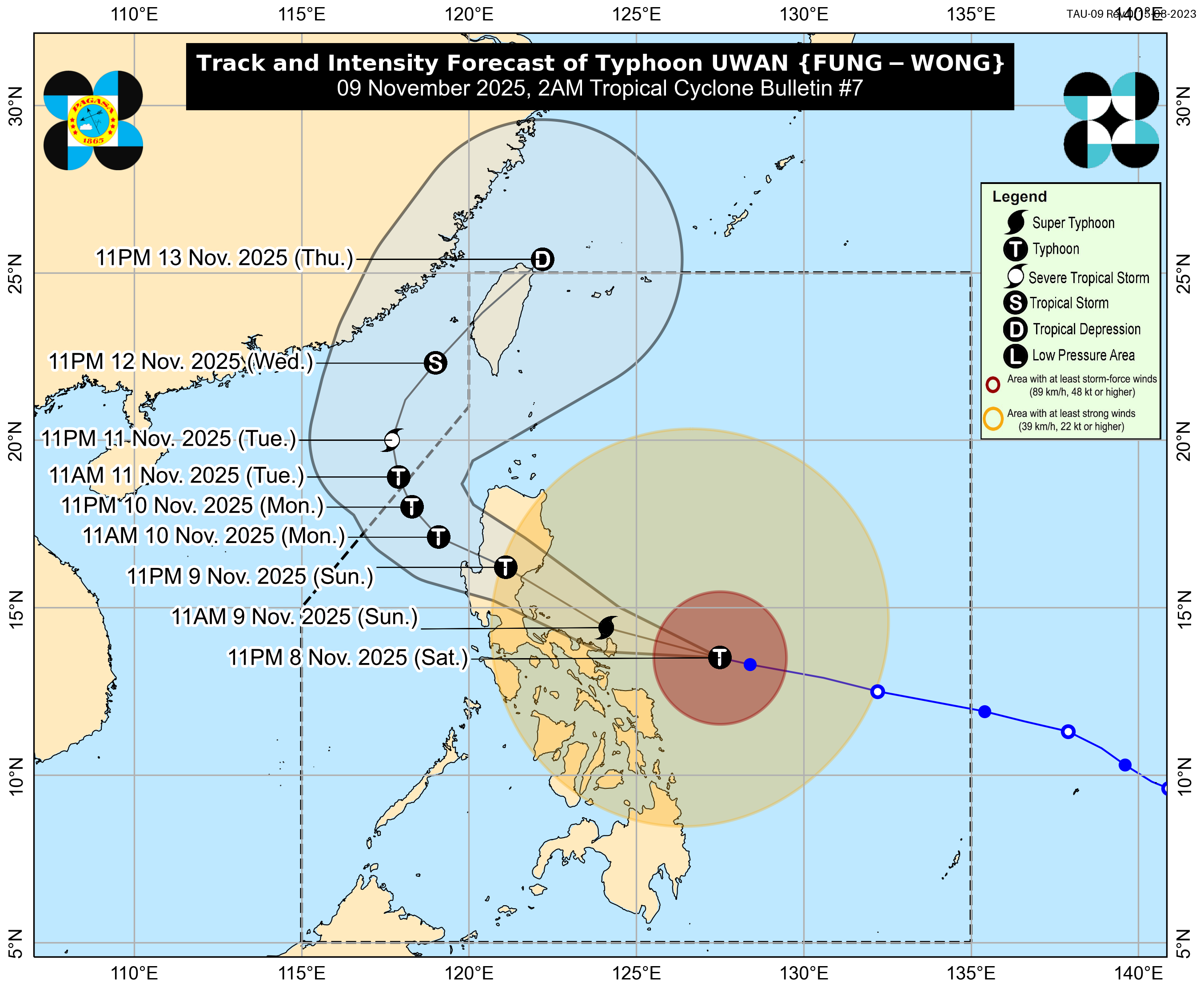
Parts of the Bicol region are under Signal No. 4 as Typhoon Uwan intensifies while moving closer to the area, PAGASA said on Sunday, November 9.
In its 2 a.m. advisory, PAGASA said the typhoon’s eye was located 370 kilometers east of Virac, Catanduanes (13.8°N, 126.7°E), moving west-northwest at 35 km/h.
Uwan packs maximum sustained winds near the center of 165 km/h, with gusts up to 205 km/h.
It is expected to reach super typhoon strength within the day and may make landfall at or near peak intensity.
Areas under Signal No. 4 are likely to experience the strongest winds.
The following areas are under Signal No. 4:
Luzon
- the southeastern portion of Camarines Norte (Mercedes, Basud, Daet, Talisay, Vinzons)
- eastern Camarines Sur (Sagñay, Tigaon, Goa, Calabanga, Tinambac, Siruma, Lagonoy, Garchitorena, San Jose, Presentacion, Caramoan, Cabusao)
- Catanduanes
- eastern Albay (Rapu-Rapu, Bacacay, City of Tabaco, Malilipot, Malinao, Tiwi)
The following areas are under Signal No. 3:
Luzon
- the central and southern portions of Isabela (Alicia, San Mariano, Ramon, Naguilian, Dinapigue, San Guillermo, City of Cauayan, Echague, Angadanan, Benito Soliven, City of Santiago, San Agustin, Palanan, San Isidro, Cordon, Jones)
- Quirino
- the eastern and southern portions of Nueva Vizcaya (Alfonso Castañeda, Dupax del Norte, Santa Fe, Kasibu, Aritao, Diadi, Dupax del Sur, Quezon)
- Aurora
- the eastern and central portions of Nueva Ecija (City of Gapan, San Leonardo, Rizal, San Isidro, Laur, Llanera, Pantabangan, Palayan City, Gabaldon, General Mamerto Natividad, Cabanatuan City, Carranglan, General Tinio, San Jose City, Santa Rosa, Peñaranda, Jaen, Bongabon, Cabiao)
- Bulacan
- the eastern portion of Pampanga (Mexico, San Luis, Santa Ana, Macabebe, Arayat, Candaba, Masantol, Santo Tomas, San Simon, Minalin, Apalit)
- Metro Manila
- Quezon including Pollilo Islands
- Laguna
- Rizal
- the eastern portion of Batangas (Padre Garcia, Santo Tomas, Lipa City, City of Tanauan, Mataasnakahoy, Balete, San Juan, Rosario, Malvar, Talisay, San Nicolas)
- the eastern portion of Cavite (Gen. Mariano Alvarez, Noveleta, Silang, City of Dasmariñas, Carmona, Kawit, Tagaytay City, Bacoor City, Imus City, Cavite City)
- the rest of Camarines Norte
- the rest of Camarines Sur
- the rest of Albay
- Sorsogon
- Ticao and Burias Islands
Visayas
- Northern Samar
- the northern portion of Eastern Samar (Jipapad, Arteche, San Policarpo, Oras, Dolores, Maslog)
- the northern portion of Samar (Calbayog City, Matuguinao, Gandara, Santa Margarita)
PAGASA said winds of 89–117 km/h are expected, causing heavy damage to high-risk structures, moderate damage to medium-risk structures, and light damage to low-risk structures. Banana plants, medium-strength houses, and some coconut trees may be downed or damaged.
The following areas are under Signal No. 2:
Luzon
- mainland Cagayan including Babuyan Islands
- the rest of Isabela
- the rest of Nueva Vizcaya
- Apayao
- Abra
- Kalinga
- Mountain Province
- Ifugao
- Benguet
- Ilocos Norte
- Ilocos Sur
- La Union
- Pangasinan
- the rest of Nueva Ecija
- Tarlac
- the rest of Pampanga
- Zambales
- Bataan
- the rest of Cavite
- the rest of Batangas
- Marinduque
- the northern and eastern portions of Romblon (Banton, Cajidiocan, Romblon, San Andres, Magdiwang, Calatrava, San Agustin, San Fernando, Concepcion, Corcuera)
- the northern and central portions of Oriental Mindoro (Puerto Galera, San Teodoro, Baco, City of Calapan, Naujan, Pola, Victoria, Socorro, Pinamalayan, Gloria, Bansud, Bongabong)
- the northern portion of Occidental Mindoro (Abra de Ilog, Paluan) including Lubang Islands
- mainland Masbate
Visayas
- the central portion of Eastern Samar (Can-Avid, City of Borongan, Taft, Sulat, San Julian, Maydolong)
- the central portion of Samar (Tagapul-An, Santo Niño, Almagro, San Sebastian, Jiabong, City of Catbalogan, Motiong, Tarangnan, Paranas, Hinabangan, San Jose de Buan, San Jorge, Pagsanghan, Calbiga, Pinabacdao, Villareal, Zumarraga, Daram, Talalora)
- Biliran
Winds of 62–88 km/h may cause light to moderate damage to structures, topple banana plants, and affect crops.
The following areas are under Signal No. 1:
Luzon
- Batanes
- the rest of Romblon
- the rest of Oriental Mindoro
- the rest of Occidental Mindoro
- Calamian Islands
- Cuyo Islands
Visayas
- the rest of Samar
- the rest of Eastern Samar
- Leyte
- Southern Leyte
- Bohol
- the northern and central portions of Cebu (Medellin, Daanbantayan, City of Bogo, Tabogon, San Remigio, Tabuelan, Borbon, Sogod, Tuburan, Catmon, Carmen, Danao City, Compostela, Liloan, Consolacion, Lapu-Lapu City, Mandaue City, Cordova, Asturias, Cebu City, Balamban, City of Talisay, Toledo City, Minglanilla, Dumanjug, Argao, Sibonga, Barili, Ronda, Moalboal, Badian, Dalaguete, Alcantara, City of Carcar, City of Naga, San Fernando, Pinamungahan, Aloguinsan) including Bantayan and Camotes Islands
- the northern and central portions of Negros Occidental (City of Escalante, Toboso, Sagay City, Cadiz City, Calatrava, Manapla, City of Victorias, Enrique B. Magalona, Silay City, City of Talisay, San Carlos City, Salvador Benedicto, Murcia, Bacolod City, Hinigaran, City of Himamaylan, Binalbagan, Isabela, Moises Padilla, La Castellana, Pontevedra, San Enrique, La Carlota City, Bago City, Valladolid, Pulupandan)
- the northern portion of Negros Oriental (Canlaon City, Jimalalud, La Libertad, Tayasan, Vallehermoso, City of Guihulngan)
- Guimaras
- Iloilo
- Capiz
- Aklan
- Antique
Mindanao
- Dinagat Islands
- Surigao del Norte
- the northern portion of Agusan del Norte (Tubay, Santiago, Jabonga, Kitcharao)
- the northern portion of Surigao del Sur (Carrascal, Cantilan, Madrid, Carmen, Lanuza, Cortes)
Wind Signal No. 1, with winds of 39–61 km/h, may cause slight or very light damage to exposed communities.
Uwan is forecast to pass near Catanduanes Sunday morning and make landfall over Aurora by Sunday evening or early Monday.
A direct hit on Catanduanes is not ruled out, PAGASA said.
The storm will reportedly traverse Northern Luzon’s mountainous terrain and emerge over Lingayen Gulf or Pangasinan/La Union coastal waters on Monday morning.
The mountainous terrain may weaken the typhoon slightly, but it is expected to remain a typhoon throughout its passage, according to the weather bureau.—MCG, GMA Integrated News
