

Uwan now a super typhoon; Signal No. 5 up over 4 areas
Four areas were placed under Tropical Cyclone Wind Signal No. 5 as tropical cyclone Uwan intensified into a super typhoon, PAGASA said Sunday morning.
Based on PAGASA’s 8 a.m. cyclone bulletin, the following areas are under TCWS No. 5:
- Polillo Islands;
- the northern portion of Camarines Norte (Daet, Talisay, Paracale, Vinzons, Jose Panganiban, Mercedes, Basud);
- the eastern portion of Camarines Sur (Siruma, Caramoan, Garchitorena, Tinambac, Lagonoy); and
- Catanduanes.
Meanwhile, TCWS No. 4 was hoisted in the following areas:
- the eastern portion of Quezon (Tagkawayan, Calauag, Guinayangan, Perez, Alabat, Quezon);
- the rest of Camarines Norte;
- the rest of Camarines Sur; and
- the eastern portion of Albay (Rapu-Rapu, Bacacay, City of Tabaco, Malilipot, Malinao, Tiwi, Polangui).
The following areas are under TCWS No. 3:
- the southern portion of mainland Cagayan (Tuao, Enrile, Solana, Tuguegarao City, Peñablanca, Iguig, Piat, Amulung);
- Isabela;
- Quirino;
- Nueva Vizcaya;
- The southern portion of Apayao (Conner);
- Kalinga;
- Abra;
- Mountain Province;
- Ifugao;
- Benguet;
- Ilocos Sur;
- La Union;
- Pangasinan;
- Zambales;
- Bataan;
- Tarlac;
- Pampanga;
- Nueva Ecija;
- Bulacan;
- Aurora;
- Metro Manila;
- Cavite;
- Batangas;
- Rizal;
- Laguna;
- The rest of Quezon;
- Marinduque;
- The rest of Albay;
- Sorsogon;
- Ticao;
- Burias Islands;
- Northern Samar;
- the northern portion of Eastern Samar (Jipapad, Arteche, San Policarpo, Oras, Dolores, Maslog); and
- the northern portion of Samar (Calbayog City, Matuguinao, Gandara, Santa Margarita, San Jose de Buan).
TCWS No. 2 was raised over the following areas:
- the rest of Cagayan including Babuyan Islands;
- the rest of Apayao;
- Ilocos Norte;
- Occidental Mindoro including Lubang Islands;
- Oriental Mindoro;
- Romblon;
- the rest of Masbate;
- the rest of Eastern Samar;
- the rest of Samar;
- Biliran; and
- the northern and central portions of Leyte (Leyte, Calubian, San Isidro, Tabango, Capoocan, Carigara, Barugo, San Miguel, Babatngon, Tacloban City, Alangalang, Tunga, Palo, Santa Fe, Pastrana, Matag-Ob, Tolosa, Mayorga, Julita, Dagami, Jaro, Villaba, La Paz, Tabontabon, Tanauan, Ormoc City, Dulag, Burauen, Kananga, Albuera, Palompon, Merida, Isabel).
The following areas are under TCWS No. 1:
- Batanes;
- Calamian Islands;
- Cuyo Islands;
- the rest of Leyte;
- Southern Leyte;
- Bohol;
- the northern and central portions of Cebu (Medellin, Daanbantayan, City of Bogo, Tabogon, San Remigio, Tabuelan, Borbon, Sogod, Tuburan, Catmon, Carmen, Danao City, Compostela, Liloan, Consolacion, Lapu-Lapu City, Mandaue City, Cordova, Asturias, Cebu City, Balamban, City of Talisay, Toledo City, Minglanilla, Dumanjug, Argao, Sibonga, Barili, Ronda, Moalboal, Badian, Dalaguete, Alcantara, City of Carcar, City of Naga, San Fernando, Pinamungahan, Aloguinsan) including Bantayan and Camotes Islands;
- the northern and central portions of Negros Occidental (City of Escalante, Toboso, Sagay City, Cadiz City, Calatrava, Manapla, City of Victorias, Enrique B. Magalona, Silay City, City of Talisay, San Carlos City, Salvador Benedicto, Murcia, Bacolod City, Hinigaran, City of Himamaylan, Binalbagan, Isabela, Moises Padilla, La Castellana, Pontevedra, San Enrique, La Carlota City, Bago City, Valladolid, Pulupandan);
- the northern portion of Negros Oriental (Canlaon City, Jimalalud, La Libertad, Tayasan, Vallehermoso, City of Guihulngan);
- Guimaras;
- Iloilo;
- Capiz;
- Aklan;
- Antique;
- Dinagat Islands;
- Surigao del Norte;
- the northern portion of Agusan del Norte (Tubay, Santiago, Jabonga, Kitcharao); and
- the northern portion of Surigao del Sur (Carrascal, Cantilan, Madrid, Carmen, Lanuza, Cortes).
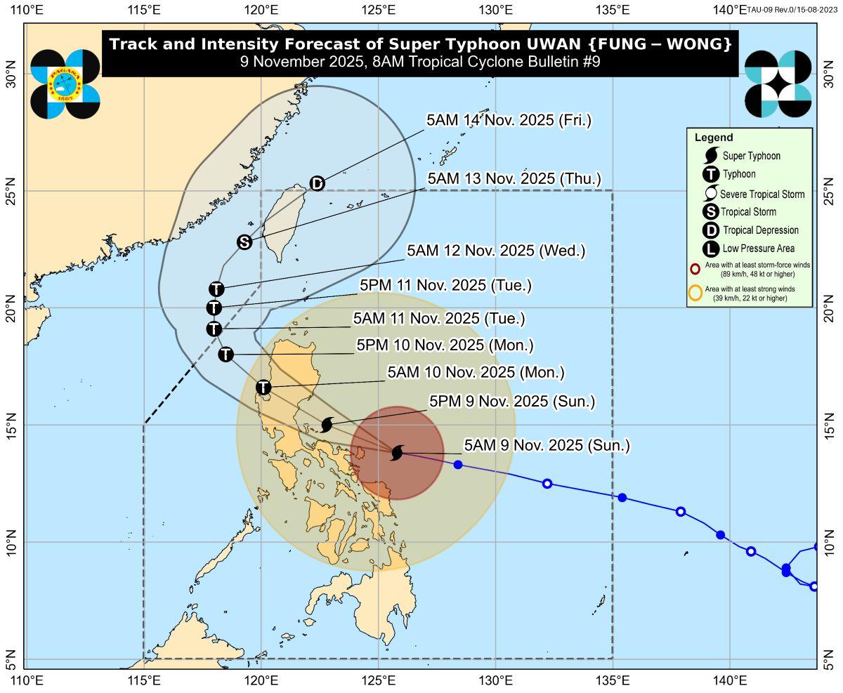
At 7 a.m., Uwan was last located at 125 km east northeast of Virac, Catanduanes, carrying maximum sustained winds of 185 km/h near the center and gusts of up to 230 km/h, and is moving west northwestward at 25 km/h.
Winds
“The wind signals warn the public of the general wind threat over an area due to the tropical cyclone,” PAGASA said.
“Local winds may be slightly stronger/enhanced in coastal and upland/mountainous areas exposed to winds. Winds are less strong in areas sheltered from the prevailing wind direction,” it added.
The state weather bureau further warned that on Sunday, Uwan will bring occasionally gusty conditions reaching strong to gale-force strength over Palawan, Visayas, and Mindanao, which are not under any wind signal.
Storm surge
Within the next 48 hours, a high risk of life-threatening and damaging storm surge with peak heights exceeding 3.0 meters is expected over the low-lying or exposed coastal communities of Cagayan, Isabela, Ilocos Norte, Ilocos Sur, La Union, Pangasinan, Aurora, Zambales, Bataan, Pampanga, Bulacan, Metro Manila, Cavite, Batangas, Quezon, Camarines Norte, Camarines Sur, Catanduanes, Albay, Sorsogon, Northern Samar, Eastern Samar, Dinagat Islands, and Siargao and Bucas Grande Islands.
A gale warning is also in effect over the seaboards of Northern and Central Luzon, the eastern and southern seaboards of Southern Luzon, the eastern and central seaboards of Visayas, and the eastern seaboard of Mindanao.
Track
The storm is expected to move west northwestward over the next 24 hours.
PAGASA said the center of the eye of Uwan may pass close to Catanduanes this morning and make landfall over Aurora Sunday night or early Monday morning.
“Due to its proximity, a direct hit (i.e., eyewall affecting the area without making landfall) or a landfall scenario over Catanduanes is possible,” PAGASA said.
“Heavy rainfall, severe winds, and storm surge may still be experienced in localities far from the landfall point and outside the forecast confidence cone,” it added.
Uwan may make landfall at or near its peak lifetime intensity.
“The interaction with the terrain will cause Uwan to weaken significantly, but it is expected to remain as a typhoon throughout its passage over Northern Luzon,” state meteorologists said.
“After landfall, Uwan will traverse the mountainous terrain of Northern Luzon and emerge over Lingayen Gulf or the coastal waters of Pangasinan or La Union on tomorrow (Monday) morning,” it added.
By Tuesday, the storm is expected to move northwestward until it exits the Philippine Area of Responsibility (PAR), before turning northeastward.
The center of Uwan will then re-enter the northwestern boundary of PAR by Thursday, traversing the landmass of Taiwan, and will exit PAR by Friday morning.
Classes, flights
Classes on Monday, Nov. 10, 2025, in some areas have been suspended amid the threat of Uwan (international name: Fung-Wong).
Several flights scheduled on November 9 and 10, 2025 were also canceled in anticipation of the onslaught of Uwan. —KG, GMA Integrated News
