

PAGASA: 42 areas at risk for storm surges amid Uwan onslaught
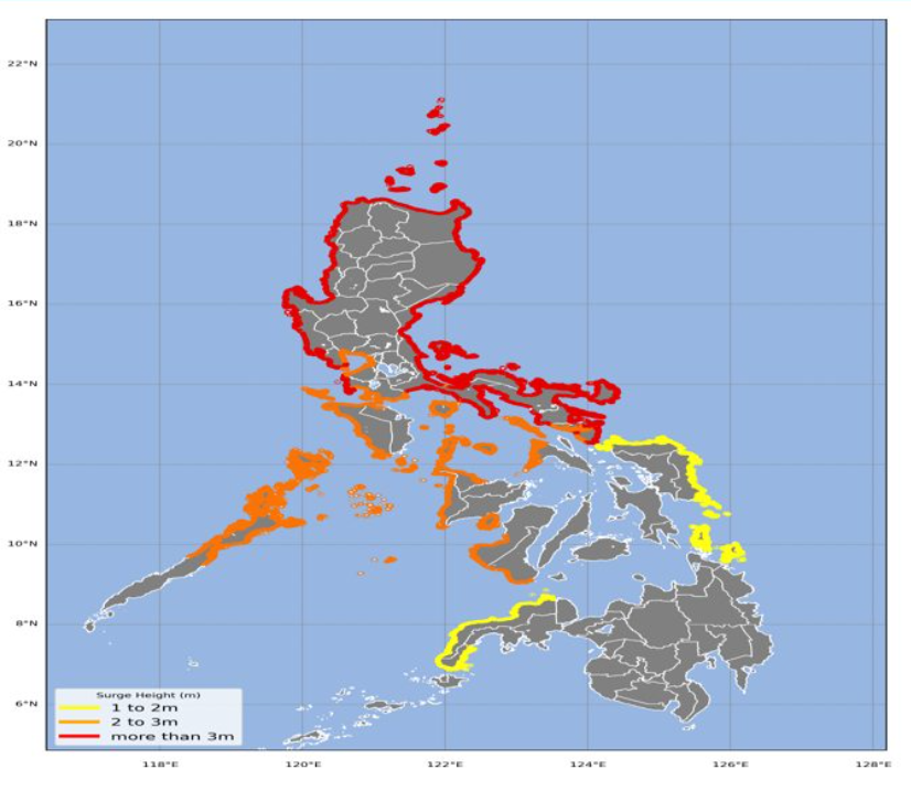
Forty-two areas across the country are at risk for dangerous storm surges – some exceeding three meters high – as Super Typhoon Uwan continues to batter the country, the state weather bureau said on Sunday night.
In its 8 p.m. storm surge warning on Sunday, PAGASA said the life-threatening storm surges may hit low-lying, coastal communities in the said provinces in the next 48 hours.
Coastal areas in the following provinces are at risk for storm surge heights of more than three meters:
- Albay
- Aurora
- Bataan
- Batangas
- Camarines Norte
- Camarines Sur
- Catanduanes
- Ilocos Norte
- Ilocos Sur
- Isabela
- La Union
- Pangasinan
- Quezon
- Sorsogon
- Zambales
- Cagayan, and
- Batanes.
Low-lying coastal communities in the following provinces are also at risk for storm surges between 2.1 to 3 meters:
- Bataan
- Batangas
- Bulacan
- Cavite
- Marinduque
- Masbate
- Metro Manila
- Pampanga
- Quezon
- Sorsogon
- Antique
- Palawan
- Occidental Mindoro
- Guimaras
- Negros Occidental
- Romblon
- Oriental Mindoro
- Aklan, and
- Negros Oriental.
Storm surge heights between 1.2 meters are likely to hit coastal communities in these provinces:
- Dinagat Islands
- Surigao del Norte
- Eastern Samar
- Zamboanga del Sur
- Zamboanga del Norte, and
- Northern Samar.
PAGASA warned residents of low-lying coastal areas in these provinces to stay away from the coast or beach, cancel all marine activities, and move to higher grounds away from the coast and storm surge-prone areas.
As of 9:10 p.m., Uwan has made landfall over landfall over Dinalungan, Aurora.
In its 8 p.m. tropical cyclone bulletin, the state weather bureau said the super typhoon is moving northwestward at 30 km/h and is packing maximum sustained winds of 185 km/h near the center with gustiness of 230/h and central pressure of 935 hPa.
Signal No. 5, the highest tropical cyclone signal, is hoisted over four areas in Luzon:
- The southern portion of Quirino (Nagtipunan)
- The southeastern portion of Nueva Vizcaya (Alfonso Castañeda, Dupax del Norte, Dupax del Sur)
- The northeastern portion of Nueva Ecija (Bongabon, Carranglan, Pantabangan), and
- The northern and central portion of Aurora (San Luis, Baler, Maria Aurora, Dipaculao, Dinalungan, Casiguran).
After its landfall, the state weather bureau said Uwan will cross the mountainous terrain of Northern Luzon and emerge over Lingayen Gulf or the coastal waters of Pangasinan or La Union by Monday morning.
“The interaction with the terrain will cause Uwan to weaken significantly, but it is expected to remain as typhoon throughout its passage over Northern Luzon,” PAGASA said. – JMA, GMA Integrated News
