

Signal No. 2 raised in 13 Luzon areas as Typhoon Uwan departs Ilocos Region
Signal No. 2 has been raised in 13 areas in Luzon as Typhoon Uwan moves away from the Ilocos Region, PAGASA said late Monday afternoon.
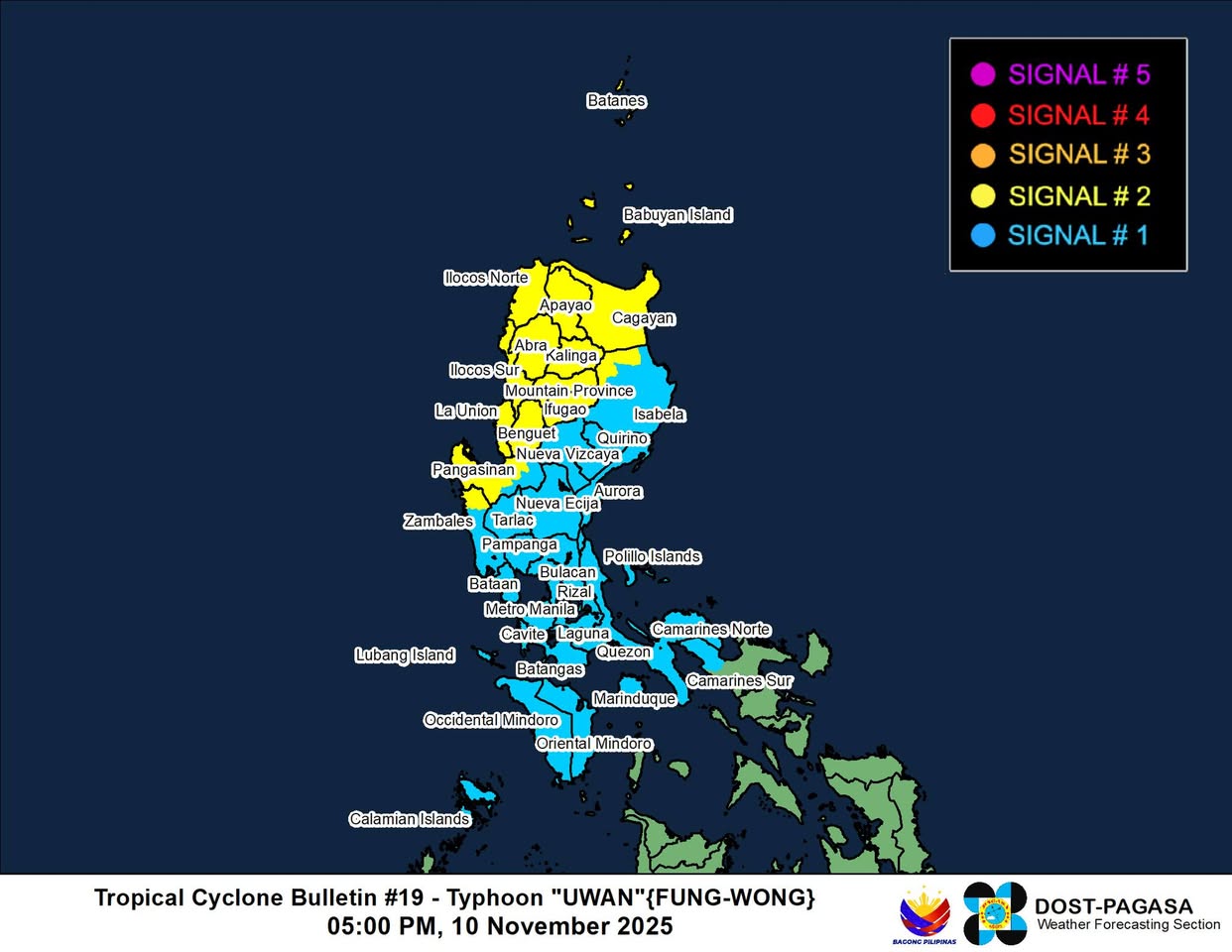
Based on PAGASA’s 5 p.m. cyclone bulletin, Signal No. 2 is placed under the following areas:
- Batanes
- Cagayan including Babuyan Islands
- The northwestern portion of Isabela (Santo Tomas, Santa Maria, Quezon, Roxas, Delfin Albano, San Pablo, Cabagan, San Manuel, Mallig)
- Apayao
- Abra
- Kalinga
- Mountain Province
- Ifugao, Benguet
- Ilocos Norte
- Ilocos Sur
- La Union
- The western and central portions of Pangasinan (Basista, Lingayen, City of Alaminos, Anda, Malasiqui, San Fabian, Mangaldan, Mapandan, Burgos, Dagupan City, Binalonan, Bolinao, Aguilar, San Manuel, Sual, Labrador, Bani, Pozorrubio, City of Urdaneta, Laoac, Mabini, San Carlos City, Manaoag, Binmaley, San Jacinto, Bugallon, Infanta, Agno, Calasiao, Santa Barbara, Dasol, Sison, Mangatarem, Urbiztondo)
- The northern portion of Zambales (Santa Cruz, Candelaria)
The following areas are under Signal No. 1:
- The rest of Isabela
- Quirino
- Nueva Vizcaya
- The rest of Pangasinan
- Aurora
- Nueva Ecija
- The rest of Zambales
- Bataan
- Tarlac
- Pampanga
- Bulacan
- Metro Manila
- Cavite
- Laguna
- Batangas
- Rizal
- Quezon including Polillo Islands
- Occidental Mindoro including Lubang Islands
- Oriental Mindoro
- Marinduque
- Calamian Islands
- Camarines Norte
- The northwestern portion of Camarines Sur (Sipocot, Libmanan, Lupi, Del Gallego, Ragay, Cabusao)
At 4 p.m., Uwan was located 175 km west of Sinait, Ilocos Sur, carrying maximum sustained winds of 120 km/h near the center and gusts of up to 150 km/h, and was moving northwestward at 10 km/h.
State meteorologists warned that on Tuesday, the storm will bring occasionally gusty conditions reaching strong to gale-force strength over most of Luzon that are not under any wind signal.
PAGASA also said that within the next 12 hours, a moderate to high risk of life-threatening storm surge with peak heights reaching 1.0 m to 3.0 meters is expected over the low-lying or exposed coastal communities of the Ilocos Region, Cagayan, including the Babuyan Islands, Isabela, Aurora, Zambales, Bataan, Cavite, Batangas, Occidental Mindoro, including Lubang Island, and the Calamian Islands.
A gale warning is also in effect over the seaboards of Northern and Central Luzon and the western seaboards of Southern Luzon.
PAGASA also said heavy rainfall, severe winds, and storm surge may still be experienced far from the landfall point or center track, and even in areas outside the forecast confidence cone.
“Do not focus on the center track as it may still shift within the limit of the forecast confidence cone,” state meteorologists said.
Uwan is forecast to follow a recurving path and turn more northwestward on Monday, northward on Tuesday, and northeastward to eastward for the rest of the forecast period.
The storm may briefly re-intensify on Monday evening until Tuesday while it moves over the waters southwest of Taiwan, before eventually weakening from Wednesday onwards.
Uwan is expected to exit the Philippine Area of Responsibility on Monday evening or early Tuesday morning, but could re-enter by Wednesday evening as it makes landfall over the southwestern coast of Taiwan, resulting in further weakening.
It will then emerge over the waters near the Ryukyu Islands on Thursday, where it is expected to eventually weaken into a remnant low on Friday. –with a report from Sherylin Untalan/NB, GMA Integrated News
