

Signal No. 1 over 45 areas as Verbena emerges over Butuan Bay
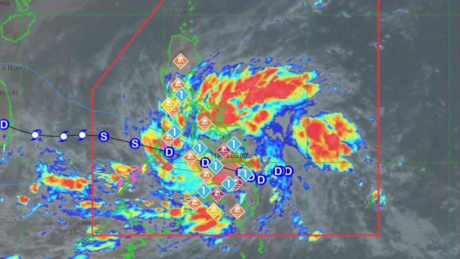
Signal No. 1 was hoisted over 45 areas as Tropical Depression Verbena emerged over Butuan Bay, PAGASA said Monday evening.
At 7 p.m., Verbena was located over the coastal waters of Jabonga, Agusan del Norte, carrying maximum sustained winds of 45 km/h near the center and gusts of up to 70 km/h. It was moving west northwestward at 25 km/h.
Based on the state weather bureau’s 8 p.m. cyclone bulletin, the following areas are under Signal No. 1:
Luzon
- Occidental Mindoro
- Oriental Mindoro,
- Romblon
- The northern and central portions of Palawan (Araceli, Taytay, El Nido, Dumaran, Roxas, San Vicente, Puerto Princesa City) including Calamian, Cuyo,
- Cagayancillo Islands
- Mainland Masbate Balud
- Mandaon
- Milagros
- Cawayan
- Placer
- Pio V. Corpuz
- Esperanza
- Uson
- Dimasalang
- City of Masbate
- Mobo
- Palanas
- Aroroy
- Cataingan
- Baleno
Visayas
- Antique
- Aklan
- Capiz
- Iloilo
- Guimaras
- Negros Occidental
- Negros Oriental
- Siquijor
- Cebu
- Bohol
- Samar
- Eastern Samar
- Biliran
- Leyte
- Southern Leyte
Mindanao
- Dinagat Islands
- Surigao del Norte
- Surigao del Sur
- Agusan del Norte
- Agusan del Sur
- Camiguin
- Misamis Oriental
- The northern portion of Bukidnon (Baungon, Libona, Manolo Fortich, Sumilao, Impasug-Ong, City of Malaybalay, Malitbog, Cabanglasan)
- The northern portion of Misamis Occidental (Sapang Dalaga, Calamba, Baliangao, Plaridel, Lopez Jaena, Oroquieta City, Aloran, Panaon, Jimenez, Concepcion)
- The northern portion of Zamboanga del Norte (Jose Dalman, Manukan, Pres. Manuel A. Roxas, Katipunan, Dipolog City, Polanco, Piñan, Dapitan City, La Libertad, Sibutad, Rizal, Mutia)
PAGASA warned that areas under Signal No. 1 may experience minimal to minor impacts from strong winds.
On Tuesday, the surge of the Northeast Monsoon (Amihan) combined with the storm will bring gusty conditions reaching strong to gale-force strength over Luzon, Visayas, Dinagat Islands, Surigao del Norte, Agusan del Norte, Surigao del Sur, Davao Oriental, Misamis Oriental, Lanao del Norte, Misamis Occidental, and Zamboanga del Norte, which are not under any wind signal.
A gale warning remains in effect over the northern seaboard of Northern Luzon.
“It must be emphasized that heavy rainfall, severe winds, and storm surge may still be experienced in localities outside the landfall point and outside the forecast confidence cone,” PAGASA said.
“Furthermore, the track may still shift within the limit of the forecast confidence cone,” it added.
The storm is expected to move west northwestward across Visayas and the northern portion of Palawan between Monday evening and Tuesday evening, before emerging over the West Philippine Sea on Wednesday morning.
It will then turn westward and pass north of Kalayaan Islands and exit the Philippine Area of Responsibility on Thursday.
“Veberna but will likely cross Visayas as a tropical depression. It may reach tropical storm category either before reaching northern Palawan or once over the West Philippine Sea,” the state weather bureau said.
“Verbena may peak at severe tropical storm category while in the middle of the West Philippine Sea north of Kalayaan Islands,” it added. —Mariel Celine Serquiña/RF, GMA Integrated News
