We use cookies to ensure you get the best browsing experience. By continued use, you agree to our privacy policy and accept our use of such cookies. For further information, click FIND OUT MORE.
Make this your preferred source to get more updates from this publisher on Google.
Typhoon Quiel changed course and picked up strength. State weather forecasters now expect the cyclone to bring its winds of 160-195 kilometers per hour to the Isabela-Aurora area, sparing Cagayan province from the brunt of its impact upon landfall. Storm Signal No. 3 now covers northern Aurora and the provinces of Isabela, Mountain Province, Ifugao, Nueva Vizcaya, Quirino, Benguet, Ilocos Sur, La Union, and Pangasinan, according to the Philippine Atmospheric, Geophysical and Astronomical Services Administration (PAGASA) in its 5 a.m. severe weather bulletin Saturday. PAGASA said no longer under Signal No. 3 but now under Signal No. 2 are Cagayan, Apayao, Abra and Kalinga. Also under Signal No. 2 are: - Ilocos Norte - the rest of Aurora - Nueva Ecija - Tarlac - Pampanga - Zambales - Bulacan - northern Quezon - Polillo Island Signal No. 1 was hoisted over Metro Manila and these areas: - the rest of Quezon - Camarines Norte - Rizal - Bataan - Cavite - Laguna - Batangas - Lubang Island - Babuyan Islands - Calayan Group of Islands Quiel is still forecast to dump up to about one inch of rain per hour within its 500-kilometer span. Estimated rainfall over the Magat dam catchment area is 200 - 400 millimeters (mm) or 8 to 16 inches.
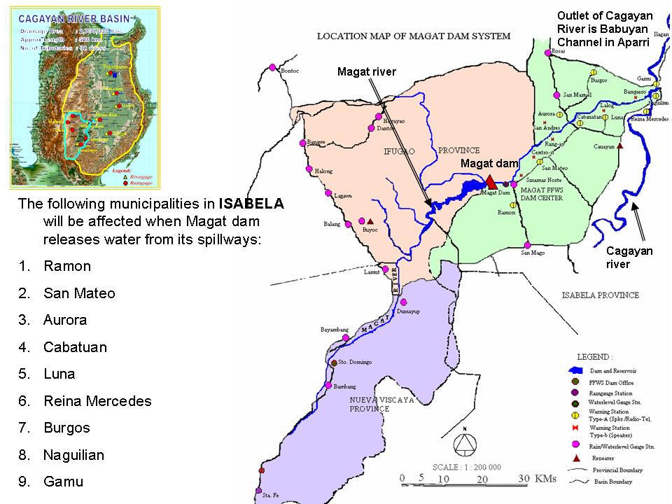
Nine towns of Isabela province are downstream from the Magat dam. Source: PAGASA PRFFWC
Quiel-induced monsoon clouds over the catchment area of Angat dam are forecast to bring rainfall of 80 - 100 mm or 3 to 4 inches. Seven spill gates of the Magat dam in Isabela province were raised open to 12 meters to let out water and make way for rain from Typhoon Quiel which is expected to make landfall Saturday morning. Landfall by 8 a.m. to 10 a.m. DOST Undersecretary Graciano Yumul Jr. said that with the course change, "Ang ating landfall inaasahan natin sa ibabaw ng Isabela at Aurora na, sa pagitan ng 8 at 10 a.m.," he said in an interview on dzBB radio. He said PAGASA projections show Quiel may exit northern Luzon via Ilocos Sur between 4 p.m. and 6 p.m. on Sunday. Yumul also said there is a chance Quiel may slam into the Sierra Madre mountain range and weaken after doing so. "Inaasahan natin hihina siya," he said. Yumul added that Metro Manila, now under Signal No. 1, can expect rain along with parts of Central Luzon such as flood-hit Bulacan and Pampanga. In its 5 a.m. advisory, PAGASA said "Quiel" was estimated at 160 km Northeast of Casiguran, Aurora as of 4 a.m. Saturday. Evacuation Preemptive evacuation intensified before dawn Saturday in coastal areas of Isabela province. Provincial police chief, Senior Superintendent Jimmy Rivera said these coastal areas are at high risk from floods and heavy rain from Quiel," radio dzBB's Carlo Mateo reported. Divilacan and Maconacon towns are being evacuated, the report said. In Divilacan, at least 15 families were brought to a nearby evacuation center. In Maconacon, 22 families or 77 people were initially brought to the Maconacon High School. "Kung pwedeng lumikas na sila, lumikas na," Undersecretary Yumul appealed to residents still in the path of Quiel. — ELR/HS, GMA News