

ADVERTISEMENT
Filtered By: Topstories
News
Typhoon Lawin intensifies further, nears Cagayan Valley; 4 areas under Signal 1
+
Make this your preferred source to get more updates from this publisher on Google.
Typhoon Lawin (Jelawat) intensified further Tuesday morning as it moved closer to Cagayan Valley, even as state weather forecasters warned it may make possible landfall in extreme Northern Luzon later this week.
"Typhoon 'Lawin' has maximum winds of 195 KPH near the center and gusts reaching 230 KPH and is expected to move north northwest at 11 KPH. With its impending threat to northern Luzon, signal 1 is now in effect over Isabela, Cagayan including Babuyan and Calayan group of islands where rainy and gusty weather conditions will prevail today," explained GMA resident weather forecaster Nathaniel "Mang Tani" Cruz.
"Enhanced habagat will bring occasional moderate to heavy rains that could trigger flashfloods and landslides over southern Luzon (except CALABARZON) and Visayas. The rest of Luzon including Metro Manila and Mindanao will continue to experience occasional light to moderate rains and thunderstorms. Gale warning is also in effect over the seaboards of the entire country (except central Luzon) and small sea crafts are advised not to venture out into the sea," he added.
Rain forecast for the 24 hours beginning 10 a.m., Sept. 25
PAGASA forecast
PAGASA forecaster Buddy Javier said Lawin may stay inside the Philippine Area of Responsibility (PAR) until at least this Saturday, due to a high-pressure area in the north that is slowing it down.
"Si Lawin lalong lumakas habang papalapit sa Cagayan Valley area. Lumaki siya," Javier said in an interview on dzBB radio.
He said their forecast models indicated that Lawin may make landfall over the extreme Northern Luzon area.
Javier added that Lawin could not go north quickly because a high-pressure area near Japan is blocking its northward path.
"Kikilos siya pataas pero may pumipigil sa kanya kaya hindi siya makakaakyat," he said.
As of Tuesday morning, the Japan Meteorological Agency (JMA) described Lawin as "violent" and indicated it may move north-northwest.
For its part, the US Joint Typhoon Warning Center (JTWC) described Lawin as a "super typhoon." 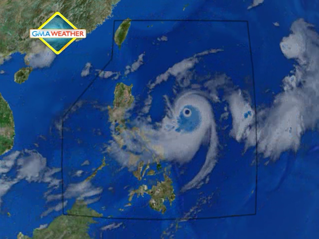
Satellite image of Typhoon Lawin (Jelawat).
Cyclone outside PAR now a tropical storm
The JMA and JTWC said a separate cyclone outside the PAR has intensified into a tropical storm and has been codenamed Ewiniar.
But Javier said their models show Ewiniar is not likely to affect the country even if it enters the PAR.
"Ine-expect natin kung papasok man hindi makakaapekto sa ating bansa," he said.
Lawin gains strength
PAGASA's 5 a.m. advisory indicated Lawin was estimated at 585 km east of Baler, Aurora as of 4 a.m. Tuesday, with maximum sustained winds of 195 kph near the center and gustiness of up to 230 kph.
It was moving north-northwest at 11 kph and is expected to be 425 km east of Tuguegarao City Wednesday morning, and 260 km east of Calayan Island Thursday morning.
By Friday morning it is expected to be 15 km north of Basco, Batanes.
"Residents living in low-lying and mountainous areas under public storm warning signal #1 are alerted against possible flash floods and landslides," it said.
It added Lawin may bring estimated rainfall of 10 to 20 mm per hour (heavy to intense) within its 800-km diameter.
Also, PAGASA said Lawin may enhance the southwest monsoon that will continue to bring moderate to heavy rain over Southern Luzon, Visayas, and Mindanao.
Stormy weather
PAGASA's bulletin also said that Isabela and Cagayan will have rain and gusty winds. MIMAROPA, Bicol and Visayas will experience cloudy skies with occasional moderate to heavy rain which may trigger flash floods and landslides.
Metro Manila, Calabarzon, Mindanao and the rest of Luzon will have occasional light to moderate rain and thunderstorms.
Moderate to strong winds blowing from the northeast to northwest will prevail over Central and Southern Luzon and coming from the southwest over Visayas and Mindanao.
The coastal waters along these areas will be moderate to rough.
Light to moderate winds coming from the northeast to northwest over the rest of Luzon with slight to moderate seas.
Gale warning
Strong to gale force winds enhanced by Typhoon Lawin may affect the western seaboard of Northern Luzon, the eastern seaboard of Southern Luzon and the seaboards of Visayas and Mindanao.
"Fishing boats and other small seacraft are advised not to venture out into the sea while larger sea vessels are alerted against big waves," PAGASA said. — TJD, GMA News
