

ADVERTISEMENT
Filtered By: Topstories
News
Typhoon Lawin nears Cagayan-Batanes, Signal 2 up over N. Luzon
+
Make this your preferred source to get more updates from this publisher on Google.
At least four areas were placed under Storm Signal No. 2 early Wednesday as Typhoon Lawin (Jelawat) moved closer to the Cagayan-Batanes area in Northern Luzon.
"Based on Weather Central's track, Lawin could make landfall in extreme northern Luzon on Friday then move towards Taiwan and will be out of the Philippine Area of Responsibility (PAR) by Sunday. Although Lawin's eye may not cross northern Luzon, its circulation is big enough for residents in these areas to feel its intense winds," said GMA resident forecaster Nathaniel "Mang Tani" Cruz.
"Storm Signal no. 2 is now in effect in Cagayan, including the Babuyan and Calayan group of islands, and the Batanes group of Islands. These areas will have stormy weather today and residents along coastal areas are alerted against big waves. Meanwhile, Signal no. 1 is now in effect in Ilocos Norte, Kalinga, Apayao, Abra and Isabela. Rainy weather with gusty winds will prevail in these areas," he added. PAGASA outlook
In an interview on dzBB radio, PAGASA forecaster Samuel Duran said Lawin may stay in PAR until Saturday or Sunday.
"Base sa kanyang kilos at bilis inaasahan natin Saturday or Sunday ito ay lalabas ng ating PAR (Based on Lawin's speed and strength, it is likely to stay in the Philippine Area of Responsibility until Saturday or Sunday)," he said.
He explained that a high-pressure area near Japan is influencing the movement of Lawin. Earlier, PAGASA forecasters said the HPA is slowing Lawin's northward movement.
On the other hand, Duran said another cyclone outside the PAR and near Japan, Tropical Storm Ewiniar, is not likely to enter the PAR.
"Ito papuntang norte, maaring hindi na dumaan sa ating PAR," he said. 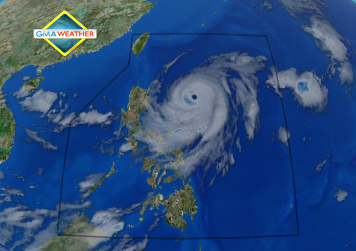
Satellite image of Typhoon Lawin as of 7 a.m., September 26.
PAGASA advisory
PAGASA's 5 a.m. advisory said that, as of 4 a.m., Lawin was estimated at 465 km east of Tuguegarao City, with maximum sustained winds of 205 kph near the center and gustiness of up to 240 kph.
It was moving northwest at 11 kph and is expected to be 325 km east of Calayan Island Thursday morning, and 45 km east of Basco, Batanes Friday morning.
By Saturday morning it is expected to be 220 km north of Itbayat, Batanes.
Warning vs flash floods, landslides
"Residents living in low-lying and mountainous areas under public storm warning signal #2 and #1 are alerted against possible flash floods and landslides," PAGASA warned.
Also, it said those living in coastal areas under public storm warning signal #2 are alerted against big waves or storm surges generated by Lawin.
PAGASA said Lawin may bring rainfall of 10 to 20 mm per hour (heavy to intense) within its 850-km diameter.
It also said Lawin will continue to enhance the southwest monsoon that will continue to bring moderate to heavy rain to Southern Luzon and Visayas.
PAGASA also said strong to gale force winds enhanced by Typhoon Lawin may affect the eastern seaboard of Central Luzon, the seaboards of Southern Luzon and Visayas and the northern and eastern seaboards of Mindanao.
"Fishing boats and other small seacrafts are advised not to venture out into the sea while larger sea vessels are alerted against big waves," it said.
Stormy weather, rough coastal waters
PAGASA said Cagayan, Calayan, Babuyan and Batanes Islands will experience stormy weather with rough to very rough seas.
Ilocos Norte, Kalinga, Apayao and Isabela will have rains and gusty winds. MIMAROPA, Bicol, and Visayas will experience cloudy skies with occasional moderate to heavy rain which may trigger flash floods and landslides.
Metro Manila, Calabarzon, Mindanao and the rest of Luzon will have occasional light to moderate rain and thunderstorms.
Moderate to strong winds blowing from the northeast to northwest will prevail over Central Luzon, Nueva Vizcaya and Quirino and coming from the southwest over Southern Luzon, Visayas and Mindanao.
The coastal waters throughout the archipelago will be moderate to rough. — TJD, GMA News
