

PH most disaster-prone country — 2025 report
The Philippines is the world’s most disaster-prone country in 2025, as tropical cyclones devastated communities all over the archipelago, while some flood control projects were found to not exist or “ghosts” while some are of substandard quality.
Released on Wednesday, the report was conducted by Germany’s Bündnis Entwicklung Hilft and Ruhr University Bochum.
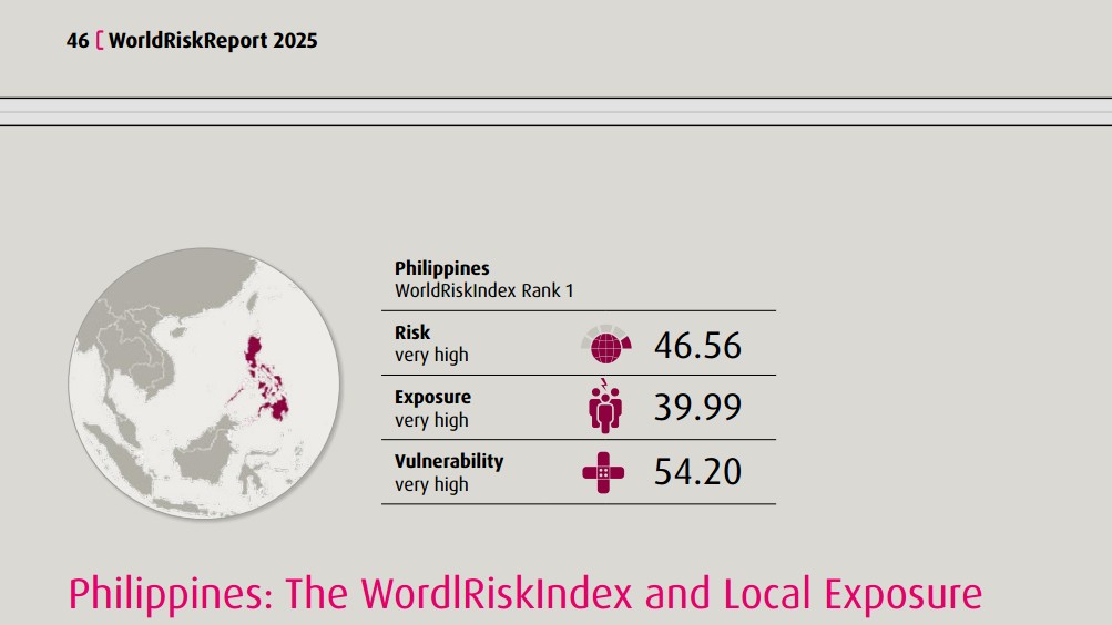
According to the 2025 WorlRiskIndex Report, the Philippines ranked first among 193 countries with a “very high” risk score of 46.56.
Joining the Philippines in the top 15 are:
2. India - 40.73
3. Indonesia - 39.80
4. Colombia - 39.26
5. Mexico - 38.96
6. Myanmar - 36.91
7. Mozambique - 34.39
8. Russian Federation - 31.22
9. China - 30.62
10. Pakistan - 26.82
11. Bangladesh - 26.71
12. Papua New Guinea - 26.51
13. Vietnam - 25.92
14. Peru - 25.81
15. Somalia - 24.89
The score of each country is based on its exposure to disasters, such as weather disturbances, flood, and earthquakes, and its vulnerability or how it might be affected.
The report described the Philippines as a country “characterized by high geographic fragmentation and high exposure to weather-related extremes.”
It showed that flood risk in the country varies by region and is influenced by geography, infrastructure, and spatial planning.
The report said exposure is particularly high in areas with flat topography, high population density, or inadequate drainage infrastructure, such as the provinces of Cagayan, Pampanga, or Agusan del Norte.
Meanwhile, Metro Manila and Laguna were cited as examples of how “urban planning, sewer systems, and retention areas can effectively reduce risk,” the report noted.
The top 10 most exposed to river and coastal flooding:
1. Cagayan - 88.10
2. Agusan del Norte - 87.51
3. Pangasinan - 85.19
4. Pampanga - 83.49
5. Maguindanao - 82.94
6. Metropolitan Manila - 81.12
7. Camarines Sur - 75.77
8. Misamis Oriental - 73.66
9. Camarines Norte - 72.69
10. Isabela - 71.23
Seven of these are in Luzon. the most populated island in the country, while the other three are in Mindanao.
The report pointed out that the Top 5 areas share a location in “lowland basins with flat topography, where water drains slowly and often remains standing for days.”
“Cagayan and Agusan del Norte are particularly vulnerable due to the combination of long main rivers, dense tributary systems, and extensive coastlines,” it stated.
Meanwhile, Marinduque, Laguna, Batanes, and Sarangani all have a large river system, which reduces flood risk in their respective areas.
The report also said the City of Manila is prone to flash flooding during heavy rainfall, as the ground is sealed off by the roads.
Anomalous flood control projects
The 2025 WorldRiskIndex report was published amid the ongoing investigation into anomalies of nationwide flood control projects and the successive tropical cyclones battering the country.
“Flood risks are increasing due to climate change and human interference with natural systems. Inadequate urbanization and destroyed ecosystems heighten vulnerability, especially in developing regions,” the report read.
The Department of Public Works and Highways said losses from anomalous flood control projects could reach up to trillions of pesos.
So far, the agency has filed a graft complaint against 25 individuals and four contractors over the flood control projects mess.
A report from “24 Oras” said 3,400 families have been evacuated in Cagayan as Super Typhoon Nando made landfall in the province last September 22.
After Nando’s exit from the Philippine Area of Responsibility, Severe Tropical Storm Opong entered the PAR on Tuesday and is expected to make landfall over Northern or Eastern Samar and over Sorsogon.
—RF, GMA Integrated News
