

DILG urges LGUs to evacuate high-risk communities by Sunday ahead of ‘Uwan’
Local government units (LGUs) should complete the evacuation of high-risk communities by Sunday in preparation for the impact of the potential super typhoon Uwan (international name: Fung-wong), the Department of the Interior and Local Government (DILG) said Friday.
In a statement, the DILG said the LGUs should plan out “worst-case or likely scenarios.”
“We are calling on all local chief executives to complete the evacuation of residents in high-risk areas no later than Sunday. Early evacuation saves lives,” the department said.
According to the DILG, LGUs should ready evacuation centers with sufficient supplies and power sources, as well as ensure proper management of evacuees.
LGUs are also urged to maintain coordination with Regional Disaster Risk Reduction and Management Councils (RDRRMCs).
LIVE UPDATES: Fung-wong (Uwan) Nov. 7, 2025
The DILG stressed the importance of real-time public information campaigns, particularly in communities vulnerable to flooding, landslides, and storm surges.
No-sailing policy and the suspension of tourism and outdoor activities in at-risk areas should be imposed, according to the DILG.
LGUs should mobilize equipment and personnel for road clearing and ensure unimpeded access for emergency and relief operations, it added.
“We cannot be complacent. The next 48 hours are crucial for preparedness. We urge everyone to stay informed, follow local advisories, and cooperate with authorities,” the department said.
_2025_11_07_08_50_48.jpg)
Fung-wong (Uwan)
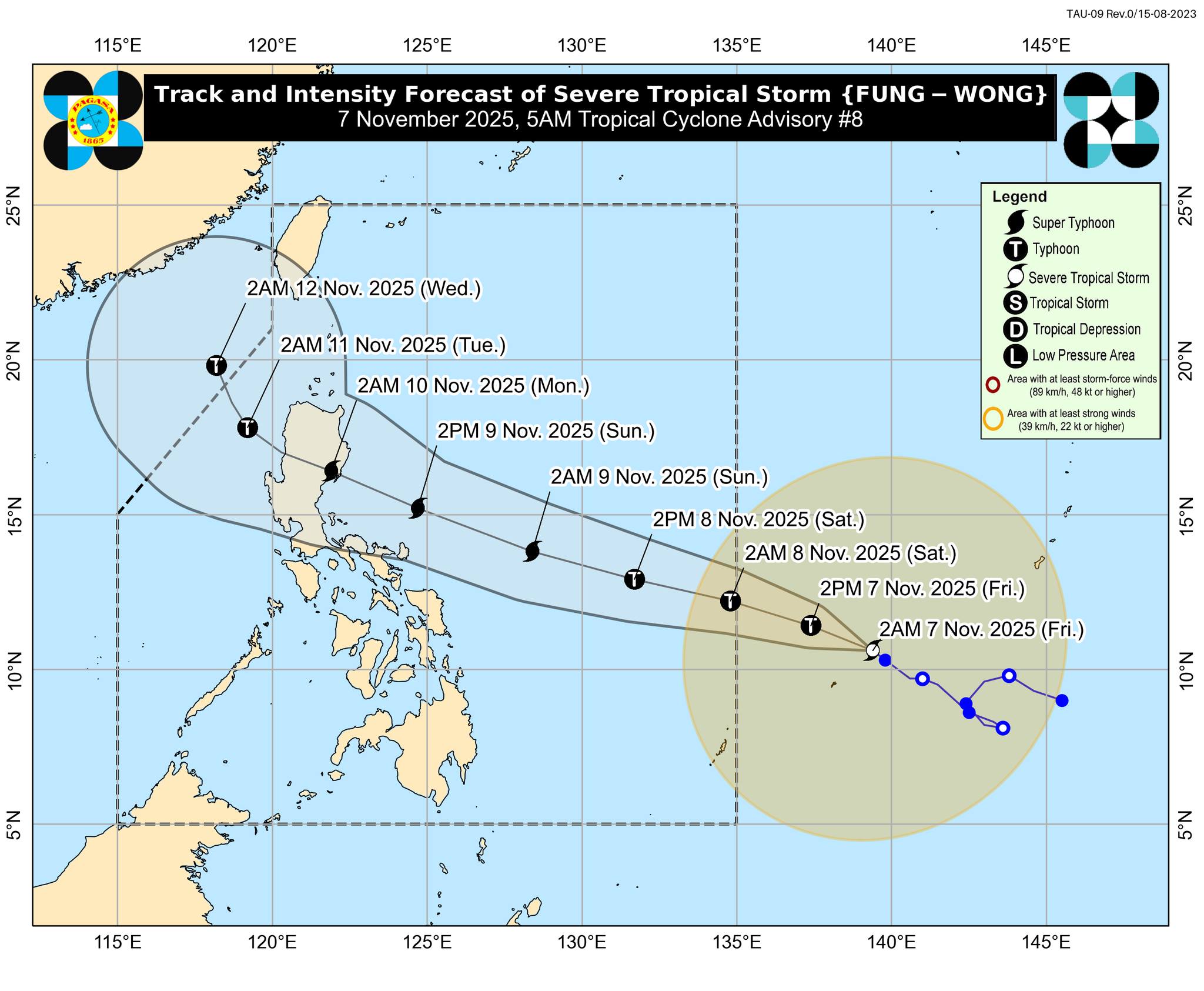
In its 5 a.m. advisory, state weather bureau PAGASA said Severe Tropical Storm Fung-wong was spotted 1,500 kilometers east of northeastern Mindanao or 1,470 km east of Eastern Visayas outside the Philippine area of responsibility (PAR)
The severe tropical storm was packing maximum sustained winds of 95 km per hour near the center and gustiness of up to 115 kph.
Fung-wong was moving northwestward at 10 kph.
According to PAGASA, Fung-wong is expected to enter the PAR by Friday midnight or early Saturday morning. It will be named locally as "Uwan."
"On the track forecast, this TC is forecast to enter the PAR by midnight or tomorrow (08 November) early morning. Once inside the PAR, the domestic name ‘UWAN’ will be assigned to this TC," PAGASA said.
"Although the uncertainty in track and intensity forecast is typically high for day-4 and day-5 forecasts, there is an increasing chance of landfall on Monday (10 November) over Northern or Central Luzon," it added.
The tropical cyclone may reach the super typhoon category, PAGASA said.
"In terms of intensity, this TC is forecast to rapidly intensify and may reach typhoon category in the next 24 hours and super typhoon category tomorrow evening or Sunday morning. It may also make landfall at or near its peak lifetime intensity," PAGASA said. —VAL, GMA Integrated News
