

PCG: Aircraft, vessels sent after 4 Chinese ships operating illegally in PH waters
The Philippine Coast Guard (PCG) will deploy aircraft and vessels after detecting four Chinese research ships conducting illegal maritime scientific research in the vicinity of Philippine waters.
In a statement on Sunday, PCG said the operations of the Chinese research vessels violated the United Nations Convention on the Law of the Sea (UNCLOS) since they operated without legal authority or prior consent of the Philippine government.
The Chinese research ships being monitored by the PCG are:
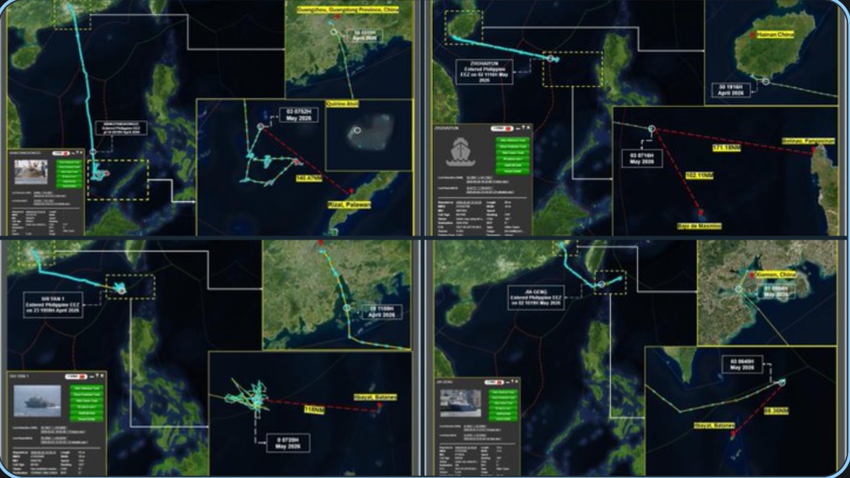
1. Xiangyanghong 33 is an advanced oceanographic survey vessel of the Xiang Yang Hong class, equipped for deep-sea research, seafloor mapping, geophysical exploration, and support of submersibles.
It was observed lying-to at Latitude 10.503101° N, Longitude 115.717853° E, approximately 140.47 nautical miles northwest off Rizal, Palawan, and within the vicinity of Quirino Atoll.
2. Shi Yan 1 is a SWATH-hulled research vessel specialized in marine science and hydro-acoustics, featuring dynamic positioning, noise reduction, and advanced sensors for precise geophysical and acoustic data collection.
It was underway at Latitude 20.568514° N, Longitude 119.815389° E, approximately 118 nautical miles west off Itbayat, Batanes.
3. Jia Geng is a modern deep-sea research vessel equipped with acoustic sensors, weather radars, and capable of deploying unmanned underwater vehicles for multidisciplinary oceanographic studies.
It was observed at Latitude 21.912450° N, Longitude 122.940958° E, approximately 88.36 nautical miles northeast off Itbayat, Batanes.
4. Zhuhaiyun is the world’s first intelligent drone mother ship, designed to deploy and control over 50 unmanned aerial, surface, and underwater vehicles simultaneously for comprehensive three-dimensional ocean surveys, with autonomous navigation capabilities.
It was lying-to at Latitude 16.665000° N, Longitude 116.830000° E, approximately 102.11 nautical miles northwest off BDM (alternatively, 171.18 nautical miles west off Bolinao, Pangasinan).
The PCG said that it will continue to monitor their movements in accordance with Philippine laws, international maritime law, and UNCLOS.
“We will not tolerate any illegal marine scientific research conducted without our government’s consent. We are deploying aircraft and vessels to challenge and drive away these unauthorized vessels to protect Philippine sovereignty and sovereign rights,” said PCG Commandant Admiral Ronnie Gil Gavan. —Mariel Celine Serquiña/RF, GMA News
