We use cookies to ensure you get the best browsing experience. By continued use, you agree to our privacy policy and accept our use of such cookies. For further information, click FIND OUT MORE.
Make this your preferred source to get more updates from this publisher on Google.
Undersecretary Benito Ramos, operations head of the National Disaster Risk Reduction and Management Council (NDRRMC), has claimed to reporters that Mindanao residents were warned about the dangers posed by the storm days earlier but they elected not to move to safer areas. However, the record shows that the NDRRMC issued its first bulletin on Sendong only on Thursday, December 15, at 11 a.m., urging local officials to "aim for zero casualties." The "severe weather bulletin" also advised local disaster councils to "initiate pre-emptive evacuation of families in low-lying and mountainous areas if situation warrants." By Friday night, Storm Sendong was slashing through northern Mindanao, with unsuspecting residents fast asleep in their homes. There was no known "pre-emptive evacuation" that took place. The NDRRMC takes its cues from PAGASA, which issued its first storm signals on Thursday as well, December 15, less than 24 hours before it forecast the storm's landfall in Mindanao.
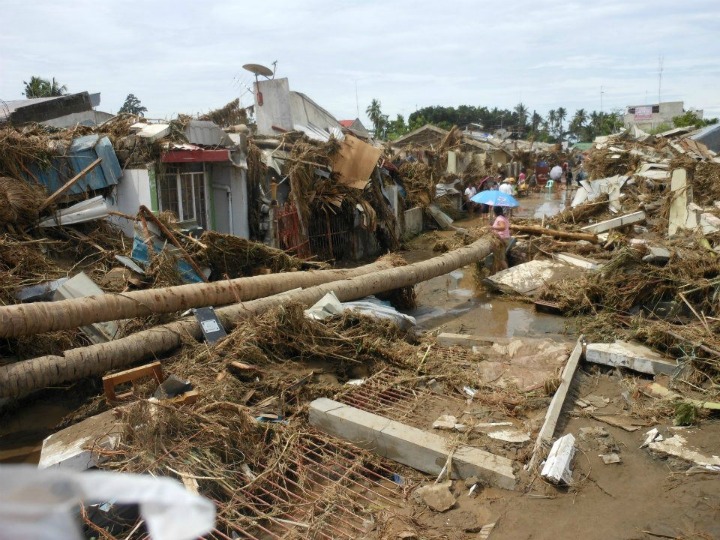
Residents were fast asleep in their homes, with no orders to evacuate, when Sendong roared through Iligan City. Irish Lungay
PAGASA's own policy is that it would raise storm signals at least 36 hours before a storm hits. The full force of Sendong in the major population centers of Cagayan de Oro and Iligan City began to be felt early Saturday morning (madaling araw), December 17. Yet as early as Tuesday, December 13, the Joint Typhoon Warning Center (JTWC) of the US Navy was already tracking a powerful storm heading for Mindanao. There was no word then from PAGASA. On the same day, December 13, a weather blogger, typhoonk, declared that Sendong/Washi "looks like a meanie."
As early as Dec 12, typhoonk was warning of an approaching "meanie".
The US agency National Oceanic and Atmospheric Administration (NOAA) had been forecasting the storm's western course for nearly a week. There was no mention of these forecasts on the PAGASA web site. A storm heading west towards Palawan, instead of the usual northern route towards Luzon, is a rare occurrence. Typhoonk noted on her blog that even after she posted findings by NASA early morning on Friday that Sendong was packing a "hot towering thunderstorm," there were still no new tweets or announcements from PAGASA. Sendong made landfall on midafternoon of Friday near Bislig, Surigao del Sur right on schedule and headed west as predicted for days by the US agencies. In the next 12 hours, as recounted by typhoonk, "Sendong made its way to Cagayan de Oror and Iligan City, hitting them in the dead hours of the night. It caught them by surprise." According to reports from Cagayan de Oro, the local disaster council had not been convened before Sendong smashed into northern Mindanao and triggered deadly flash flooding, with local officials saying later that storms did not usually pass their way. The Philippine Red Cross has reported over 600 dead from the effects of Sendong as of Saturday morning. Many are still missing, with reports of an entire coastal village swept out to sea. An exasperated typhoonk, who had been warning on her blog and Facebook page for several days that this was a storm of unusual magnitude, cried out online, "How can a typhoon that has been under observation by NOAA for almost a week, has kept pretty much to its forecast track, has made landfall 12 hours before, and has been travelling across Mindanao and the Visayas, take anyone by surprise?" A PAGASA official lamented on Saturday that Mindanao only has one Doppler radar for forecasting rainfall andstorm directions. - Howie Severino/ER, GMA News