

LOOK: PHIVOLCS's simulation of Kanlaon Volcano ash dispersion
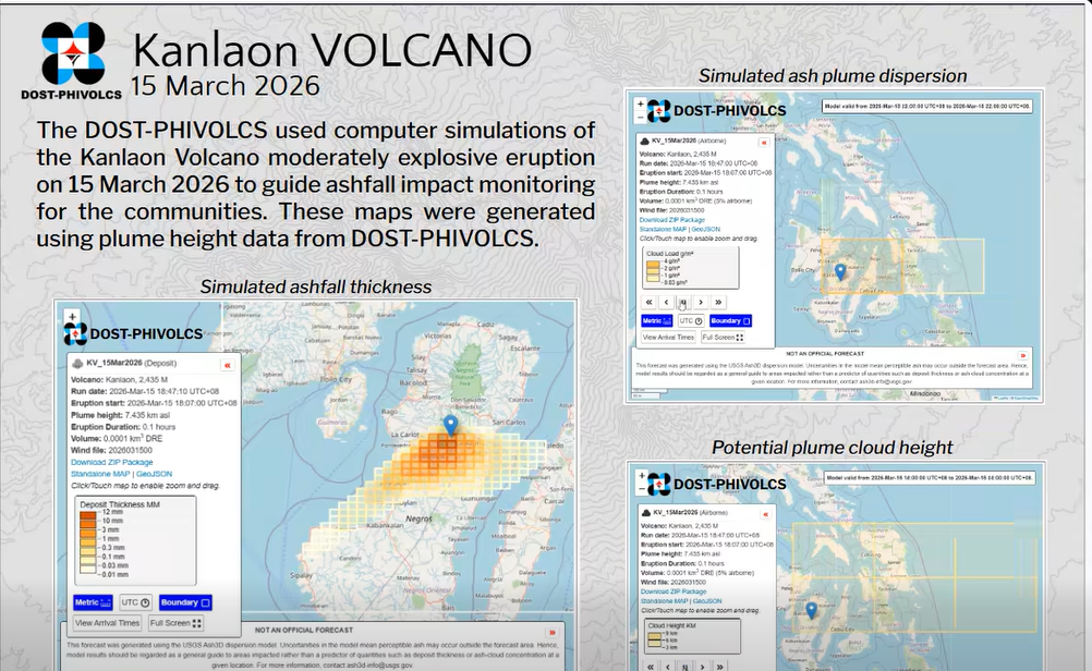
The Philippine Institute of Volcanology and Seismology (PHIVOLCS) on Sunday night released computer simulations of the ash dispersion amid the third moderately explosive eruption of Kanlaon Volcano earlier this evening.
In a post on its Facebook page, PHIVOLCS said it the maps were generated using plume height data and are meant to aid communities in ashfall impact monitoring.
The agency used Ash3D, an ash dispersion model, to guide volcanologists and local government units (LGUs) in monitoring the ashfall.
“Ang mga mapa ng kapal at distribusyon ng ashfall, dispersal (pagkalat), at taas ng ulap ay magagamit upang matukoy at ma-verify ang mga lugar na apektado o maaring maapektuhan ng ashfall,” PHIVOLCS said.
(The maps of the density and distribution of the ashfall, dispersal, and height of the plumes can be used to identify and verify the areas that are affected or might be affected by ashfall.)
PHIVOLCS logged the moderately explosive eruption of Kanlaon Volcano on Negros Island at around 6:07 p.m. Sunday, March 15. It generated a five-kilometer eruption column that is drifting to the southeast and northeast.
This is the third moderately explosive eruption for the volcano this year.
Kanlaon Volcano had two moderately explosive eruptions last month on February 19 and February 26, with the second eruption causing ashfall as well.
Alert Level 2 remains in effect over Kanlaon Volcano. Entry into its four-kilometer radius permanent danger zone (PDZ) is strictly prohibited. — JMA, GMA Integrated News
