

 GMA Brandtalk
 Tracking
 Archives

2 areas still under Signal No. 1 as Hanna intensifies
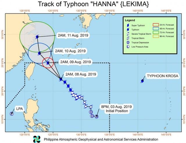
Typhoon Hanna has intensified further and continues to move towards the direction of southern Ryukyu Islands, PAGASA reported in Severe Weather Bulletin No. 12 issued early Thursday morning.
The center of Typhoon Hanna, as of 4 a.m., was located at 485 kilometers east northeast of Basco, Batanes with maximum sustained winds of 175 kph near the center and gustiness of up to 215 kph moving northwest at 15 kph.
Tropical Cyclone Wind Signal (TCWS) No. 1 is still hoisted over Batanes and Babuyan Group of Islands as the outer rainbands of Hanna will bring light to moderate with at times heavy rains and gusty winds.
Sea travel is risky over the seaboards of areas under TCWS No. 1, the seaboards of Luzon and Visayas, and the northern and eastern seaboards of Mindanao due to potentially rough sea conditions.
Hanna, which will continue to intensify as it moves closer towards the southern Ryukyu Islands, is less likely to make landfall and is expected to exit the Philippine Area of Responsibility (PAR) on Friday morning.
On Thursday, moderate to heavy monsoon rains may affect MIMAROPA, Zambales, Bataan, Cavite, and Batangas. Light to moderate with at times heavy rains may prevail over Metro Manila, the rest of Luzon and Western Visayas.
Residents in the affected areas, especially those living in flood-prone and landslide-prone areas are advised to take precautionary measures, coordinate with local disaster risk reduction and management offices, and continue monitoring for updates, especially the Thunderstorm Advisories and Heavy Rainfall Warnings to be issued by PAGASA Regional Services Divisions.
The state weather bureau continues to monitor two weather systems.
As of 4 a.m., the Low Pressure Area (LPA) was estimated at 270 km west of Dagupan City, Pangasinan. Based on all available data, the LPA is less likely to develop into a Tropical Depression.
Meanwhile, Typhoon Krosa was estimated at 1,940 km east of extreme northern Luzon or outside the PAR with maximum sustained winds of 120 kph near the center and gustiness of up to 150 kph and moving slowly in the northwest direction and is not expected to enter the PAR.
The weather bureau said occasional gusty conditions will continue over the western sections of Luzon and Visayas due to the enhanced Southwest Monsoon. — BAP, GMA News

