

Ulysses makes third landfall in General Nakar, Quezon; Signal No. 3 remains over 17 areas
Ulysses continues to intensify and the center of its eye has made landfall in the vicinity of General Nakar in Quezon province, according to the latest Severe Weather Bulletin issued by PAGASA.
Destructive winds and intense with at times torrential rainfall associated with the inner rainband-eyewall region of the typhoon will be experienced over central and southern portions of Aurora, the northern portion of Quezon including Polillo Islands, Metro Manila, Rizal, Bulacan, and Nueva Ecija within the next three hours. Moderate to heavy damage to infrastructure and vegetation is expected.
Hazards affecting land areas
Throughout the passage of the typhoon, destructive typhoon-force winds will be experiencing in areas under Tropical Cyclone Wind Signal (TCWS) No. 3, damaging gale- to storm-force winds in areas under TCWS No. 2, and strong breeze to near gale conditions in areas under TCWS No. 1.
The surge of the Northeast Monsoon will bring strong breeze to gale-force winds over the rest of Northern Luzon.
As of 1 a.m. on Thursday, the center of Ulysses was estimated based on all available data including those from Daet, Baler, Benguet, and Subic Doppler Weather Radars at 30 kilometers north of Infanta, Quezon and at 1:40 a.m. on Thursday, it was located in the vicinity of General Nakar, Quezon with maximum sustained winds of 155 kilometers per hour near the center and gustiness of up to 255 kph and moving West Northwestward at 20 kph.
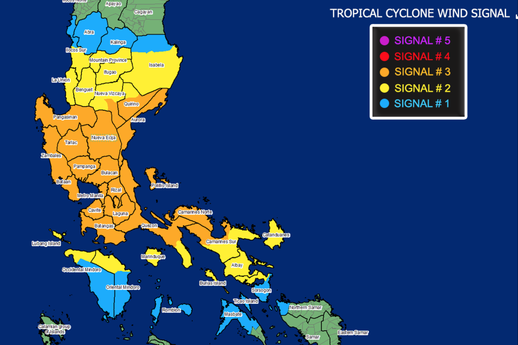
Tropical Cyclone Wind Signal (TCWS) No. 3 is hoisted over:
Luzon
- the southern portion of Quirino (Maddela, Nagtipunan)
- the southern portion of Nueva Vizcaya (Alfonso Castaneda, Dupax Del Norte, Dupax Del Sur)
- Pangasinan
- Nueva Ecija
- Aurora
- Tarlac
- Zambales
- Bataan
- Pampanga
- Bulacan
- Metro Manila
- Rizal
- Cavite
- Laguna
- Batangas
- the northern and central portions of Quezon (Catanauan, Buenavista, Guinayangan, Tagkawayan, Calauag, Lopez, Quezon, Alabat, Perez, Mauban, Real, Infanta, General Nakar, Sampaloc, Atimonan, Plaridel, Gumaca, General Luna, Macalelon, Pitogo, Unisan, Agdangan, Padre Burgos, Pagbilao, Lucena City, Tayabas City, Lucban, Sariaya, Candelaria, San Antonio, Tiaong, Dolores) including Polillo Islands
- the western portion of Camarines Norte (Labo, Paracale, Jose Panganiban, Capalonga, Santa Elena)
Tropical Cyclone Wind Signal No. 2 is hoisted over the following areas:
Luzon
- the central and southern portions of Isabela (Mallig, Quirino, Ilagan, Roxas, Burgos, Gamu, Palanan, San Mariano, Dinapigue, San Guillermo, Benito Soliven, Naguilian, Reina Mercedes, Luna, San Manuel, Aurora, Cabatuan, Cauayan City, San Mateo, Alicia, Angadanan, Echague, Jones, San Agustin, San Isidro, Ramon, Santiago City, Cordon)
- the rest of Quirino
- the rest of Nueva Vizcaya
- Mountain Province
- Ifugao
- Benguet
- the southern portion of Ilocos Sur (Cervantes, Quirino, San Emilio, Lidlidda, Santiago, Banayoyo, Candon City, Galimuyod, Gregorio Del Pilar, Salcedo, Santa Lucia, Santa Cruz, Sigay, Suyo, Tagudin, Alilem, Sugpon)
- La Union
- the northern portion of Occidental Mindoro (Paluan, Abra de Ilog) including Lubang Island
- the northern portion of Oriental Mindoro (Pola, Victoria, Naujan, Baco, Calapan City, San Teodoro, Puerto Galera)
- Marinduque
- the rest of Quezon
- the rest of Camarines Norte
- Camarines Sur
Tropical Cyclone Wind Signal No. 1 is hoisted over the following areas:
Luzon
- the rest of Isabela
- Kalinga
- Abra
- the rest of Ilocos Sur
- the rest of Occidental Mindoro
- the rest of Oriental Mindoro
- Romblon
- Albay
- Sorsogon
- Catanduanes
- the central and western portion of Masbate (Mandaon, Balud, Milagros, Mobo, Masbate City, Baleno, Aroroy) including Burias and Ticao Islands
Until noon on Thursday, heavy to intense with at times torrential rains over Camarines Norte, Metro Manila, CALABARZON, Central Luzon, Quirino, Nueva Vizcaya, and the eastern portion of Isabela.
Moderate to heavy with at times intense rains over Cordillera Administrative Region, the rest of mainland Cagayan Valley, Pangasinan, Marinduque, the northern portion of Mindoro Provinces including Lubang Island, and Camarines Sur.
Light to moderate with at times heavy rains over the rest of Luzon and Visayas.
Between noon on Thursday and tonight, heavy to intense with at times torrential rains over Zambales, Bataan, Cavite, Batangas, and the northern portion of Occidental Mindoro including Lubang Island.
Moderate to heavy with at times intense rains over Cordillera Administrative Region, mainland Cagayan Valley, Babuyan Islands, Pangasinan, Tarlac, Pampanga, Bulacan, Metro Manila, the rest of CALABARZON, the rest of Mindoro Provinces, and Calamian Islands.
Light to moderate with at times heavy rains over Western Visayas and the rest of Luzon.
Flooding (including flashfloods), rain-induced landslides, and sediment-laden streamflows such as lahar may occur during heavy or prolonged rainfall especially in areas that are highly or very highly susceptible to these hazards and/or those that received significant antecedent rainfall.
A Storm Surge Warning is in effect.
There is a high risk of storm surge with heights of up to 3 meters over the coastal areas of Aurora, Quezon including Polillo Islands, and Camarines Norte, and up to 2.0 m over the coastal areas of Isabela, La Union, Zambales, Bataan, Pampanga, Bulacan, Metro Manila, Cavite, Batangas, the northern portions of Mindoro Provinces including Lubang Island, Marinduque, Romblon, Masbate including Ticao and Burias Islands, Catanduanes, Camarines Sur, Albay, and Sorsogon.
These storm surges, which may be accompanied by swells and/or breaking waves near the coast, can cause life-threatening and damaging coastal inundation.
Moreover, there is also a moderate risk of seiche or storm surge over the coastal areas surrounding Laguna de Bay.
Hazards affecting coastal waters
Within the next 24 hours, the combined effects of Typhoon Ulysses and the surge of the Northeast Monsoon will bring rough to very high seas (2.5 meters to 11 meters) over the seaboards of areas under TCWS and the northern seaboard of Northern Samar, rough to high seas (3.0 to 6.0 m) over the remaining seaboards of Northern Luzon, and rough to very rough seas (2.5 to 4.5 m) over the western seaboard of Palawan including Calamian and Kalayaan Islands and the seaboards of Bicol Region not under TCWS. Sea travel is risky for all types of vessels over these waters.
Moderate to rough seas (1.5 to 2.5 m) will be experienced over the eastern seaboards of Visayas and Mindanao, the seaboards of Cuyo Islands, and the western seaboard of Panay Island.
Mariners of small seacrafts are advised to take precautionary measures when venturing out to sea. Inexperienced mariners should avoid navigating in these conditions
Track and intensity outlook
The center of the eye of Typhoon Ulysses made its second landfall in the vicinity of Burdeos, Quezon at 11:20 p.m. on Wednesday and its third landfall in the vicinity of General Nakar, Quezon at 1:40 a.m. on Thursday.
The typhoon is forecast to cross Central Luzon and emerge over the western seaboard of Zambales this morning.
On the forecast track, the typhoon may exit the Philippine Area of Responsibility on Friday morning or afternoon.
After making landfall at peak intensity, the typhoon is forecast to slightly weaken while crossing Central Luzon due to frictional effects in the presence of the Sierra Madre and Zambales Mountain Ranges. However, it is likely to remain a typhoon throughout its traverse. -- BAP, GMA News
