

Falcon decelerates over Philippine Sea; Habagat to bring rains —PAGASA
Tropical Storm Falcon (international name: Khanun) on Saturday morning decelerated while it moved westward over the Philippine Sea as the Southwest Monsoon brings rains over parts of Luzon and Visayas, PAGASA said in its bulletin.
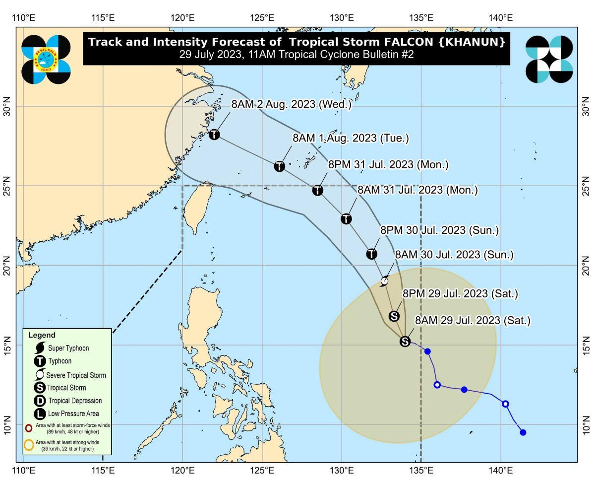
At 10 a.m., the eye of Falcon was located at 1,315 km east of Central Luzon.
Falcon has maximum sustained winds of 65 km/h near the center, gustiness of up to 80 km/h, and central pressure of 998 hPa.
The storm is moving westward at 10 km/h. No landfall is expected.
From Falcon's center, strong to gale-force winds are extending outwards up to 700 km.
PAGASA has not raised an tropical cyclone wind signals at this time.
Falcon and Tropical Storm Egay which is currently over mainland China will enhance the Southwest Monsoon (Habagat).
Parts of western Luzon and Visayas will thus have occasional to monsoon rains in the next three days.
More rainfall is expected in elevated or mountainous areas.
PAGASA said there may be flooding and rain-induced landslides especially in areas prone to these hazards and in localities that had considerable amounts of rainfall in the past few days.
Gusty conditions due to the monsoon will be felt in the following areas, especially in coastal and upland/mountainous locations exposed to the winds:
- Saturday: Zambales, Bataan, Palawan, Occidental Mindoro, Romblon, and most of Calabarzon, Bicol Region and Western Visayas;
- Sunday: Zambales, Bataan, Pampanga, Bulacan, Metro Manila, Occidental Mindoro, Palawan, Romblon, Northern Samar, and most of Calabarzon, Bicol Region and Western Visayas; and
- Monday: Ilocos Norte, Pangasinan, Zambales, Bataan, Pampanga, Bulacan, Metro Manila, Occidental Mindoro, Palawan, Romblon, Northern Samar, and most of Calabarzon, Bicol Region and Western Visayas.
Coastal waters
The weather bureau raised a gale warning over several coastal waters along the western seaboard of Luzon, the eastern and southern seaboards of Southern Luzon, and the eastern and western seaboards of Visayas due to the monsoon and Tropical Storm Falcon.
This would make it risky for small seacraft.
Meanwhile, PAGASA advised mariners without proper experience or operating ill-equipped vessels to remain in port or seek safe harbor.
Track, intensity
"FALCON is forecast to move generally north northwestward today through tomorrow, then turn generally northwestward on Monday," PAGASA said.
The storm is expected to exit the Philippine Area of Responsibility (PAR) between Monday evening or Tuesday morning.
However, Falcon is expected to intensify, becoming a typhoon on Sunday afternoon or evening and reach its peak intensity late Monday or early Tuesday.
Once outside PAR, Falcon may turn west northwestward, pass very close or make landfall in Okinawa, Japan between Monday evening and Tuesday morning, then head to East China Sea towards the east coast of China.
PAGASA advised the public and disaster risk reduction and management offices concerned to take the necessary measures to protect life and property.
The weather bureau will issue the next bulletin at 5 p.m. —KG, GMA Integrated News
