

Bising to exit PAR, enhances Habagat which will bring rains
Typhoon Bising (international name: Danas) is expected to exit the Philippine Area of Responsibility (PAR) on Monday morning, but it is enhancing the Southwest Monsoon (Habagat) which will bring rains, according to PAGASA's 5 a.m. tropical cyclone bulletin.
At 4 a.m., Bising's center was estimated to be located at 405 km north northwest of Itbayat, Batanes, packing maximum sustained winds of 130 km/h near the center and with gustiness of up to 180 km/h and central pressure of 970 hpa.
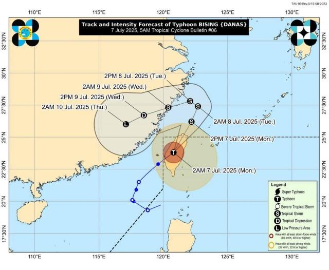
The typhoon slightly weakened as it moved over the northwestern portion of Taiwan at 25 km/h northeastward.
From Bising's center, strong to typhoon-force winds are extending outwards up to 390 km.
No Tropical Cyclone Wind Signals were raised.
Bising re-entered PAR at 11 p.m. Sunday and made landfall over Taiwan's southwestern portion at 11:50 p.m.
Habagat
PAGASA said the Southwest Monsoon will bring strong to gale-force gusts today over the Ilocos Region, Cagayan, Isabela, Aurora, Zambales, Bataan, Quezon, Occidental Mindoro, Masbate, and Romblon, especially in coastal and upland areas exposed to winds.
Ilocos Norte, Ilocos Sur, La Union, and Pangasinan will also have 50-100 mm of rainfall today.
"Forecast rainfall maybe higher in mountainous and elevated areas. Moreover, impacts in some areas maybe worsened by significant antecedent rainfall," PAGASA said.
Coastal waters
The weather bureau said moderate to rough seas will prevail in the seaboard of Batanes and the western and northern seaboards of Babuyan Islands, with waves reaching up to 4 meters.
Up to 3-meter tall waves will be seen in the western seaboard of Ilocos Norte.
"Mariners of small seacrafts, including all types of motorbancas, are advised not to venture out to sea under these conditions, especially if inexperienced or operating ill-equipped vessels," PAGASA said.
Meanwhile, up to moderate seas will prevail over the following coastal waters:
- The seaboard of Zambales, and the remaining seaboards of Ilocos Region and Babuyan Islands: up to 2.5 meters
- The seaboards of Bataan and Lubang Islands.: Up to 2.0 meters.
"Mariners of motorbancas and similarly-sized vessels are advised to take precautionary measures while venturing out to sea and, if possible, avoid navigation under these conditions," PAGASA said.
The next bulletin will be issued by PAGASA at 11 a.m.
Classes
Meanwhile, classes for Monday, July 7, 2025 have been canceled in some areas due to the effects of the Habagat and recent rains. —KG, GMA Integrated News
