

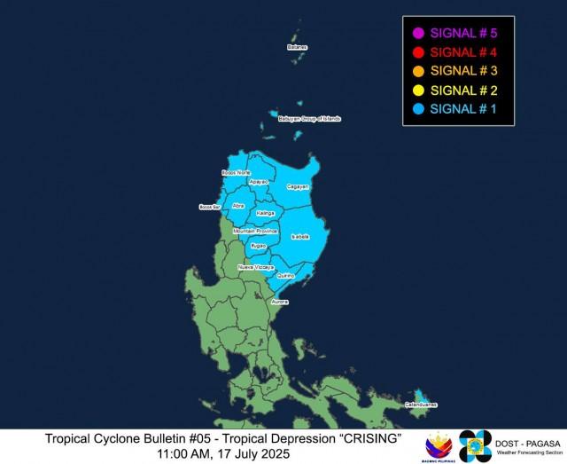
14 areas under Signal No. 1 as Crising may landfall over Cagayan
State weather bureau PAGASA on Thursday said 14 areas in Luzon are under Tropical Cyclone Wind Signal (TCWS) No. 1 as Tropical Depression Crising is expected to make landfall over Cagayan on Friday or Saturday.
In its 11 a.m. bulletin, PAGASA said TCWS No. 1 is hoisted in the following areas:
- Southern portion of Batanes (Sabtang, Ivana, Uyugan, Mahatao, Basco)
- Cagayan including Babuyan Islands
- Isabela
- Quirino
- Northeastern portion of Nueva Vizcaya (Kasibu, Quezon, Bagabag, Diadi, Bayombong, Solano, Ambaguio, Villaverde)
- Northern portion of Aurora (Dilasag, Casiguran, Dinalungan, Dipaculao)
- Apayao
- Abra
- Kalinga
- Mountain Province
- Ifugao
- Ilocos Norte
- Northern portion of Ilocos Sur (City of Vigan, Santa, Caoayan, Bantay, Nagbukel, Narvacan, Cabugao, San Juan, Sinait, Magsingal, San Ildefonso, Santo Domingo, San Vicente, Santa Catalina)
- Northern and eastern portions of Catanduanes (Pandan, Bagamanoc, Panganiban, Viga, Gigmoto)
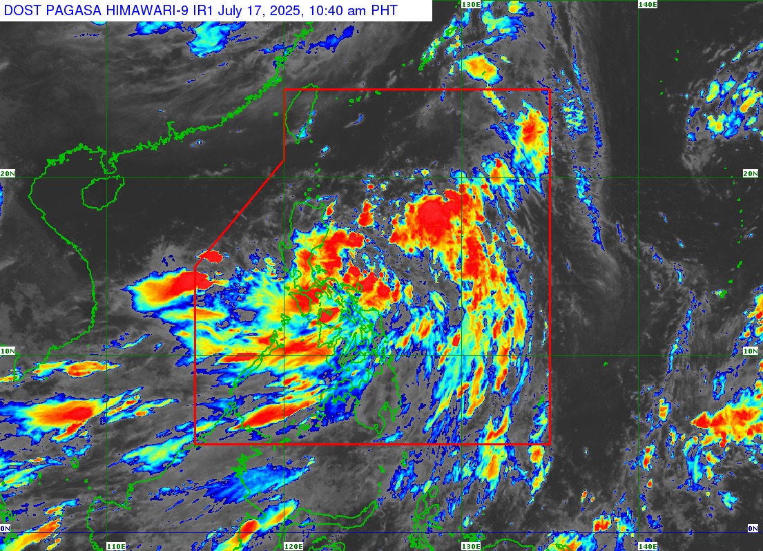
Crising was kast located 520 kilometers east northeast of Juban, Sorsogon or 470 km east northeast of Virac, Catanduanes.
The tropical depression was packing maximum sustained winds of 55 km per hour (kph) near the center and gustiness of up to 70 kph.Crising was moving north northwestward at 25 km/h.
“A landfall scenario over mainland Cagayan tomorrow (18 July) evening to Saturday (19 July) early morning is possible,” PAGASA said.
“Afterwards, it will move westward traversing the northern portion of Northern Luzon, and turn west northwestward until it exits the Philippine Area of Responsibility by Saturday evening or Sunday (20 July) morning,” it added.
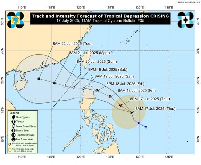
PAGASA also said that Crising may reach the tropical storm category.
“It is forecast to continue intensifying over the Philippine Sea and may reach Severe Tropical Storm category tomorrow afternoon or evening before its approach to Northern Luzon,” PAGASA said.
Based on the recent heavy rainfall outlook, PAGASA said Crising will bring rainfall of 100 to 200 millimeters in Camarines Norte, Camarines Sur, and Catanduanes from Thursday to Friday noon.
Rainfall of 50 to 100 millimeters may be experienced over Cagayan, Isabela, Quirino, Aurora, Quezon, Albay, Sorsogon, Masbate, Northern Samar, Eastern Samar, Samar, and Biliran.
“Forecast rainfall may be higher in mountainous and elevated areas. Moreover, impacts in some areas may be worsened by significant antecedent rainfall,” PAGASA said.
“The public and disaster risk reduction and management offices concerned are advised to take all necessary measures to protect life and property,” it added.
Minimal to moderate risk of life-threatening storm surge with peak heights reaching 1.0 to 2.0 meters are possible over Cagayan including Babuyan Islands and Isabela in the next 48 hours.
Habagat
Meanwhile, PAGASA also said that Habagat or the Southwest Monsoon will bring strong to gale-force gusts over Batangas, Quezon, the rest of Bicol, MIMAROPA, Visayas, Zamboanga del Norte, Camiguin, Surigao del Norte, Dinagat Islands, Davao Occidental, Davao Oriental, and Sarangani.
Rough seas of up to 3.0 m are expected in the eastern seaboards of Batanes, Babuyan Islands, mainland Cagayan, Isabela, and northern Aurora; the western seaboards of Palawan.
“Mariners of small seacrafts, including all types of motorbancas, are advised not to venture out to sea under these conditions, especially if inexperienced or operating ill-equipped vessels,” PAGASA said.
Moderate seas of up to 2.5 m may be experienced in the remaining seaboards of Batanes, Babuyan Islands, mainland Cagayan, and Palawan.
The same sea condition is also possible in the northern and western seaboards of Zamboanga del Norte and Camiguin; the southern seaboards of Antique, Iloilo, Guimaras, Negros Occidental, Negros Oriental, Siquijor, Bohol and Southern Leyte.
Also affected are the eastern seaboards of Davao Region; and the seaboards of Surigao del Norte and Dinagat Islands.
Up to 2.0 meters of moderate seas are also expected over the western seaboard of Occidental Mindoro and Romblon; the northwestern seaboard of Masbate, the remaining seaboards of Aurora, Catanduanes and Antique.
The same sea condition will be experienced in the northern and eastern seaboards of Polillo Islands; the northern seaboards of Camarines Norte and Camarines Sur; and the eastern seaboards of Northern and Eastern Samar.
“Mariners of motorbancas and similarly-sized vessels are advised to take precautionary measures while venturing out to sea and, if possible, avoid navigation under these conditions,” PAGASA said. —VAL, GMA Integrated News
