

Signal No. 2 remains over 10 areas in Luzon due to Crising
Ten areas in Luzon are still under Signal No. 2 as Tropical Storm Crising continues to move towards mainland Cagayan, state weather bureau PAGASA reported Friday afternoon.
According to PAGASA's 2 p.m. cyclone bulletin, the following areas will experience gale-force winds of 62 to 88 kph over the next 24 hours:
- Batanes
- Cagayan including Babuyan Islands
- Isabela
- Apayao
- Kalinga
- Northern and central portions of Abra (Manabo, Pidigan, San Juan, Tayum, Langiden, Boliney, Sallapadan, Bucloc, Lagangilang, Danglas, La Paz, Licuan-Baay, Tineg, Malibcong, Peñarrubia, San Isidro, Daguioman, San Quintin, Dolores, Lagayan, Bangued, Bucay, Lacub)
- Eastern portion of Mountain Province (Natonin, Paracelis)
- Eastern portion of Ifugao (Aguinaldo, Alfonso Lista)
- Ilocos Norte
- Northern portion of Ilocos Sur (Cabugao, Sinait, Magsingal, San Juan, San Ildefonso, Santo Domingo, Bantay, San Vicente, Santa Catalina, Caoayan, City of Vigan, Santa)
Ten other areas have been placed under Signal No. 1 and may have strong winds of 39 to 61 kph over the next 36 hours:
- Quirino
- Nueva Vizcaya
- The rest of Mountain Province
- The rest of Ifugao
- The rest of Abra, Benguet
- The rest of Ilocos Sur
- La Union
- Northern portion of Pangasinan (San Nicolas, Natividad, San Quintin, San Manuel, Tayug, Sison, San Fabian, Pozorrubio, Laoac, Binalonan, San Jacinto, Manaoag, Mangaldan, Dagupan City, Binmaley, Lingayen, Labrador, Sual, City of Alaminos, Bolinao, Anda, Bani, Agno, Burgos, Mabini, Dasol, Calasiao, Santa Barbara, Mapandan, Bugallon)
- Northern portion of Aurora (Dilasag, Casiguran, Dinalungan, Dipaculao, Baler, Maria Aurora)
- Northeastern portion of Nueva Ecija (Carranglan, Pantabangan)
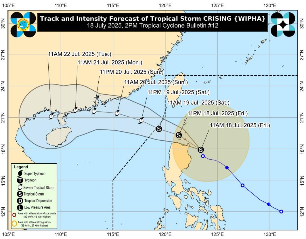
Tropical Storm Crising was last located at 135 kilometers east northeast of Tuguegarao City, Cagayan.
Crising packs maximum sustained winds of 75 kph and gusts of up to 90 kph.
PAGASA warned of heavy rainfall, gale-force winds enhanced by the monsoon, risks of storm surges, and rough sea conditions in several affected areas nationwide.
A gale warning has also been hoisted over the northern seaboard of Northern Luzon.
Landfall on Friday
Meanwhile, minimal to moderate risk of storm surge with estimated heights of 1 to 2 meters was predicted in Batanes, Cagayan, Ilocos Norte, and Ilocos Sur.
Crising will continue to move northwestward within the next 12 hours.
It may make landfall over mainland Cagayan or the Babuyan Islands by Friday afternoon or evening.
It is predicted to intensify into a Severe Tropical Storm by Friday afternoon, and exit the Philippine Area of Responsibility (PAR) at about the same time.
Potential threats
PAGASA is also monitoring the activity of Tropical Depression Crising and several tropical cyclone-like vortices that may develop into cyclones inside the PAR over the next two weeks.
In its 2 p.m. threat potential forecast, PAGASA said Crising continues to move towards the northern Luzon area, while a tropical cyclone-like vortex may possibly form near northern Luzon within PAR.
The said vortex has a high chance of developing into a cyclone within the forecast period of July 18 to 25.
In the following days of July 26 to 31, this vortex is expected to move towards Taiwan-Ryuku as another one forms inside the PAR and the Tropical Cyclone Advisory Domain (TCAD), with a low chance of becoming a cyclone.
A third vortex is expected to develop within the PAGASA Monitoring Domain (PMD), and may possibly be the remnants of Tropical Storm Crising. — VDV, GMA Integrated News
