

Emong intensifies as 2 areas under Signal No.3; Dante maintains strength
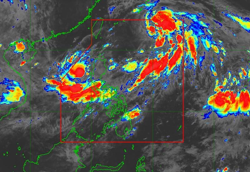
Severe Tropical Storm Emong moving southwestward over the sea west of the Ilocos Region with Signal No. 3 raised over two areas while Tropical Storm Dante maintains its strength with no signals raised, according to the 5 a.m. Tropical Cyclone Bulletin posted by PAGASA.
The center of the Emong was estimated at 245 kilometers eest of Bacnotan, La Union packing maximum winds of 110 kilometers per hour, gustiness of up to 135 kph and moving southwestward at the speed of 25 kph.
Tropical Cyclone Wind Signal (TCWS) No. 3 is hoisted over the following areas:
- the northern portion of Pangasinan (Anda, Bolinao, Bani)
- the western portion of La Union (Luna, Balaoan, Bacnotan, San Juan, City of San Fernando, Bauang, Caba)
TCWS Signal No. 2 is raised over the following areas:
- Ilocos Norte
- Ilocos Sur
- the rest of La Union
- the western portion of Apayao (Conner, Kabugao, Calanasan)
- Abra
- Kalinga
- Mountain Province
- Ifugao
- Benguet
- the central portion of Pangasinan (Agno, Burgos, Mabini, City of Alaminos, Sual, Labrador, Bugallon, Infanta, Dasol, Lingayen, Binmaley, Dagupan City, Calasiao, Santa Barbara, Mangaldan, Mapandan, Manaoag, Laoac, Binalonan, San Manuel, San Nicolas, Pozorrubio, Sison, San Fabian, San Jacinto),
- the western portion of Nueva Vizcaya (Kayapa, Santa Fe)
TCWS No. 1 is raised over the following areas:
- Batanes
- Cagayan including Babuyan Islands
- the western and central portions of Isabela (Santo Tomas, Delfin Albano, Quezon, Mallig, Quirino, Roxas, San Manuel, Aurora, San Mateo, Ramon, Cordon, Burgos, Cabatuan, Cabagan, San Pablo, Santa Maria, Tumauini, Gamu, Luna, Maconacon, Alicia, San Mariano, Naguilian, San Guillermo, City of Cauayan, Echague, Ilagan City, Angadanan, Benito Soliven, City of Santiago, Reina Mercedes, San Agustin, Divilacan, San Isidro, Jones)
- the rest of Nueva Vizcaya
- Quirino
- the rest of Apayao
- the rest of Pangasinan
- the northern and central portions of Zambales (Santa Cruz, Candelaria, Masinloc, Palauig, Iba, Botolan, Cabangan)
- Tarlac
- the western and central portions of Nueva Ecija (Carranglan, Lupao, Talugtug, Cuyapo, Nampicuan, Guimba, Science City of Muñoz, San Jose City, Pantabangan, Rizal, Llanera, Talavera, Santo Domingo, Quezon, Licab, Aliaga, Zaragoza, San Antonio, Jaen, Cabanatuan City, Santa Rosa, General Mamerto Natividad, Palayan City, Bongabon, Laur)
Meanwhile, Tropical Storm Dante maintains its strength as it continues to move northwestward towards Ryukyu Islands.
The center of Tropical Storm Dante was estimated at 790 kilometers east Northeast of Itbayat, Batanes packing maximum sustained winds of 75 kilometers per hour near the center, gustiness of up to 90 km/h, and central pressure of 994 hPa.
Dante is moving north northwestward at the speed of 15 kph.
There will be strong to gale-force winds that extend outwards up to 550 km, but there are no wind signals currently raised.
Enhanced Southwest Monsoon
PAGASA reported that the enhanced Southwest Monsoon will bring strong to gale-force gusts over the following areas (especially in coastal and upland areas exposed to winds): Metro Manila, the rest of Central Luzon, CALABARZON, Bicol Region, MIMAROPA, Visayas, Zamboanga del Norte, Misamis Occidental, Lanao del Norte, Camiguin, Dinagat Islands, and Davao Oriental.
A Gale Warning is in effect over the western seaboards of Luzon, the state weather bureau added.
"Emong is forecast to move generally southeastward before turning north northeastward in the next 24 hours. On the forecast track, Emong may pass close to Pangasinan this afternoon and may make landfall over Ilocos Region tonight or tomorrow early morning. After traversing the Northern Luzon, the center of EMONG will re-emerge over the Luzon Strait and may pass close to Babuyan Islands," PAGASA said.
"Emong intensified into a severe tropical storm at 2:00 AM today. Further intensification into typhoon is possible prior to its landfall," the agency added.
