

Signal No. 3 still up in Pangasinan, La Union due to Emong
Tropical Cyclone Wind Signal (TCWS) No. 3 is still hoisted over two areas as Typhoon Emong is seen to make a close approach over Pangasinan, state weather bureau PAGASA said on Thursday.
In its 11 a.m. bulletin, PAGASA raised the following storm signal warnings:
Signal No. 3
- The northern portion of Pangasinan (Anda, Bolinao, Bani)
- The western portion of La Union (Luna, Balaoan, Bacnotan, San Juan, City of San Fernando, Bauang, Caba)
Signal No. 2
- Ilocos Norte
- Ilocos Sur
- the rest of La Union
- the western portion of Apayao (Conner, Kabugao, Calanasan)
- Abra
- Kalinga
- Mountain Province
- Ifugao
- Benguet
- The central portion of Pangasinan (Agno, Burgos, Mabini, City of Alaminos, Sual, Labrador, Bugallon, Infanta, Dasol, Lingayen, Binmaley, Dagupan City, Calasiao, Santa Barbara, Mangaldan, Mapandan, Manaoag, Laoac, Binalonan, San Manuel, San Nicolas, Pozorrubio, Sison, San Fabian, San Jacinto),
- The western portion of Nueva Vizcaya (Kayapa, Santa Fe)
Signal No. 1
- Batanes
- Cagayan including Babuyan Islands
- The western and central portions of Isabela (Santo Tomas, Delfin Albano, Quezon, Mallig, Quirino, Roxas, San Manuel, Aurora, San Mateo, Ramon, Cordon, Burgos, Cabatuan, Cabagan, San Pablo, Santa Maria, Tumauini, Gamu, Luna, Maconacon, Alicia, San Mariano, Naguilian, San Guillermo, City of Cauayan, Echague, Ilagan City, Angadanan, Benito Soliven, City of Santiago, Reina Mercedes, San Agustin, Divilacan, San Isidro, Jones)
- The rest of Nueva Vizcaya
- Quirino
- The rest of Apayao
- The rest of Pangasinan
- The northern and central portions of Zambales (Santa Cruz, Candelaria, Masinloc, Palauig, Iba, Botolan, Cabangan)
- Tarlac
- The western and central portions of Nueva Ecija (Carranglan, Lupao, Talugtug, Cuyapo, Nampicuan, Guimba, Science City of Muñoz, San Jose City, Pantabangan, Rizal, Llanera, Talavera, Santo Domingo, Quezon, Licab, Aliaga, Zaragoza, San Antonio, Jaen, Cabanatuan City, Santa Rosa, General Mamerto Natividad, Palayan City, Bongabon, Laur)
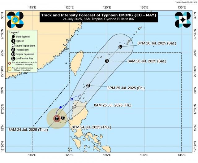
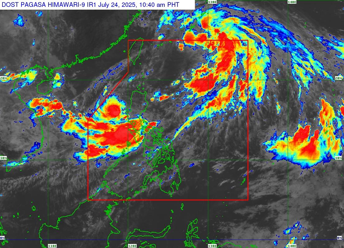
Emong was last located 220 kilometers west southwest of Bacnotan, La Union or 210 km west of Dagupan City, Pangasinan.
The typhoon was packing maximum sustained winds of 120 km per hour (kph) near the center and gustiness of up to 150 km/h
Emong was moving south southeastward slowly.
“The typhoon will then accelerate northeastward tonight and make landfall over La Union or Ilocos Sur tomorrow (25 July) morning. A close approach over northwestern Pangasinan between this evening and tomorrow early morning prior to landfall further north is not ruled out,” PAGASA said.
“After briefly crossing the mountainous terrain of northwestern Luzon, EMONG will continue accelerating northeastward over Luzon Strait and the Philippine Sea east of Taiwan. Between tomorrow late morning and evening, it may pass close or make landfall over Babuyan Islands and Batanes,” it added.
PAGASA said Emong may still briefly intensify prior to landfall due to favorable atmospheric and oceanic environments.
A landfall scenario as a typhoon remains the more likely scenario, according to PAGASA.
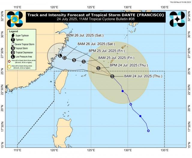
Meanwhile, Tropical Storm Dante was spotted 735 km east northeast of Itbayat, Batanes, packing maximum sustained winds of 75 kph near the center and gustiness of up to 90 kph.
Dante was moving north northwestward at 30 kph.
The tropical storm may move generally west northwestward as it approaches Ryukyu Islands and west northwestward to westward as it moves over the East China Sea.
“On the track forecast, DANTE may exit the Philippine Area of Responsibility (PAR) this afternoon or evening,” PAGASA said.
“DANTE is forecast to remain as a tropical storm as it exits the Philippine Area of Responsibility (PAR). It is then expected to weaken over the East China Sea by the weekend due to unfavorable conditions,” it added.
Rainfall
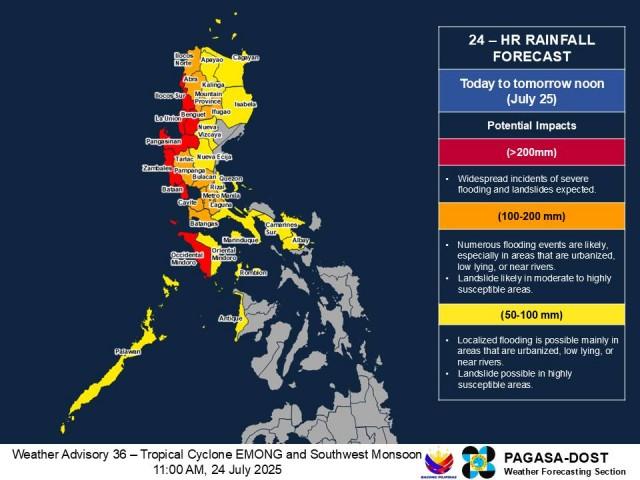
The combined effects of Dante, Emong, and the Southwest Monsoon or Habagat are bringing heavy rains in different parts of the country.
Due to Emong, rainfall of over 200 millimeter is expected over Ilocos Sur, La Union, Pangasinan, Zambales, and Benguet from Thursday to Friday noon, according to PAGASA's 11 a.m. advisory.
Rainfall from 100-200 mm may be experienced in Ilocos Norte, Tarlac, Abra, Mountain Province, and Ifugao.
Also, 50-100 mm of rainfall is expected over Cagayan, Kalinga, Apayao, Isabela, Nueva Vizcaya, and Nueva Ecija.
Habagat, which is enhanced by Dante and Emong, will also bring over 200 mm of rainfall in Bataan and Occidental Mindoro from Thursday to Friday noon.
Rainfall from 100-200 mm is expected over Metro Manila, Pampanga, Bulacan, Cavite, Batangas, Laguna, and Rizal.
Meanwhile, 50-100 mm of rainfall in Quezon, Oriental Mindoro, Palawan, Marinduque, Romblon, Antique, Camarines Sur, and Albay.
“Forecast rainfall may be higher in mountainous and elevated areas. Moreover, impacts in some areas may be worsened by significant antecedent rainfall,” PAGASA said.
“The public and disaster risk reduction and management offices concerned are advised to take all necessary measures to protect life and property,” it added.
Impact
Twelve people have been reported dead due to the impact of Tropical Cyclone Crising and the Southwest Monsoon or Habagat, according to the Philippine National Police on Wednesday.
Citing information from PNP public information office chief Police Brigadier General Randulf Tuaño, Super Radyo dzBB’s Mark Makalalad reported on Dobol B TV that most of the reported deaths were recorded in Calabarzon with five.
This was followed by Negros Island Region with three.
One fatality was reported each in Metro Manila, Mimaropa, Northern Mindanao, and Bangsamoro Autonomous Region in Muslim Mindanao (BARRM).
The victims died due to drowning and falling trees.
Meanwhile, Makalalad said that based on the same information, nine people were reported missing and seven others were reported injured.
The information from the PNP is up for validation by the National Disaster Risk Reduction and Management Council (NDRRMC).
Class cancellations
Classes at all levels and government work on Thursday, July 24, in parts of Luzon and Visayas have been suspended due to inclement weather.
METRO MANILA
ILOCOS REGION
1. Ilocos Norte
2. Ilocos Sur
3. La Union
4. Pangasinan
CAGAYAN VALLEY
1. Cagayan
2. Nueva Vizcaya
CORDILLERA ADMINISTRATIVE REGION
1. Abra
2. Apayao
3. Benguet
4. Ifugao
5. Kalinga
6. Mountain Province
CENTRAL LUZON
1. Bataan
2. Bulacan
3. Nueva Ecija
4. Pampanga
5. Tarlac
6. Zambales
CALABARZON
1. Cavite
2. Quezon
3. Batangas
4. Laguna
5. Rizal
MIMAROPA
1. Marinduque
2. Occidental Mindoro
3. Oriental Mindoro
4. Palawan
5. Romblon
BICOL REGION
1. Albay
2. Camarines Sur
3. Catanduanes
4. Sorsogon
5. Masbate
WESTERN VISAYAS
1. Antique
2. Iloilo
State of CalamityA total of 40 cities and municipalities have declared a state of calamity as of Thursday morning due to the impact of Tropical Cyclones Crising, Dante, and Emong as well as the Southwest Monsoon or Habagat.
In its 6 a.m. report on Thursday, the National Disaster Risk Reduction and Management Council (NDRRMC) said these areas include the entire province of Cavite covering 23 cities and municipalities, as well as 17 areas in other provinces and Metro Manila. These are:
Cavite province
Mangaldan, Umingan in Pangasinan
Meycauayan, Paombong, Balagtas (Bigaa), and Calumpit in Bulacan
Masantol, Pampanga
Paniqui, Tarlac
Agoncillo, Batangas
San Mateo, Rodriguez (Montalban), and Cainta in Rizal
Roxas, Palawan
Barbaza and Sebaste in Antique
Malabon City
Quezon City
Aside from these 40 areas, GMA Integrated News' Saksi on Wednesday reported nine other areas under a state of calamity including:
Marikina, Manila, and Las Piñas in Metro Manila
Dagupan City, Calasiao, Lingayen, Malasiqui, and Sta. Barbara in Pangasinan
Cebu City
A total of 2,733,646 people or 765,869 families have been affected by the bad weather in all regions except Eastern Visayas.
Floods, landslides, collapsed structures, and tornadoes were reported in the affected areas. —VAL, GMA Integrated News
