

Emong nears landfall over western Pangasinan
Signal No. 4 was hoisted over three areas in Luzon as Typhoon Emong neared landfall over western Pangasinan, PAGASA said Thursday evening.
According to PAGASA's 8 p.m. bulletin, the following areas are under Signal No. 4:
- the southwestern portion of Ilocos Sur (Santa Lucia, Santa Cruz, Tagudin)
- the northwestern portion of La Union (Bangar, Luna, Balaoan, Bacnotan, San Juan, City of San Fernando, Bauang)
- the extreme northwestern portion of Pangasinan (Agno, Bani, Bolinao, Anda, City of Alaminos)
Signal No. 3 is up in the following areas:
- the southern portion of Ilocos Norte (Laoag City, San Nicolas, Sarrat, Dingras, Solsona, Nueva Era, City of Batac, Marcos, Paoay, Currimao, Banna, Pinili, Badoc)
- the rest of Ilocos Sur, the rest of La Union
- the northern and western portions of Pangasinan (Burgos, Dasol, Mabini, Lingayen, Bugallon, Infanta, Labrador, Sual, Dagupan City, San Fabian, Binmaley)
- Abra
- the western portion of Mountain Province (Besao, Tadian, Sagada, Bauko)
- the western portion of Benguet (Sablan, Kapangan, Mankayan, Tuba, Bakun, Kibungan)
Signal No. 2 was hoisted over the following areas:
- the rest of Ilocos Norte
- the rest of Pangasinan
- Apayao
- Kalinga
- the rest of Mountain Province
- Ifugao
- the rest of Benguet
- Babuyan Islands
- the northern and western portions of mainland Cagayan (Rizal, Santa Praxedes, Claveria, Sanchez-Mira, Pamplona, Abulug, Ballesteros, Aparri, Camalaniugan, Allacapan, Buguey, Santa Teresita, Santa Ana, Gonzaga, Lal-Lo, Lasam, Santo Niño, Piat, Tuao)
- the western portion of Nueva Vizcaya (Kayapa, Santa Fe, Ambaguio, Aritao, Bambang, Bayombong, Villaverde, Solano, Bagabag)
- the northern portion of Zambales (Masinloc, Candelaria, Santa Cruz, Palauig, Iba)
The following areas are under Signal No. 1:
- Batanes
- the rest of Cagayan
- the western and central portions of Isabela (Santo Tomas, Delfin Albano, Quezon, Mallig, Quirino, Roxas, San Manuel, Aurora, San Mateo, Ramon, Cordon, Burgos, Cabatuan, Cabagan, San Pablo, Santa Maria, Tumauini, Gamu, Luna, Maconacon, Alicia, San Mariano, Naguilian, San Guillermo, City of Cauayan, Echague, Ilagan City, Angadanan, Benito Soliven, City of Santiago, Reina Mercedes, San Agustin, Divilacan, San Isidro, Jones)
- Quirino
- the rest of Nueva Vizcaya
- the rest of Zambales
- the northern portion of Bataan (Dinalupihan, Hermosa, Morong)
- Tarlac
- the northern portion of Pampanga (Porac, Floridablanca, Angeles City, Mabalacat City, Magalang)
- the western and central portions of Nueva Ecija (Carranglan, Lupao, Talugtug, Cuyapo, Nampicuan, Guimba, Science City of Muñoz, San Jose City, Pantabangan, Rizal, Llanera, Talavera, Santo Domingo, Quezon, Licab, Aliaga, Zaragoza, San Antonio, Jaen, Cabanatuan City, Santa Rosa, General Mamerto Natividad, Palayan City, Bongabon, Laur)
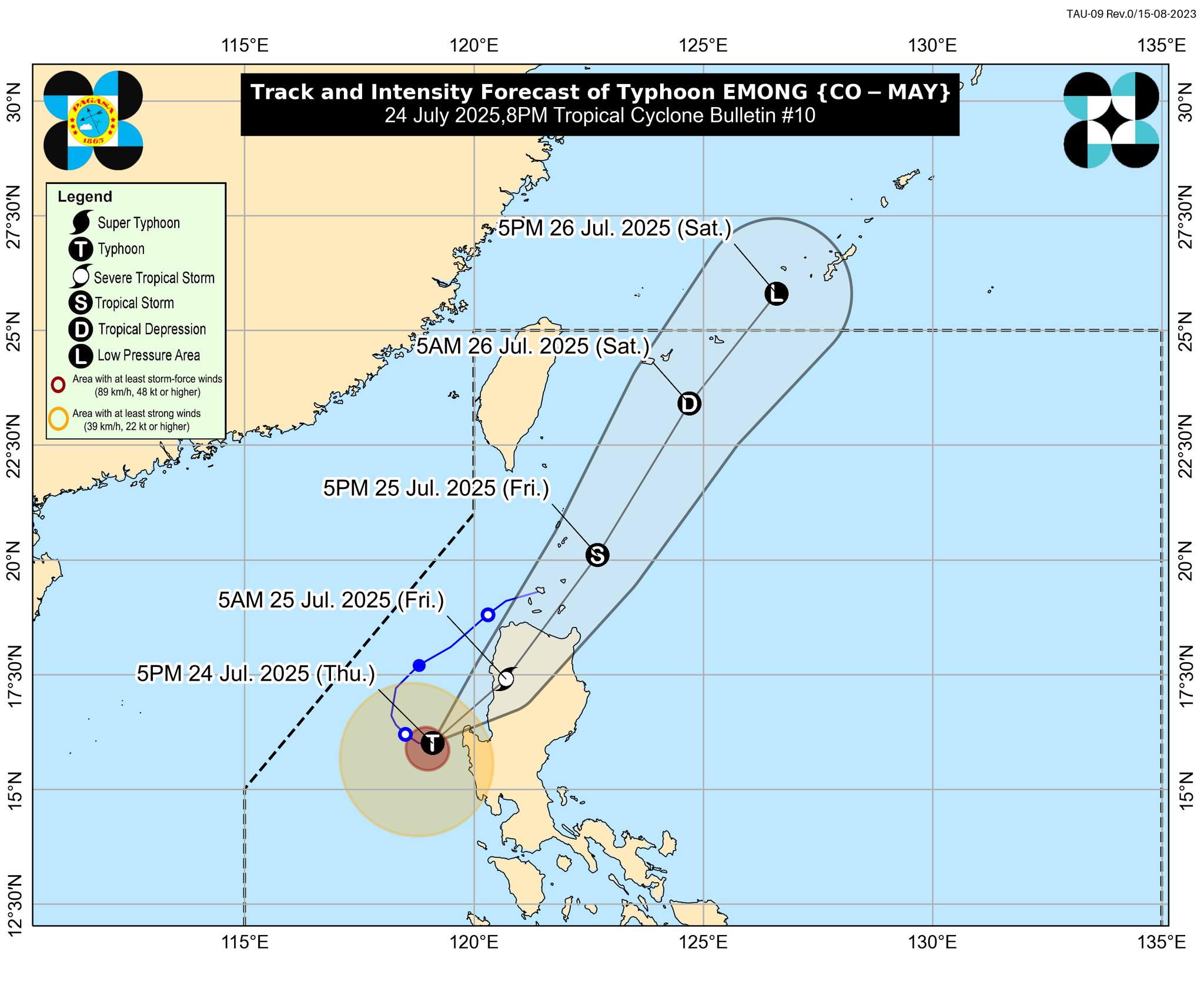
At 7 p.m., Emong was monitored over the coastal waters of Burgos, Pangasinan, carrying maximum sustained winds of 120 km/h near the center and gustiness of up to 165 km/h.
It was moving eastward slowly.
“On the track forecast, the typhoon will make landfall or pass very close to western Pangasinan in the next 3 hours,” PAGASA said.
“The typhoon may also make landfall in La Union or Ilocos Sur this late evening or tomorrow early morning,” it added.
State meteorologists also said Emong may still briefly intensify prior to landfall due to its compact circulation and favorable atmospheric and oceanic environment.
“While a landfall scenario as a typhoon remains the more likely scenario, a slight weakening prior to landfall due to increasing interaction with the terrain of northwestern Luzon is not ruled out,” PAGASA said.
“Nevertheless, the passage of Emong will trigger a weakening trend, which is expected to continue for the rest of the forecast period,” it added.
After landfall, Emong is expected to cross the mountainous terrain of Northern Luzon and emerge over the Babuyan Channel on Friday morning or noon.
Emong will then move northeastward and pass close or over Babuyan Islands between Friday noon and afternoon. It may also be passing near Batanes between Friday afternoon or evening.
The Southwest Monsoon will bring strong to gale-force gusts over Central Luzon (areas not under wind signal), Metro Manila, CALABARZON, Bicol Region, MIMAROPA, Visayas, Zamboanga del Norte, Misamis Occidental, Lanao del Norte, and Camiguin on Friday.
A moderate to high risk of life-threatening storm surge with peak heights reaching 1.0 to 3.0 m is expected within 24 hours over the low-lying or exposed coastal localities of Batanes, northern mainland Cagayan, Babuyan Islands, Ilocos Norte, Ilocos Sur, La Union, Pangasinan, and Zambales.
A gale warning is also in effect over the seaboards of Northern Luzon and the western seaboards of Central and Southern Luzon. —Mariel Celine Serquiña/VBL, GMA Integrated News
