

LPA east of Surigao del Sur may intensify, will be called Jacinto —PAGASA
A low pressure area (LPA) located east of Surigao del Sur may intensify and become a tropical depression on Sunday, PAGASA said. If it does, it will be called Jacinto.
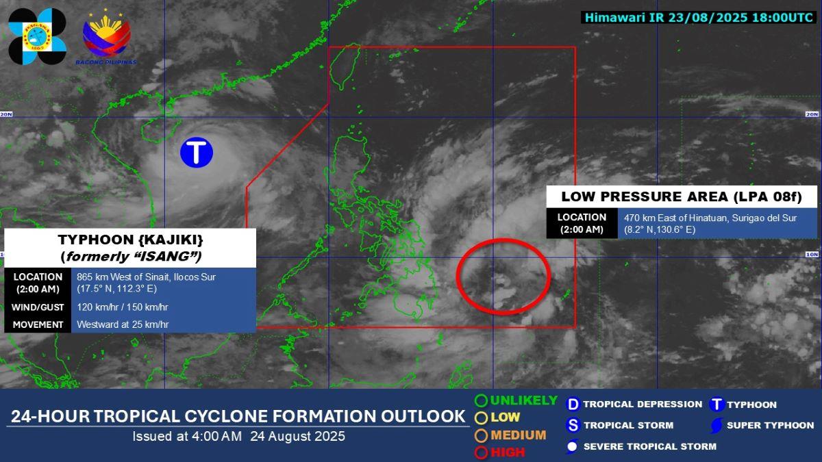
The LPA was estimated to be located at 3 a.m. at 445 km of Hinatuan, Surigao del Sur.
"Base sa mga pinakahuling datos ay may tsansa itong maging bagyo partikular na sa araw na ito," DOST-PAGASA weather specialist Obed Badrina said in the weather bureau's public weather forecast.
The LPA is moving toward Visayas and Mindanao, he added.
Eastern Visayas, Central Visayas, Caraga, Northern Mindanao, and Davao Region will have cloudy skies with scattered rains and thunderstorms on Sunday due to the LPA. Flash floods or landslides may result due to moderate to at times heavy rains.
According to the outlook of PAGASA, the LPA or Jacinto will move generally west northwestward on Monday and may affect Visayas and Mindanao, bringing moderate to at times heavy rains. Raising of Tropical Cyclone Wind Signal is possible.
In its weather advisory issued at 11 a.m., PAGASA said Masbate, Albay, Sorsogon, Biliran, Eastern Samar, Leyte, Northern Samar, Samar, Southern Leytecentr, Bohol, Cebu, Agusan del Norte, Agusan del Sur, Dinagat Islands, Surigao del Norte, and Surigao del Sur will have 50 to 100 mm of rainfall on Sunday up to Monday noontime.
Habagat
Meanwhile, the Southwest Monsoon (Habagat) slightly weakened, Badrina said.
Palawan may expect partly cloudy to cloudy skies with isolated rain showers or thunderstorms on Sunday due to the monsoon. During severe thunderstorms, flash floods or landslides may result.
Metro Manila and the rest of the country on the other hand will have generally fair weather with partly cloudy to cloudy skies with isolated rain showers or thunderstorms due to localized thunderstorms. Flash floods or landslides may possibly occur during severe thunderstorms.
Coastal waters will be slight to moderate throughout the country. No gale warning was raised, PAGASA said.
Sunrise was at 5:43 a.m. while sunset will be at 6:14 p.m.
Isang
Meanwhile, what was known as Tropical Storm Isang exited the Philippine Area of Responsibility on Saturday morning and is now Typhoon Kajiki.
As of 3 a.m., Kajiki was located 900 km west of Northern Luzon, packing maximum sustained winds of 120 km/h near the center with gustiness of up to 150 km/h.
Kajiki is moving westward at 25 km/h.
"Wala na itong direktang epekto pa or even indirect effect sa anumang bahagi ng bansa," Badrina said.
(It no longer has a direct or even indirect effect on any part of the country.) —KG, GMA Integrated News
