

6 areas under Signal No. 2; Nando now super typhoon
Six areas are now under Signal No.2 as Super Typhoon Nando continues to draw closer to northern Luzon on Sunday morning.
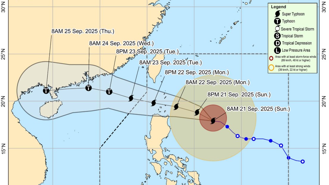
According to its 11:00 a.m. tropical cyclone bulletin, PAGASA said the center of the eye of Super Typhoon Nando (international name: Ragasa) was estimated based on all available data at 535 km East of Tuguegarao City, Cagayan as of 10 a.m.
The state weather bureau said Nando carries maximum sustained winds of 185 km/h near the center, gustiness of up to 230 km/h, and central pressure of 930 hPa
The super typhoon is moving westward at 15 km/h. It has strong to typhoon-force winds extend outwards up to 530 km from the center.
Tropical Cyclone Wind Signal (TCWS) No.2 has been raised over the following areas:
- Batanes
- Cagayan including Babuyan Islands,
- The northern and eastern portions of Isabela (San Mariano, Ilagan City, Tumauini, Cabagan, Palanan, Divilacan, Maconacon, San Pablo, Santa Maria, Santo Tomas, Delfin Albano, Quezon)
- Apayao
- The eastern portion of Kalinga (Rizal, City of Tabuk, Pinukpuk)
- The northern portion of Ilocos Norte (Vintar, Carasi, Adams, Dumalneg, Pagudpud, Bangui, Burgos, Pasuquin)
Areas under TCWS No.1 are:
- The rest of Isabela
- Quirino
- Nueva Vizcaya
- The rest of Kalinga
- Abra
- Mountain Province
- Ifugao
- Benguet
- The rest of Ilocos Norte
- Ilocos Sur
- La Union
- Pangasinan
- The northern portion of Zambales (Santa Cruz, Candelaria, Masinloc, Palauig)
- The northern and central portions of Nueva Ecija (Carranglan, Lupao, San Jose City, Pantabangan, Bongabon, Laur, Gabaldon, General Mamerto Natividad, Rizal, Llanera, Talavera, Science City of Muñoz, Santo Domingo, Talugtug, Palayan City, Cuyapo, Nampicuan, Guimba, Licab, Quezon, Aliaga, Cabanatuan City, Santa Rosa, Zaragoza, Jaen, San Leonardo, General Tinio, Peñaranda)
- The northern and central portions of Tarlac (San Jose, City of Tarlac, La Paz, Victoria, Gerona, Paniqui, Moncada, San Manuel, Anao, Ramos, Pura, Camiling, San Clemente, Mayantoc, Santa Ignacia)
- Aurora
PAGASA also issued a heavy rainfall outlook due to Tropical Cyclone Nando and the Southwest Monsoon or Habagat.
"Nando will begin to turn west northwestward today, moving towards Extreme Northern Luzon. On the forecast track, the center of Nando may pass close or may make landfall over Batanes or Babuyan Islands by tomorrow (22 September) afternoon or evening. It may exit the Philippine Area of Responsibility by Tuesday (23 September) early morning," PAGASA said.
It added the super typhoon is forecast to further intensify before it approaches Extreme Northern Luzon.
For wind strength, meteorologists said "the wind signals warn the public of the general wind threat over an area due to the tropical cyclone. Local winds may be slightly stronger/enhanced in coastal and upland/mountainous areas exposed to winds. Winds are less strong in areas sheltered from the prevailing wind direction."
Weather specialists said the highest Wind Signal that may be hoisted throughout the passage of Nando is Wind Signal No. 5.PAGASA said the Southwest Monsoon and the trough of Nando will bring strong to gale-force gusts over the following areas (especially in coastal and upland areas exposed to winds):
• Sept.21: Metro Manila, Central Luzon (areas not under wind signal), CALABARZON, Bicol Region, MIMAROPA, Visayas, Northern Mindanao, Zamboanga Peninsula, Caraga, Davao Occidental, and Davao Oriental.
• Sept.22: Metro Manila, Central Luzon (areas not under wind signal), CALABARZON, Bicol Region, MIMAROPA, Visayas, Northern Mindanao, Caraga, Zamboanga Peninsula, BARMM, SOCCSKSARGEN, Davao Occidental, and Davao Oriental.
• Sept.23: Metro Manila, Central Luzon (areas not under wind signal), CALABARZON, Bicol Region, MIMAROPA, Visayas, Northern Mindanao, Zamboanga Peninsula, and Dinagat Islands.
A Gale Warning is in effect over the northern and eastern seaboards of Northern Luzon, PAGASA said.
Due to rough sea conditions, PAGASA said "sea travel is risky for all types or tonnage of vessels. All mariners must remain in port or, if underway, seek shelter or safe harbor as soon as possible until winds and waves subside.""Mariners of small seacrafts, including all types of motorbancas, are advised not to venture out to sea under these conditions, especially if inexperienced of operating ill-equipped vessels," it added.
Storm surge"There is a high risk of life-threatening storm surge with peak heights exceeding 3.0 m within the next 48 hours over the low-lying or exposed coastal localities of Batanes, Cagayan including Babuyan Islands, Ilocos Norte, and Ilocos Sur. Refer to Storm Surge Warning No. 5 issued at 8:00 AM today for the details" the 11 a.m. bulletin advised.
PAGASA urged persons living in areas identified to be highly or very highly susceptible to these hazards are advised to follow evacuation and other instructions from local officials. —RF, GMA Integrated News
