

Opong intensifies further, Signal No. 1 raised in 3 areas
Signal No. 1 has been raised in 3 areas as Tropical Storm Opong further intensified, according to PAGASA's 11 a.m. advisory.
Areas under Signal No. 1 are:
- Northern Samar
- Eastern Samar
- Samar
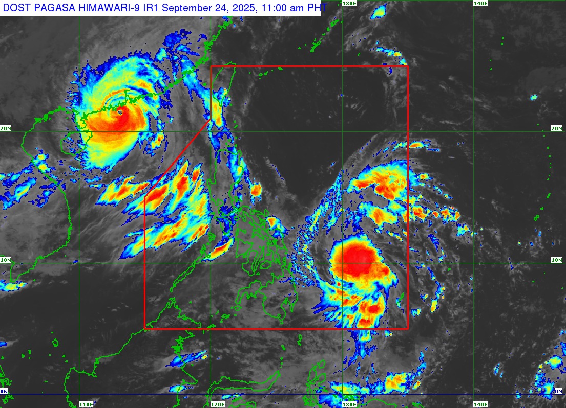
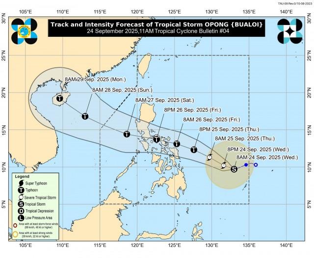
Opong was last spotted 815 km East of northeastern Mindanao, moving west-southwestward over the Philippine Sea at 15 km/h. It is packing maximum sustained winds of 85 km/h near the center, gustiness of up to 105 km/h, and central pressure of 996 hPa.
Meanwhile, Opong and Nando, which left the Philippine Area of Responsibility (PAR) on Tuesday, will continue to enhance the Southwest Monsoon.
Due to this, strong to gale-force gusts are expected in the following areas:
• Today (September 24): Ilocos Region, Cordillera Administrative Region, Batanes, Cagayan including Babuyan Islands, Isabela, Zambales, Bataan, Tarlac, Pampanga, Nueva Ecija, Bulacan, Metro Manila, Cavite, Batangas, Quezon, MIMAROPA, Western Visayas, Negros Island Region, Zamboanga del Norte, Misamis Occidental, Misamis Oriental, Camiguin, Agusan del Norte, Surigao del Norte, Dinagat Islands, Sarangani, Davao del Sur, and Davao Oriental.
• Tomorrow (September 25): Ilocos Region, Batanes, Cagayan including Babuyan Islands, Isabela, Zambales, Bataan, Zamboanga del Norte, and most of MIMAROPA, Visayas, Northern Mindanao, Caraga, and Davao Region
• Friday (September 26): Batanes, Cagayan including Babuyan Islands, Ilocos Norte, Ilocos Sur, Zamboanga del Norte, and most of MIMAROPA, Visayas, Northern Mindanao, Caraga, and Davao Region.
PAGASA also warned about a "potential risk of coastal flooding due to storm surge" in low-lying areas of Southern Luzon and Eastern Visayas. It added that a storm surge warning may be issued today or tomorrow.
Opong is expected to make landfall over the Bicol Region by Friday afternoon.
"OPONG will continue to intensify while over the Philippine Sea and may reach typhoon category before making landfall over Bicol Region. It will then weaken as it crosses the archipelago, although it will likely remain as a typhoon or severe tropical storm during the passage," PAGASA said.
"It must be emphasized that heavy rainfall, severe winds, and storm surge may still be experienced in localities outside the landfall point and the forecast confidence cone," it added.
Opong is expected to exit PAR by Saturday evening or Sunday morning. —VAL, GMA Integrated News
