

Signal No. 2 up over 6 areas as Opong gains strength
Severe Tropical Storm Opong continues to intensify, covering more areas with tropical cyclone wind signal while moving west northwestward over the Philippine Sea, PAGASA said on Thursday.
According to its 5 a.m. cyclone bulletin, Opong is forecast to bring heavy rainfall and severe winds over the affected areas.
The center of the eye of Opong was estimated at 440 kilometers East of Guiuan, Eastern Samar. It is moving west northwestward at 20 km/h with maximum sustained winds of 110 km/h near the center and gustiness of up to 135 km/h.
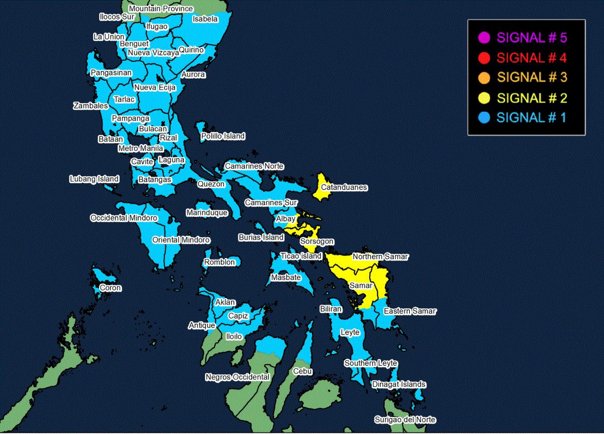
Signal No. 2 is hoisted over the following Luzon and Visayas areas:
Luzon
- Catanduanes
- the southern portion of Albay (Santo Domingo, Legazpi City, Camalig, Rapu-Rapu, Bacacay, Daraga, Jovellar, Manito)
- Sorsogon
Visayas
- Northern Samar
- the northern and central portions of Eastern Samar (Can-Avid, Maslog, San Policarpo, Taft, Dolores, Jipapad, Oras, Arteche, Sulat, San Julian)
- the northern and central portions of Samar (San Jorge, San Sebastian, Villareal, Zumarraga, Matuguinao, Pinabacdao, Almagro, Calbayog City, Talalora, Jiabong, Pagsanghan, City of Catbalogan, Gandara, Motiong, Santo Niño, Tagapul-An, San Jose de Buan, Santa Margarita, Tarangnan, Calbiga, Daram, Paranas, Hinabangan)
The following areas are under Signal No. 1:
Luzon
- the rest of Albay
- Masbate including Ticao Isl. and Burias Isl.
- Camarines Sur
- Camarines Norte
- Marinduque
- Romblon
- Oriental Mindoro
- Occidental Mindoro including Lubang Islands
- Quezon including Polillo Islands
- Rizal
- Laguna
- Batangas
- Cavite
- Aurora
- Metro Manila
- Bulacan
- Nueva Ecija
- Tarlac
- Pampanga
- Zambales
- Bataan
- the central and southern portions of Isabela (Alicia, San Mateo, Aurora, Ramon, Naguilian, Dinapigue, San Guillermo, Luna, City of Cauayan, Echague, Angadanan, Benito Soliven, City of Santiago, Reina Mercedes, San Agustin, San Manuel, Cabatuan, Gamu, San Isidro, Cordon, Jones, Burgos, San Mariano, Palanan)
- Quirino
- Nueva Vizcaya
- Ifugao
- the southwestern portion of Mountain Province (Bauko, Sabangan, Tadian)
- Benguet
- the southern portion of Ilocos Sur (Sugpon, Alilem)
- La Union
- Pangasinan
Visayas
- the rest of Eastern Samar and the rest of Samar
- Biliran
- Leyte
- Southern Leyte
- the northern portion of Cebu (Daanbantayan, Medellin, City of Bogo, Tabogon, San Remigio, Borbon, Sogod, Tabuelan, Catmon, Tuburan, Carmen, Danao City, Asturias, Compostela) including Camotes Isl. and Bantayan Isl.
- the northern portion of Negros Occidental (City of Escalante, Toboso, Calatrava, Sagay City, Cadiz City, Manapla, City of Victorias, Enrique B. Magalona, Silay City, City of Talisay)
- the northern portion of Iloilo (San Dionisio, Batad, Balasan, Carles, Sara, Concepcion, Ajuy, Lemery, Barotac Viejo, San Rafael, Banate, Anilao, San Enrique, City of Passi, Bingawan, Calinog, Lambunao, Dueñas, Dingle)
- Capiz
- Aklan
- the northern and central portions of Antique (Libertad, Pandan, Sebaste, Culasi, Tibiao, Barbaza, Bugasong, Laua-An) including Caluya Islands and Calamian Islands
Mindanao
- Siargao Island
- Bucas Grande Island
- Dinagat Island
Landfall on Friday
Opong is forecast to begin moving west northwestward while approaching Eastern Visayas – Southern Luzon area.
"On the forecast track, Opong may make landfall over Bicol Region by tomorrow, 26 September, afternoon or evening and cross Southern Luzon throughout Friday. Afterwards, it will continue moving generally west northwestward over the West Philippine Sea and exit the Philippine Area of Responsibility on Saturday, 27 September, afternoon or evening," PAGASA said.
It added that Opong will continue to intensify while over the Philippine Sea and may reach typhoon category before making landfall over Bicol Region.
The weather bureau said Opong is expected to weaken as it crosses the archipelago, although it will likely remain as a typhoon or severe tropical storm during the passage.
"Re-intensification is highly likely once Opong emerges over the West Philippine Sea," it said.
Daily weather forecast
As a result of Opong, Catanduanes, Sorsogon, Eastern Samar, Northern Samar, and Samar will experience stormy weather conditions on Thursday. PAGASA warns of possible floods or landslides due to moderate to heavy rains, and of minor to moderate threat to life and property due to strong winds.
The rest of Bicol Region, Quezon including Polillo Islands, Rizal, Laguna, Batangas, Marinduque, Oriental Mindoro, Romblon, Aklan, Capiz, Biliran, Leyte, Southern Leyte, Dinagat Islands, and Surigao del Norte will have rains with gusty winds also due to Opong.
The severe tropical storm will also bring cloudy skies with scattered rains and thunderstorms to Central Visayas, Isabela, Aurora, and the rest of Caraga.
Meanwhile, the Southwest Monsoon is forecast to bring occasional rains to Zambales, Bataan, and Occidental Mindoro.
Metro Manila, rest of Western Visayas, Negros Island Region, rest of Central Luzon, Zamboanga Peninsula, Northern Mindanao, Palawan, and Cavite will see cloudy skies with scattered rains and thunderstorms, also as a result of the Southwest Monsoon.
The rest of Luzon will experience partly cloudy to cloudy skies with isolated rainshowers or thunderstorms due to the localized thunderstorms.
The rest of Mindanao will have partly cloudy to cloudy skies with isolated rainshowers or thunderstorms because of the Southwest Monsoon.
Sunrise is at 5:45 a.m. and sunset is at 5:50 p.m. —LDF, GMA Integrated News
