

Opong draws nearer to Eastern Visayas; 3 areas under Signal No. 3
Signal No. 3 is hoisted in three areas in the country as Severe Tropical Storm Opong continues to move closer to Eastern Visayas, PAGASA said Thursday evening.
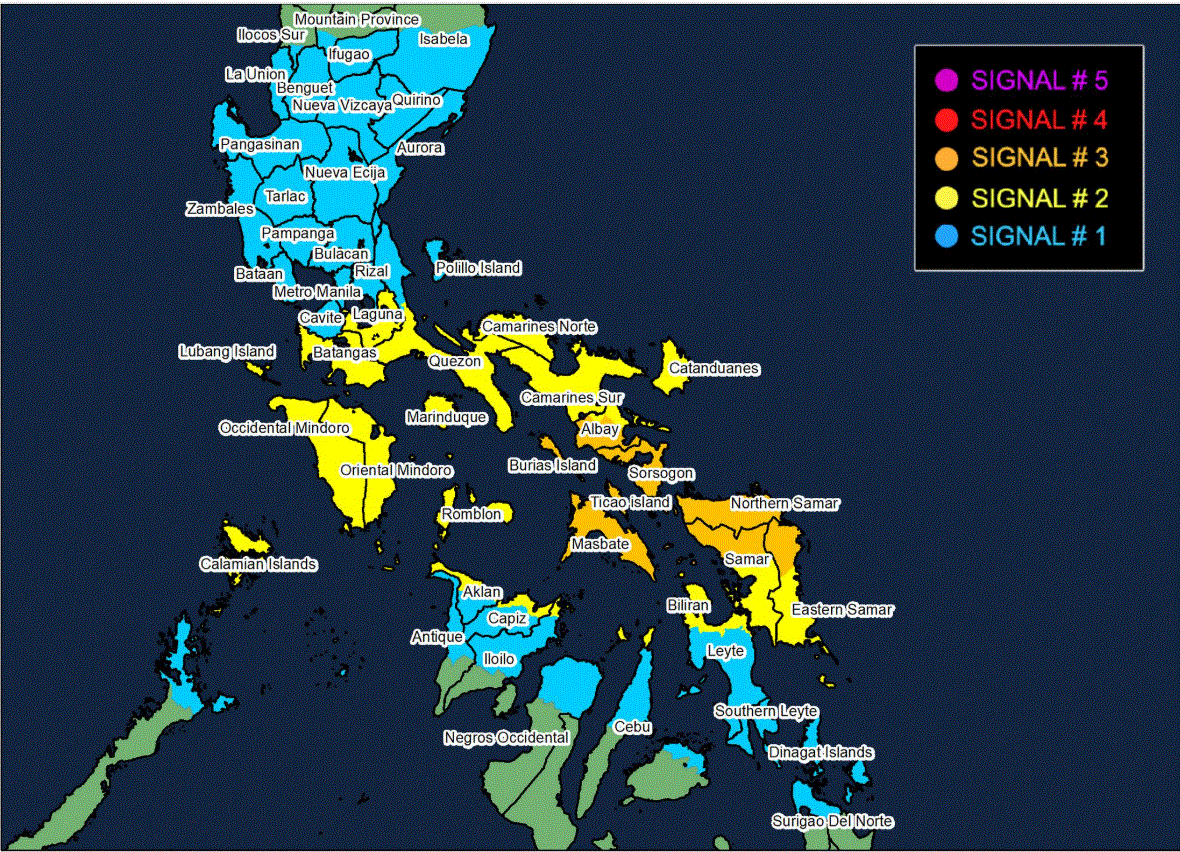
Based on its 8 p.m. cyclone bulletin, the state weather bureau said the following areas are under Signal No. 3:
- Sorsogon
- Southern portion of Albay (Manito, Legazpi City, Daraga, Camalig, Guinobatan, City of Ligao, Pio Duran, Jovellar, Libon, Oas)
- Masbate
Signal No. 2 is raised in the following areas:
- Laguna
- Batangas
- Southern portion of Quezon (Pitogo, San Andres, Buenavista, Lucena City, San Francisco, Calauag, Pagbilao, Tiaong, Lopez, Catanauan, Mulanay, Guinayangan, Unisan, General Luna, Plaridel, Quezon, San Antonio, Alabat, Candelaria, Lucban, Sampaloc, Padre Burgos, Sariaya, City of Tayabas, Macalelon, Mauban, Dolores, Perez, Agdangan, Gumaca, Atimonan, San Narciso, Tagkawayan)
- Camarines Norte
- Camarines Sur
- The rest of Albay
- Catanduanes
- Marinduque
- Occidental Mindoro
- Oriental Mindoro
- Romblon
- Calamian Islands
Signal No. 1 is hoisted in the following areas:
- The central and southern portions of Isabela (Alicia, San Mateo, Aurora, Ramon, Naguilian, Dinapigue, San Guillermo, Luna, City of Cauayan, Echague, Angadanan, Benito Soliven, City of Santiago, Reina Mercedes, San Agustin, San Manuel, Cabatuan, Gamu, San Isidro, Cordon, Jones, Burgos, San Mariano, Palanan)
- Quirino
- Nueva Vizcaya
- Ifugao
- Southwestern portion of Mountain Province (Bauko, Sabangan, Tadian)
- Benguet
- The southern portion of Ilocos Sur (Sugpon, Alilem)
- La Union
- Pangasinan
- Aurora
- Nueva Ecija
- Tarlac
- Zambales
- Bataan
- Pampanga
- Bulacan
- Metro Manila
- Rizal
- Cavite
- The rest of Quezon
- Cuyo Islands
- Northern mainland Palawan (El Nido, Taytay, Dumaran, Araceli)
Opong was located at 150 kilometers East of Borongan City, Eastern Samar, moving at maximum sustained winds of 110 km/h near the center and gustiness of up to 135 km/h. It was traveling west northwestward at 20 km/h.
PAGASA said Signal No. 4 may be the highest wind signal hoisted throughout Opong’s passage.
The storm is forecast to make landfall over Northern Samar or the northern portion of Eastern Samar on Friday early morning before heading towards the Bicol Region, where it is likely to make another landfall in the vicinity of Sorsogon Friday morning.
“Opong may reach typhoon category before making landfall. It will then weaken as it crosses the archipelago, although it will likely remain as a typhoon or severe tropical storm during the passage,” state meteorologists said.
“Re-intensification is highly likely once OPONG emerges over the West Philippine Sea,” it added.
The state weather bureau also warned that heavy rainfall, severe winds, and storm surge may still be experienced in localities outside the landfall point and the forecast confidence cone. “Furthermore, the track may still shift more to the north or to the south but within the limit of the forecast confidence cone,” PAGASA said.
Meanwhile, the Southwest Monsoon enhanced by Opong is expected to bring strong to gale-force gusts over the Ilocos Region, Cordillera Administrative Region, Cagayan Valley, Palawan, Visayas, Zamboanga del Norte, Misamis Occidental, Misamis Oriental, Camiguin, Caraga Region, and Davao Region.
PAGASA also said high risk of life-threatening storm surge with peak heights exceeding 3.0 m within 36 hours over the low-lying or exposed coastal localities of Zambales, Bataan, Metro Manila, CALABARZON, Occidental Mindoro including Lubang Island, Oriental Mindoro, Marinduque, Romblon, Palawan, Bicol Region, Northern Samar, Eastern Samar, Samar, Biliran, Leyte, Cebu, Aklan, Antique, Capiz, Dinagat Islands, and Siargao Island. —LDF, GMA Integrated News
