

Signal No. 3 raised over parts of Luzon; Paolo now a severe tropical storm
Tropical Cyclone Wind Signal No. 3 was hoisted in several parts of Luzon as Paolo developed into a severe tropical storm being monitored inside the Philippine Area of Responsibility (PAR), PAGASA said Thursday evening.
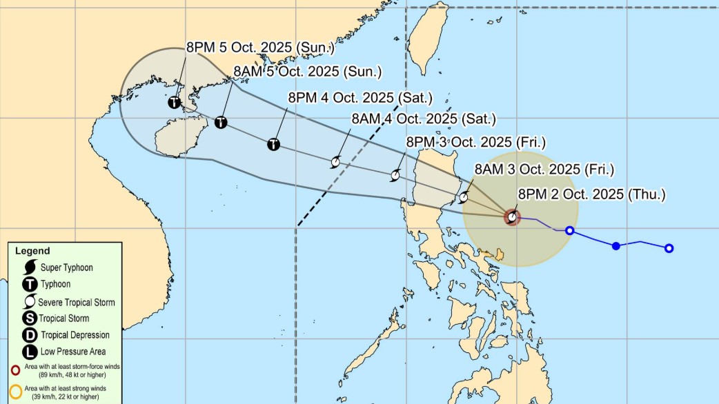
According to the 11 p.m. weather bulletin, Paolo was monitored at 320 kilometers east of Baler, Aurora. It has maximum sustained winds of 95 kilometers per hour, and gustiness of up to 115 kilometers per hour. The severe tropical storm is moving westward at 30 kilometers per hour.
The following areas have been placed under Signal No. 3:
- The extreme northern portion of Aurora (Dilasag, Casiguran)
- the central and southern portions of Isabela (Dinapigue, San Mariano, San Guillermo, Echague, Jones, San Agustin, Cordon, City of Santiago, Ramon, San Isidro, Alicia, Angadanan, City of Cauayan, Benito Soliven, Naguilian, Luna, Reina Mercedes, Cabatuan, San Mateo, Aurora, San Manuel, Burgos, Gamu, Roxas, Palanan)
- the northern portion of Quirino (Maddela, Cabarroguis, Aglipay, Saguday, Diffun)
- the northern portion of Nueva Vizcaya (Diadi, Bagabag, Villaverde, Ambaguio, Quezon, Solano, Bayombong)
- Mountain Province
- Ifugao
- the northern portion of Benguet (Mankayan, Buguias, Kabayan, Bakun)
Meanwhile, Signal No. 2 was raised in the areas below:
- The southern portion of mainland Cagayan (Peñablanca, Tuguegarao City, Enrile, Solana, Iguig, Tuao, Piat, Rizal)
- the rest of Isabela
- the rest of Quirino
- the rest of Nueva Vizcaya
- the northern and central portions of Aurora (Dinalungan, Dipaculao, Baler, Maria Aurora)
- the northeastern portion of Nueva Ecija (Carranglan, Pantabangan)
- the southern portion of Apayao (Conner)
- Kalinga
- Abra
- the rest of Benguet, the southern portion of Ilocos Norte (Nueva Era, Badoc, Pinili, City of Batac, Paoay, Currimao, Banna)
- Ilocos Sur
- La Union
Further, the following areas under Signal No. 1:
- The rest of mainland Cagayan including Babuyan Islands
- the rest of Aurora
- the northern portion of Quezon (General Nakar, Infanta) including Polillo Islands
- Camarines Norte
- the northern portion of Camarines Sur (Siruma, Tinambac, Lagonoy, Garchitorena, Caramoan, Goa, San Jose, Presentacion)
- Catanduanes
- the rest of Apayao
- the rest of Ilocos Norte
- Pangasinan
- the rest of Nueva Ecija
- the northern portion of Bulacan (Doña Remedios Trinidad, San Miguel, San Ildefonso, Norzagaray, San Rafael)
- Tarlac
- the northeastern portion of Pampanga (Magalang, Arayat, Candaba, Mabalacat City)
- the northern portion of Zambales (Palauig, Masinloc, Candelaria, Santa Cruz)
PAGASA said Paolo may make landfall over Isabela or northern Aurora on Friday morning, October 3. It will continue to intensify while over the Philippine Sea.
While further intensification into a typhoon prior to landfall is not ruled out, PAGASA said that intensification is highly likely once Paolo emerges over the West Philippines Sea
The state weather bureau said that Paolo may exit the PAR on Saturday morning, October 4.
The state weather bureau also warned that there is a moderate to high risk of life-threatening storm surge with peak heights reaching 1.0 to 3.0 m within 36 hours over the low-lying or exposed coastal localities of Ilocos Norte, Ilocos Sur, Cagayan, Isabela, Aurora, and Quezon. —Vince Angelo Ferreras/RF, GMA Integrated News
