

Paolo nears landfall over Aurora-Isabela; Signal No. 3 raised in 10 areas
Tropical Cyclone Wind Signal (TCWS) No. 3 was raised in over 10 areas of Luzon as Severe Tropical Storm Paolo is close to making landfall over the Aurora-Isabela area, state weather bureau PAGASA said Friday
In its 8 a.m. bulletin, PAGASA raised the following Tropical Cyclone Wind Signals:
Signal No. 3
- the northern portion of Aurora (Dilasag, Casiguran, Dinalungan)
- the central and southern portions of Isabela (Dinapigue, San Mariano, San Guillermo, Echague, Jones, San Agustin, Cordon, City of Santiago, Ramon, San Isidro, Alicia, Angadanan, City of Cauayan, Benito Soliven, Naguilian, Luna, Reina Mercedes, Cabatuan, San Mateo, Aurora, San Manuel, Burgos, Gamu, Roxas, Palanan)
- the northern portion of Quirino (Maddela, Cabarroguis, Aglipay, Saguday, Diffun)
- the northern portion of Nueva Vizcaya (Diadi, Bagabag, Villaverde, Ambaguio, Quezon, Solano, Bayombong)
- Mountain Province
- Ifugao
- the southeastern portion of Abra (Tubo)
- the northern portion of Benguet (Mankayan, Buguias, Kabayan, Bakun, Kibungan, Atok, Kapangan)
- the central and southern portions of Ilocos Sur (Sugpon, Alilem, Cervantes, Suyo, Tagudin, Santa Cruz, Sigay, Quirino, Gregorio del Pilar, Salcedo, Santa Lucia, City of Candon, San Emilio, Galimuyod, Lidlidda, Banayoyo, Santiago, San Esteban, Burgos)
- the northern portion of La Union (Sudipen, Santol, Balaoan, Luna, Bangar, San Gabriel, Bacnotan, San Juan)
Signal No. 2
- the central and southern portions of mainland Cagayan (Peñablanca, Tuguegarao City, Enrile, Solana, Iguig, Tuao, Piat, Rizal, Santo Niño, Alcala, Amulung)
- the rest of Isabela
- the rest of Quirino
- the rest of Nueva Vizcaya
- the central portion of Aurora (Dipaculao, Baler, Maria Aurora, San Luis)
- the northern portion of Nueva Ecija (Carranglan, Bongabon, San Jose City, Pantabangan, Rizal, Lupao)
- the central and southern portions of Apayao (Conner, Kabugao)
- Kalinga
- the rest of Abra
- the rest of Benguet
- the central and southern portions of Ilocos Norte (Nueva Era, Badoc, Pinili, City of Batac, Paoay, Currimao, Banna, Laoag City, San Nicolas, Sarrat, Dingras, Solsona, Marcos, Bacarra, Piddig),
- the rest of Ilocos Sur
- the rest of La Union
- the northern portion of Pangasinan (San Fabian, Sison, Pozorrubio, Umingan, San Jacinto, Laoac, Binalonan, San Nicolas, Natividad, Tayug, San Manuel, Asingan, Santa Maria, San Quintin, Dagupan City, Mangaldan, Manaoag, Bolinao, Anda, Bani, City of Alaminos, Sual, Labrador, Lingayen, Binmaley, Calasiao, Mapandan, Santa Barbara, City of Urdaneta)
Signal No. 1
- the rest of mainland Cagayan including Babuyan Islands
- the rest of Aurora
- the northern portion of Quezon (General Nakar, Infanta) including Polillo Islands
- Camarines Norte
- the northern portion of Camarines Sur (Siruma, Tinambac, Lagonoy, Garchitorena, Caramoan, Goa, San Jose, Presentacion)
- Catanduanes
- the rest of Apayao
- the rest of Ilocos Norte
- the rest of Pangasinan
- the rest of Nueva Ecija
- the northern portion of Bulacan (Doña Remedios Trinidad, San Miguel, San Ildefonso, Norzagaray, San Rafael, Angat)
- Tarlac
- The northeastern portion of Pampanga (Magalang, Arayat, Candaba, Mabalacat City)
- The northern portion of Zambales (Palauig, Masinloc, Candelaria, Santa Cruz)
LIVE UPDATES: Paolo (Oct. 3, 2025)
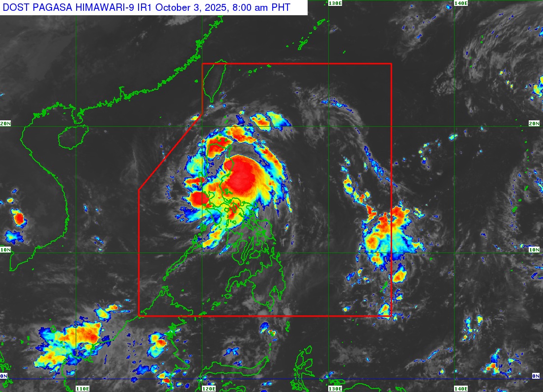
Paolo was last spotted over the coastal waters of Dilasag, Aurora with maximum sustained winds of 110 kilometers per hour and gustiness of up to 150 kph.
The severe tropical storm was moving west northwestward at 25 kph.
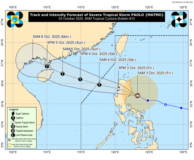
“On the forecast track, PAOLO may make landfall in northern Aurora or southern Isabela this morning. Further southward shift of track is possible depending on the strength of the high pressure area located north of PAOLO,” PAGASA said.
According to PAGASA, Paolo may intensify as a typhoon.
“PAOLO may maintain its strength or slightly weaken while traversing the rugged terrain. Further intensification into a typhoon prior to landfall is not ruled out however, based on the intensity forecast, intensification into typhoon is highly likely once PAOLO emerges over the West Philippine Sea,” it said.
Some classes and work in government offices have been suspended in some parts of the country due to the threat posed by Tropical Storm Paolo. —VAL, GMA Integrated News
