

Paolo slightly weakens; Signal No. 4 up in 9 areas
State weather bureau PAGASA said nine areas are under Signal No. 4 as Typhoon Paolo slightly weakened while traversing the mountainous area of Northern Luzon Friday afternoon.
In its 2 p.m. bulletin, PAGASA raised the following Tropical Cyclone Wind Signals:
Signal No. 4- the southwestern portion of Isabela (Dinapigue, San Mariano, Palanan, Roxas, Burgos, Gamu, Naguilian, Benito Soliven, San Manuel, Cabatuan, Aurora, Luna, Reina Mercedes, City of Cauayan, San Mateo, Alicia, Ramon, City of Santiago, Cordon, San Isidro, Echague, Angadanan, San Guillermo, Jones, San Agustin)
- the northwestern portion of Quirino (Diffun, Aglipay, Saguday, Cabarroguis)
- the northern portion of Nueva Vizcaya (Solano, Villaverde, Bagabag, Diadi, Quezon, Ambaguio, Bayombong)
- Mountain Province
- Ifugao
- the southern portion of Abra (Tubo)
- the northern portion of Benguet (Bakun, Mankayan, Buguias, Kibungan, Kapangan, Atok, Kabayan)
- the southern portion of Ilocos Sur (Cervantes, Quirino, Gregorio del Pilar, Sigay, San Emilio, Salcedo, Burgos, Lidlidda, Banayoyo, San Esteban, Santiago, Galimuyod, City of Candon, Santa Lucia, Santa Cruz, Suyo, Alilem, Tagudin, Sugpon)
- and the northern portion of La Union (Luna, Bangar, Balaoan, Sudipen, Santol, San Gabriel, Bacnotan, San Juan)
Signal No. 3
- the northern and central portions of Aurora (Dinalungan, Dipaculao, Casiguran, Dilasag)
- the rest of Isabela
- the rest of Quirino
- the central portion of Nueva Vizcaya (Kasibu, Bambang, Kayapa, Aritao, Dupax del Norte, Dupax del Sur, Santa Fe)
- Kalinga
- the central portion of Abra (Boliney, Daguioman, Sallapadan, Bucloc, Licuan-Baay, Malibcong, Lacub, La Paz, San Juan, Lagangilang, Danglas, Lagayan, Tayum, Bangued, Langiden, Pidigan, San Quintin, Pilar, Luba, Manabo, Villaviciosa, San Isidro, Peñarrubia, Bucay, Dolores)
- the rest of Benguet,
- the rest of Ilocos Sur
- the rest of La Union
Signal No. 2
- the central and southern portions of Cagayan (Peñablanca, Tuguegarao City, Solana, Iguig, Tuao, Piat, Rizal, Santo Niño, Alcala, Amulung, Enrile, Baggao, Lasam, Gattaran, Lal-Lo, Allacapan)
- the rest of Nueva Vizcaya
- Apayao
- the rest of Abra
- the central and southern portions of Ilocos Norte (Nueva Era, Badoc, Pinili, City of Batac, Paoay, Currimao, Banna, Laoag City, San Nicolas, Sarrat, Dingras, Solsona, Marcos, Bacarra, Piddig, Pasuquin, Vintar, Carasi)
- Pangasinan
- the central portion of Aurora (Baler, Maria Aurora, San Luis)
- the northern portion of Nueva Ecija (Carranglan, Bongabon, San Jose City, Pantabangan, Rizal, Lupao, Science City of Muñoz, Llanera, Nampicuan, Cuyapo, Guimba, Talugtug, Quezon, Santo Domingo, Talavera, General Mamerto Natividad)
- the northern portion of Tarlac ( Moncada, San Clemente, Camiling, Paniqui, Ramos, Anao, San Manuel, Gerona, Victoria, Pura)
- the northern portion of Zambales ( Santa Cruz, Candelaria)
Signal No. 1
- Batanes
- the rest of mainland Cagayan including Babuyan Islands
- the rest of Ilocos Norte
- the rest of Aurora
- the rest of Nueva Ecija
- the rest of Tarlac
- Bulacan
- Pampanga
- the rest of Zambales
- the northern portion of Quezon (General Nakar, Infanta) including Polillo Islands
- Camarines Norte
LIVE UPDATES: Paolo (Oct. 3, 2025)
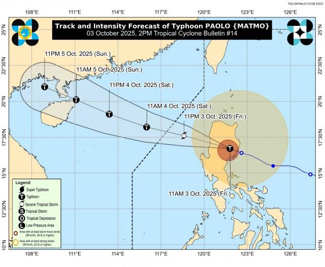
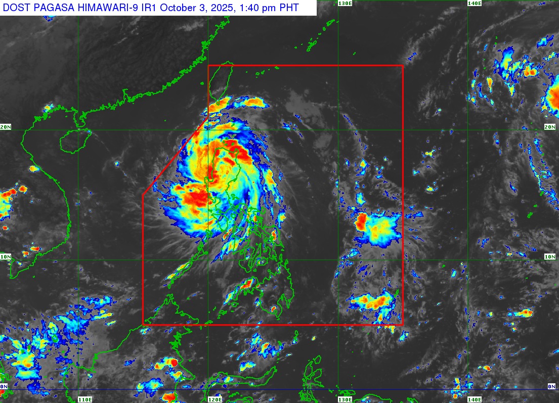
Paolo was last located in the vicinity of Mayoyao, Ifugao, packing maximum sustained winds of 120 kilometers per hour near the center and gustiness of up to 200 kph.
The typhoon was moving west northwestward at 30 kph.
“On the forecast track, PAOLO will cross the landmass of Northern Luzon today, and emerge over the West Philippine Sea this afternoon or evening. It will exit the Philippine Area of Responsibility tomorrow (04 October) morning,” PAGASA said.
“PAOLO may slightly weaken while traversing the rugged terrain of Northern Luzon, although maintaining typhoon category is not ruled out. Based on the intensity forecast, re-intensification is highly likely once PAOLO emerges over the West Philippine Sea,” it added. —VAL, GMA Integrated News
