

Ramil slightly intensifies, Signal no. 1 up in 11 areas
Signal number 1 has been raised in 11 different areas as Tropical Depression Ramil slightly intensifies as it moves over the Philippine Sea.
Signal No. 1
- The eastern and southern portions of Quezon (Tagkawayan, Perez, Alabat, Quezon, Atimonan, Padre Burgos, Unisan, Gumaca, Plaridel, Agdangan, Pagbilao, Mauban, Calauag, Guinayangan, Lopez, Pitogo, Macalelon, General Luna, Catanauan, San Narciso, Buenavista, San Francisco, San Andres, Mulanay) including Pollilo Islands
- Camarines Norte
- Camarines Sur
- Catanduanes
- Albay
- Sorsogon
- Burias Island
- Ticao Island
- Northern Samar
- The northern portion of Eastern Samar (San Policarpo, Arteche, Oras, Dolores, Maslog, Jipapad, Taft, Can-Avid),
- The northern portion of Samar (Matuguinao, San Jose de Buan, Calbayog City, Gandara, Santa Margarita, Pagsanghan, San Jorge)
According to PAGASA’s 11 a.m. areas under Signal No. 1 will feel winds of 39 to 61 kph in at least 36 hours or intermittent rains within 36 hours.
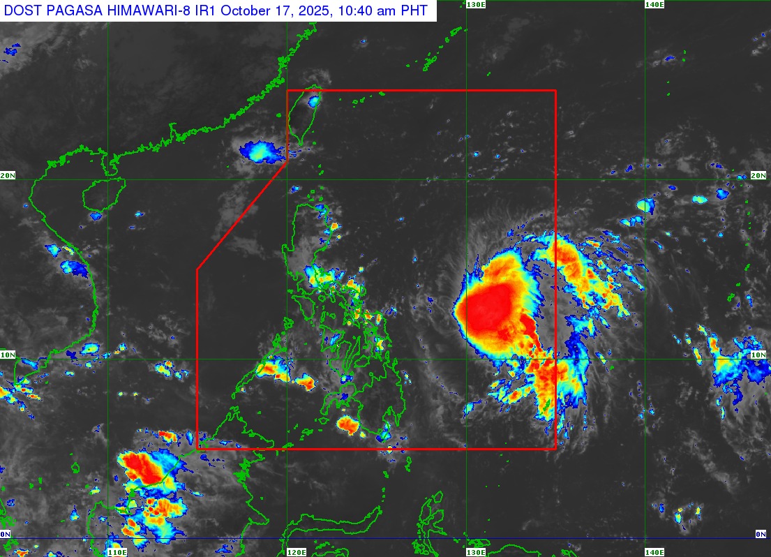
As of 11 a.m., Tropical Depression Ramil was located 760 kilometers east of Virac, Catanduanes.
It had maximum sustained winds of 55 kph near the center and gustiness of up to 70 kph.
“The highest Wind Signal that will likely be hoisted throughout its passage is Wind Signal No. 2. However, the possibility of reaching severe tropical storm category before landfall is not ruled out, the worst case scenario is Wind Signal No. 3,” read the advisory.
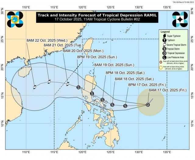
Ramil is forecast to make landfall over Catanduanes on Saturday afternoon and again in Aurora or Quezon by Sunday morning before exiting the Philippine Area of Responsibility (PAR) by Monday morning or afternoon.
“A southward shift of the track could lead to a different landfall area and more inclusion of localities under Wind Signal,” the advisory added.
It may also intensify into a tropical storm within 12 hours, and further intensification into a severe tropical storm before landfall is possible.
Meanwhile, the combined effects of Ramil and the easterlies may cause strong gale-force gusts in areas without wind signals.
It may also cause minimal to moderate risk of storm surge with peak heights reaching 1.0 to 2.0 m within 48 hours over mainland Cagayan, Isabela, Aurora, Quezon including Polillo Islands, Camarines Norte, Camarines Sur, Catanduanes, Albay, Sorsogon, and Northern Samar..
Rough sea conditions may be observed over the northern seaboard of Eastern Visayas and the seaboards of Southern Luzon, which may prompt gale warnings. —VAL, GMA Integrated News
