

Signal No. 4 up in 8 areas as Tino slightly intensifies
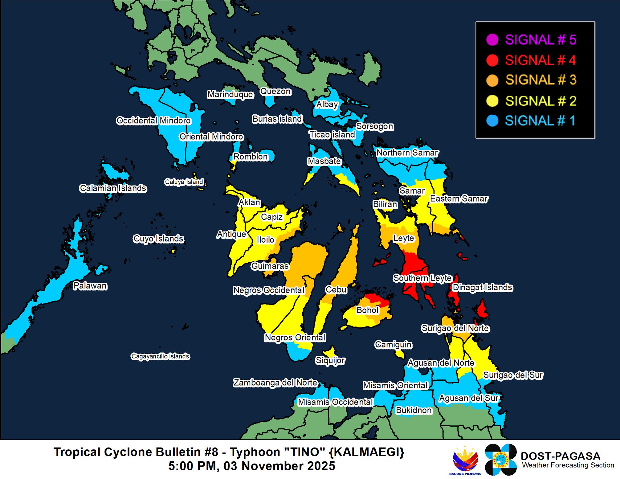
Signal No. 4 is hoisted in eight areas as Typhoon Tino slightly intensified while drawing near Eastern Visayas in the Caraga area, PAGASA said late Monday afternoon.
Based on the state weather bureau's 5 p.m. weather bulletin, the following areas are under Signal No. 4
Visayas- Extreme southeastern portion of Eastern Samar (Guiuan)
- Southern portion of Leyte (Mahaplag, Abuyog, City of Baybay, Inopacan, Hilongos, Hindang, Bato, Matalom, Javier)
- Southern Leyte
- Camotes Islands
- Northeastern portion of Bohol (Pres. Carlos P. Garcia, Getafe, Trinidad, Ubay, Bien Unido, Talibon)
Mindanao
- Dinagat Islands
- Siargao
- Bucas Grande Islands
Signal No. 3 is hoisted in the following areas:
Visayas
- Southern portion of Eastern Samar (Mercedes, Lawaan, Balangiga, Giporlos, Quinapondan, Salcedo)
- Southern portion of Samar (Marabut)
- Central portion of Leyte (Tanauan, Palo, Tabontabon, Isabel, Merida, Palompon, Ormoc City, Dagami, Pastrana, Burauen, Albuera, Macarthur, La Paz, Mayorga, Dulag, Julita, Tolosa, Matag-Ob, Villaba, Kananga, Jaro)
- Northern and central portions of Cebu (Borbon, Sogod, Catmon, Carmen, Danao City, Compostela, Liloan, Lapu-Lapu City, Cordova, Consolacion, Mandaue City, Cebu City, Asturias, Balamban, Tuburan, Tabuelan, Tabogon, City of Talisay, City of Bogo, San Remigio, Medellin, Daanbantayan, Sibonga, City of Carcar, San Fernando, City of Naga, Minglanilla, Toledo City, Aloguinsan, Pinamungahan, Barili, Dumanjug) including Bantayan Islands
- Central and eastern portions of Bohol (San Miguel, Mabini, Buenavista, Inabanga, Danao, Dagohoy, Guindulman, Pilar, Alicia, Candijay, Anda, Jagna, Duero, Sierra Bullones, Carmen, Sagbayan, Clarin, Tubigon)
- Northern portion of Negros Oriental (Vallehermoso, Canlaon City, City of Guihulngan)
- Northern portion of Negros Occidental (Hinigaran, Moises Padilla, Isabela, La Castellana, Pontevedra, San Enrique, La Carlota City, Cadiz City, Bago City, Enrique B. Magalona, Toboso, Valladolid, Salvador Benedicto, Sagay City, Bacolod City, Murcia, City of Escalante, Calatrava, San Carlos City, Silay City, Pulupandan, City of Victorias, City of Talisay, Manapla)
- Guimaras
- Eastern portion of Iloilo (Concepcion, Barotac Nuevo, Ajuy, Iloilo City, Anilao, Barotac Viejo, Leganes, Zarraga, Dumangas, Banate)
Mindanao
- The rest of Surigao del Norte
Signal No. 2 is up in the following areas:
Luzon
- Southern portion of Masbate (Esperanza, Pio V. Corpuz, Placer, Balud, Cawayan)
- Southern portion of Romblon (San Jose, Santa Fe, Alcantara, Looc)
- Cuyo Islands
Visayas
- Central portion of Eastern Samar (Can-Avid, City of Borongan, Taft, Llorente, Maydolong, Balangkayan, Sulat, San Julian, General Macarthur, Hernani)
- Central portion of Samar (San Sebastian, Santa Rita, Villareal, Zumarraga, Pinabacdao, Talalora, Jiabong, City of Catbalogan, Motiong, Calbiga, Daram, Paranas, Basey, Hinabangan, Santo Niño, Almagro, Tarangnan)
- The rest of Leyte
- Biliran
- The rest of Bohol
- The rest of Cebu
- Central portion of Negros Oriental (Tayasan, Manjuyod, City of Tanjay, Bais City, Mabinay, Bindoy, Ayungon, Jimalalud, La Libertad, Sibulan, San Jose, Amlan, Pamplona, City of Bayawan, Basay, Valencia, Dumaguete City, Bacong)
- The rest of Negros Occidental
- Siquijor
- Capiz
- The rest of Iloilo
- Aklan
- Antique
Mindanao
- Northern portion of Surigao del Sur (Carrascal, Cantilan, Madrid, Carmen, Lanuza, Cortes, Tago, San Miguel, Marihatag, Cagwait, Bayabas, City of Tandag)
- Northern portion of Agusan del Sur (Sibagat)
- Northern portion of Agusan del Norte (Kitcharao, Jabonga, Santiago, Tubay, City of Cabadbaran, Remedios T. Romualdez, Magallanes)
- Camiguin
The following areas are under Signal No. 1:
Luzon
- Albay
- Sorsogon
- The rest of Masbate including Ticao and Burias Islands
- The southern portion of Quezon (San Francisco, San Andres)
- The southern portion of Marinduque (Torrijos, Buenavista, Gasan, Boac)
- The rest of Romblon
- Oriental Mindoro
- Occidental Mindoro
- Northern and central portions of Palawan (El Nido, Taytay, Dumaran, Araceli, San Vicente, Roxas, Puerto Princesa City, Aborlan) including Calamian Islands and Cagayancillo Islands
“The wind signals warn the public of the general wind threat over an area due to the tropical cyclone. Local winds may be slightly stronger/enhanced in coastal and upland/mountainous areas exposed to winds,” PAGASA said.
Tino was located 170 km east southeast of Guiuan, Eastern Samar, and is carrying maximum sustained winds of 130 km/h near the center and gusts of up to 160 km/h, and is moving westward at 20 km/h.
Meanwhile, the surge of the Northeast Monsoon (Amihan) and the shear line coinciding with the passage of Tino will bring strong to gale-force gusts over Cagayan Valley, Cordillera Administrative Region, Ilocos Norte, Ilocos Sur, Central Luzon, Metro Manila, CALABARZON, MIMAROPA, and Bicol Region, which not under any Wind Signal, on Tuesday.
A high risk of life-threatening and damaging storm surge with peak heights exceeding 3.0 m is expected within the next 48 hours over the low-lying or exposed coastal communities of Masbate, Romblon, Oriental Mindoro, Occidental Mindoro, Palawan, Visayas, Dinagat Islands, Surigao del Norte, Surigao del Sur, Agusan del Norte, Misamis Oriental, and Camiguin.
Tino is expected to make landfall or pass very close to Homonhon Island or the Dinagat Islands tonight or early Tuesday morning.
Then, it is forecasted to make landfall over Leyte or Southern Leyte by early Tuesday morning, before crossing the Visayas and northern Palawan throughout Tuesday and early Wednesday morning.
“Heavy rainfall, severe winds, and storm surge may still be experienced in localities outside the landfall point and the forecast confidence cone,” PAGASA said.
It added that the storm will likely emerge over the West Philippine Sea by Wednesday morning or afternoon and is expected to exit the Philippine Area of Responsibility by Thursday.
“Tino is forecast to make its initial landfall at or near peak intensity. Rapid intensification before landfall remains likely,” PAGASA said.
“While the interaction of the typhoon with the terrain will trigger a slight weakening, Tino is expected to remain at typhoon category throughout its passage over the country,” it added. —RF, GMA Integrated News
