

Signal No. 2 in Kalayaan Islands as stronger Tino moves over West Philippine Sea
Signal No. 2 is hoisted in the Kalayaan Islands as Typhoon Tino further intensifies and moves over the West Philippine Sea.
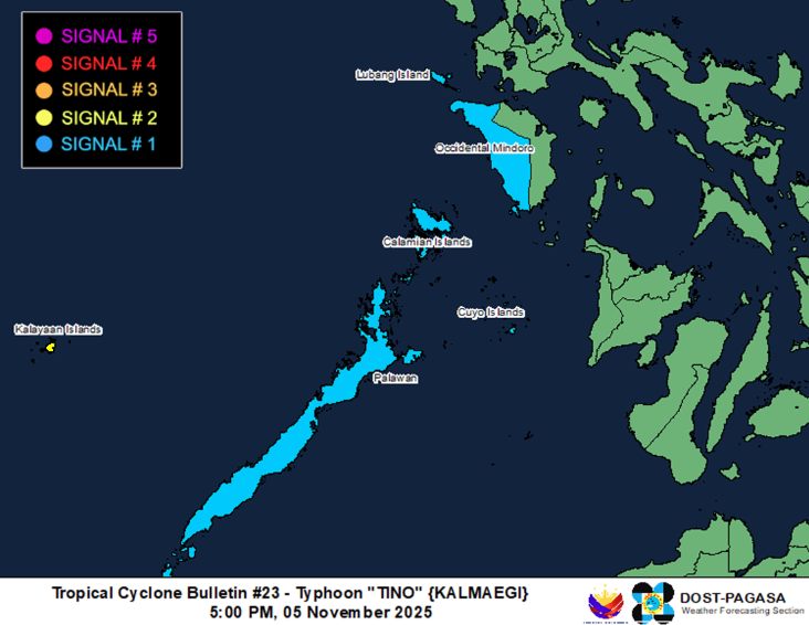
Tino was last located at 330 km east northeast of Pag-asa Island, Kalayaan, Palawan, carrying maximum sustained winds of 140 km/h near the center and gusts of up to 170 km/h, and is moving west northwestward at 30 km/h.
Based on PAGASA’s 5 p.m. cyclone bulletin, Occidental Mindoro, including Lubang Islands, and the rest of Palawan, including Calamian and Cuyo Islands, are under Signal No. 1.
PAGASA said on Wednesday, the weakening surge of the Northeast Monsoon (Amihan) and the outer rainbands of Tino will bring strong wind gusts over Batanes, Babuyan Islands, Ilocos Norte, Zambales, Bataan, Batangas, Oriental Mindoro, Marinduque, Romblon, and Antique, which are not under any wind signal.
“Heavy rainfall, severe winds, and storm surge may still be experienced in localities outside the landfall point and the forecast confidence cone,” state meteorologists said.
PAGASA warned that within the next 24 hours, a moderate risk of storm surge with peak heights reaching 1.0 to 2.0 m is expected over the low-lying or exposed coastal communities of Palawan.
Meanwhile, a gale warning is in effect over the seaboards of the Kalayaan Islands.
The state weather bureau said the typhoon will continue moving west-northwestward over the West Philippine Sea and exit the Philippine Area of Responsibility on Wednesday night or Thursday morning.
“Tino is forecast to re-intensify in the next 12 hours and may reach its peak intensity while over the West Philippine Sea,” PAGASA said. –NB, GMA Integrated News
