

Storm outside PAR keeps strength, moves west northwestward
The tropical depression outside the Philippine Area of Responsibility (PAR) maintained its strength while moving west northwestward, PAGASA said late Wednesday evening.
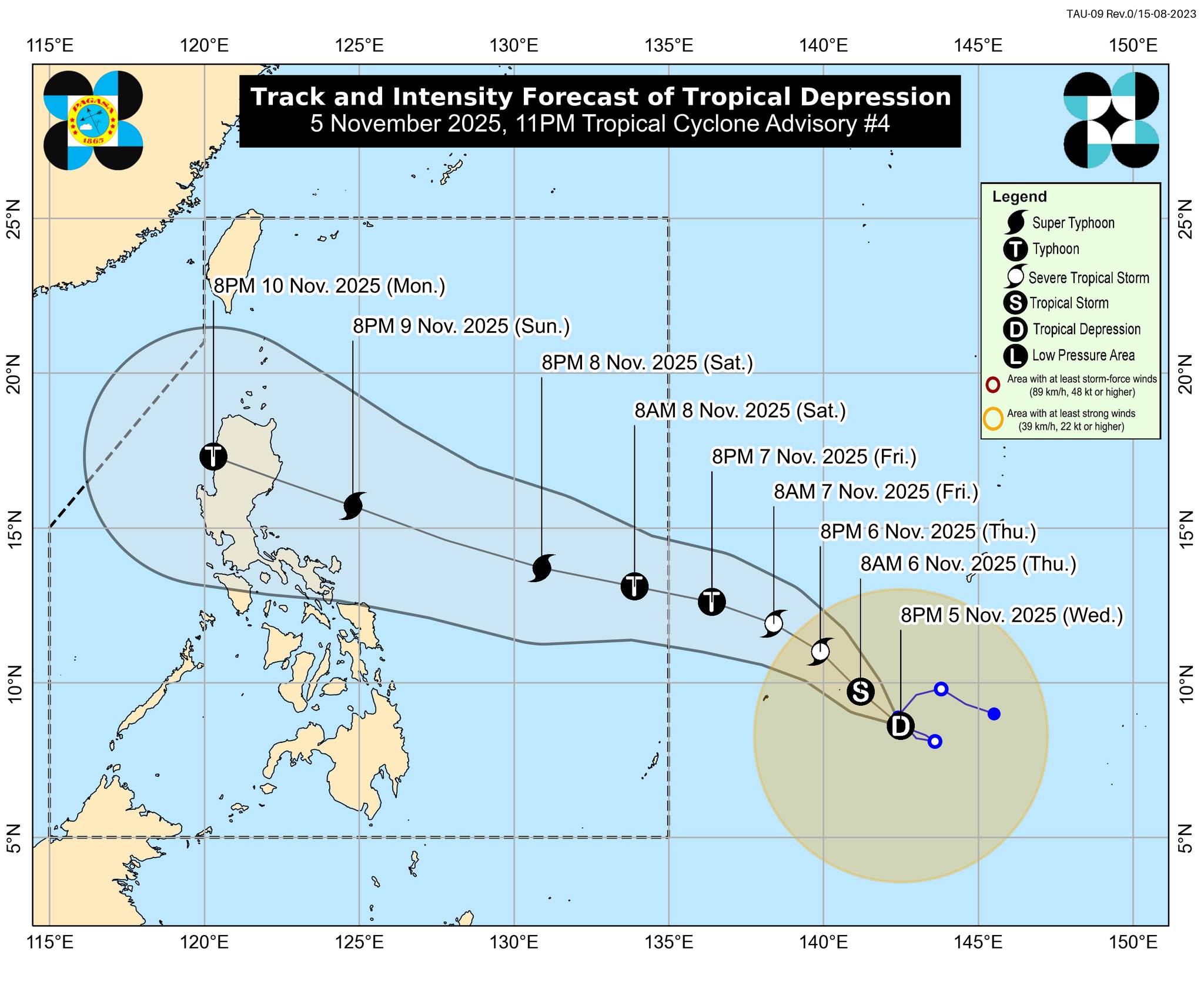
Based on PAGASA’s 11 p.m. tropical cyclone advisory, the storm was last monitored 1,770 km east of Northeastern Mindanao, carrying maximum sustained winds of 55 km/h near the center and gusts of up to 70 km/h. It was moving west northwestward at 15 km/h.
The tropical cyclone is expected to enter PAR late Friday evening or Saturday morning and will be named Uwan.
“Although the uncertainty in track and intensity forecast is typically high for day-4 and day-5 forecasts, there is an increasing chance of landfall on Monday over northern or Central Luzon,” PAGASA said.
“In terms of intensity, this TC is forecast to rapidly intensify and may reach typhoon category on Friday and super typhoon category on Saturday. It may also make landfall at or near its peak lifetime intensity,” it added.
State meteorologists also said wind signals may be hoisted over the eastern portion of Luzon and portions of Samar provinces as early as Friday evening or Saturday morning.
“The highest possible wind signal for the current forecast scenario is Wind Signal No. 5. Deterioration of weather conditions may begin on Sunday,” PAGASA said.
"Potentially life-threatening stormy conditions are expected over Northern Luzon and portions of Central Luzon on Monday (November 10) and Tuesday (November 11)," it added.
Meanwhile, a storm surge warning may be issued as early as Saturday, as high storm surge risk and related coastal flooding, especially in Northern Luzon and the east coast of Central Luzon, are expected.
PAGASA also warned that moderate to rough seas may be observed over the northern and eastern seaboards of Luzon and the eastern seaboards of Visayas and Mindanao on late Friday or Saturday.
The western and southern seaboards of Luzon will have moderate to rough sea conditions by mid-Saturday or Sunday, it added.
“Hazardous sea conditions (reaching very rough, high, very high, or phenomenal seas) may affect most of Luzon and the eastern seaboards of Southern Luzon and Visayas from Sunday onwards,” PAGASA said.
“A gale warning for very rough seas in coastal waters will likely be issued on Saturday,” it added. —Mariel Celine Serquiña/VBL, GMA Integrated News
