

Typhoon Uwan gains strength; 8 areas in Luzon, Visayas under Signal No. 2
Typhoon Uwan (international name: Fung-Wong) rapidly intensified over the last 24 hours as it marches across the Philippine Sea east of Eastern Visayas, prompting weather bureau PAGASA to declare Saturday eight areas in Luzon and Visayas under Tropical Weather Cyclone Signal (TWCS) No. 2.
In its 11 a.m. bulletin, PAGASA said Signal No. 2 was raised over the following areas:
Luzon
- Catanduanes
- Eastern portion of Camarines Sur (Siruma, Tinambac, Goa, Lagonoy, Buhi, Caramoan, Tigaon, Garchitorena, Calabanga, Sagñay, San Jose, Presentacion, Baao, Ocampo, Milaor, Nabua, Bato, Camaligan, Pili, Iriga City, Magarao, Minalabac, Balatan, Naga City, Bombon, Bula, Canaman)
- Albay
- Sorsogon
- Ticao Islands
Visayas
- Northern Samar
- Northern portion of Samar (Matuguinao, San Jose de Buan, Calbayog City)
- Northern portion of Eastern Samar (Maslog, San Policarpo, Dolores, Jipapad, Oras, Arteche)
Under Signal No. 2, winds of greater than 62 kph and up to 88 kph may be expected in at least 24 hours, according to PAGASA.
Further, minor to moderate impacts from gale-force winds are possible within any of the areas under Signal No. 2.
Meanwhile, Signal No. 1 was raised over the following areas:
Luzon
- Batanes
- Cagayan
- Isabela
- Quirino
- Nueva Vizcaya
- Apayao
- Abra
- Kalinga
- Mountain Province
- Ifugao
- Benguet
- Ilocos Norte
- Ilocos Sur
- La Union
- Pangasinan
- Aurora
- Nueva Ecija
- Bulacan
- Tarlac
- Pampanga
- Zambales
- Bataan
- Metro Manila
- Cavite
- Laguna
- Batangas
- Rizal
- Quezon
- Camarines Norte
- the rest of Camarines Sur
- the rest of Masbate including Burias Island
- Marinduque
- Romblon
- Oriental Mindoro
- Occidental Mindoro including Lubang Islands
- Calamian Islands
- Cuyo Islands
Visayas
- the rest of Samar
- the rest of Eastern Samar
- Biliran
- Leyte
- Southern Leyte
- Northeastern portion of Bohol (Getafe, Talibon, Buenavista, Trinidad, San Miguel, Ubay, Alicia, Mabini, Bien Unido, Pres. Carlos P. Garcia)
- the northern and central portions of Cebu (Medellin, Daanbantayan, City of Bogo, Tabogon, San Remigio, Tabuelan, Borbon, Sogod, Tuburan, Catmon, Carmen, Danao City, Compostela, Liloan, Consolacion, Lapu-Lapu City, Mandaue City, Cordova, Asturias, Cebu City, Balamban, City of Talisay, Toledo City, Minglanilla) including Bantayan and Camotes Islands
- Northern portion of Negros Occidental (City of Escalante, Toboso, Sagay City, Cadiz City, Calatrava, Manapla, City of Victorias, Enrique B. Magalona, Silay City, City of Talisay, San Carlos City, Salvador Benedicto, Murcia, Bacolod City)
- the northern and central portions of Iloilo (Carles, Estancia, Balasan, San Dionisio, Concepcion, Batad, Sara, Ajuy, Barotac Viejo, San Rafael, Lemery, Lambunao, Calinog, Bingawan, City of Passi, San Enrique, Anilao, Banate, Dingle, Dueñas, Janiuay, Badiangan, Mina, Pototan, Barotac Nuevo, Maasin, Cabatuan, New Lucena, Santa Barbara, Zarraga, Dumangas, Leon, Alimodian)
- Capiz
- Aklan
- Northern and central portions of Antique (Pandan, Libertad, Sebaste, Culasi, Valderrama, Tibiao, Barbaza, Laua-An, Bugasong, Patnongon, San Remigio) including Caluya Islands
Mindanao
- Dinagat Islands and Surigao del Norte
Under Signal No. 1, winds of 39-61 kph may be expected in at least 36 hours, while intermittent rains are possible within 36 hours.
Minimal to minor impacts from strong winds may occur within any of the areas under Signal No. 1, PAGASA added.
Signal No. 5 seen
"The highest Wind Signal that will likely be hoisted throughout its passage is Wind Signal No. 5," PAGASA said.
Areas not covered by wind signals were expected to experience occasional gusty conditions reaching strong to gale-force strength over Palawan, Visayas, and Mindanao on Saturday and Sunday.
"There is a high risk of life-threatening and damaging storm surge with peak heights exceeding 3.0 m within the next 48 hours over the low-lying or exposed coastal communities of Batanes, Cagayan, Isabela, Ilocos Norte, Ilocos Sur, La Union, Pangasinan, Aurora, Zambales, Bataan, Pampanga, Bulacan, Metro Manila, Cavite, Batangas, Quezon, Camarines Norte, Camarines Sur, Catanduanes, Albay, Sorsogon, Northern Samar, Eastern Samar, Dinagat Islands, and Siargao and Bucas Grande Islands," the state weather bureau said.
A gale warning was also in effect over the northern and eastern seaboards of Luzon and the eastern seaboard of Visayas.
Possible landfall in Catanduanes
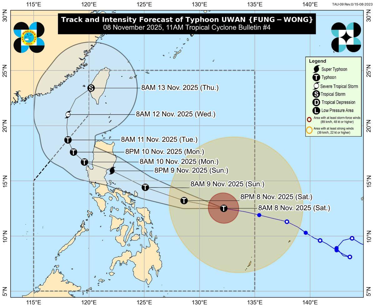
PAGASA warned that heavy rainfall, severe winds, and storm surges may still be experienced in localities far from the landfall point and outside the forecast confidence cone. It added that the track may still shift within the limit of the forecast confidence cone.
Based on PAGASA’s track and intensity outlook, Uwan was forecast to move west northwestward on Saturday and Sunday (9 November) before turning generally more northwestward on Monday (10 November).
According to the track forecast, the center of Uwan's eye may pass close to Catanduanes on Sunday morning and make landfall over the southern portion of Isabela or the northern portion of Aurora on Sunday (09 November) evening or Monday early morning.
Uwan's center was estimated based on all available data at 680 km east of Borongan City, Eastern Samar or 760 km east of Catarman, Northern Samar (12.6 °N, 131.6 °E).
Moving westward at 35 kph, it has maximum sustained winds of 140 kph near the center and gusts of up to 170 kph.
"Furthermore, there is also an increasing possibility of a slight southward shift in the projected path of UWAN, which may result to a direct hit (i.e., eyewall affecting the area without making landfall) or a landfall scenario over Catanduanes," PAGASA said.
"UWAN is forecast to rapidly intensify and may reach super typhoon category tonight (Saturday) or tomorrow (Sunday), although the potential for a much faster intensification is not ruled out due to favorable environment. It may also make landfall at or near its peak lifetime intensity. The interaction with the terrain will cause UWAN to weaken, but it is expected to remain as a typhoon throughout its passage over Northern Luzon and West Philippine Sea," it added. — VDV, GMA Integrated News
