

5 areas under Signal No. 3 as Uwan strengthens near PH Sea
Signal No. 3 has been raised over five areas in Luzon and the Visayas as Typhoon Uwan continues to strengthen near the Philippine Sea.
According to PAGASA’s 5 p.m. Saturday cyclone bulletin, the following areas under Signal No. 3 may experience storm-force winds of 89 km/h to 117 km/h.
- Catanduanes
- the eastern portion of Camarines Sur (Siruma, Tinambac, Goa, Lagonoy, Caramoan, Tigaon, Garchitorena, Sagñay, San Jose, Presentacion)
- the eastern portion of Albay (Tiwi, Santo Domingo, Malinao, Rapu-Rapu, City of Tabaco, Bacacay, Malilipot)
- the northeastern portion of Sorsogon (Prieto Diaz)
- the northeastern portion of Northern Samar (Palapag, Mapanas, Laoang)
The following areas under Signal No. 2 may expect winds of 62 km/h to 88 km/h:
- the eastern portion of mainland Cagayan
- Isabela
- Quirino
- Nueva Vizcaya
- Aurora
- Nueva Ecija
- Bulacan
- Metro Manila
- Rizal
- Laguna
- Quezon
- Marinduque
- Camarines Norte
- the rest of Camarines Sur
- the rest of Albay
- the rest of Sorsogon
- Burias Island
- Ticao Island
- the rest of Northern Samar
- the northern portion of Samar (Matuguinao, San Jose de Buan, Calbayog City, Tagapul-An, Santo Niño, Almagro, San Jorge, San Sebastian, Jiabong, Pagsanghan, City of Catbalogan, Gandara, Motiong, Santa Margarita, Tarangnan, Paranas, Hinabangan)
- the northern portion of Eastern Samar (Maslog, San Policarpo, Dolores, Jipapad, Oras, Arteche, Can-Avid, City of Borongan, Taft, Sulat, San Julian, Maydolong)
The following areas under Signal No. 1 may experience winds of 39 km/h to 61 km/h:
- Batanes
- the rest of Cagayan including Babuyan Islands
- Apayao
- Abra
- Kalinga
- Mountain Province
- Ifugao
- Benguet
- Ilocos Norte
- Ilocos Sur
- La Union
- Pangasinan
- Tarlac
- Pampanga
- Zambales
- Bataan
- Cavite
- Batangas
- the rest of Masbate
- Romblon
- Oriental Mindoro
- Occidental Mindoro including Lubang Islands
- Calamian Islands
- Cuyo Islands
- the rest of Samar
- the rest of Eastern Samar
- Biliran
- Leyte
- Southern Leyte
- Bohol
- the northern and central portions of Cebu (Medellin, Daanbantayan, City of Bogo, Tabogon, San Remigio, Tabuelan, Borbon, Sogod, Tuburan, Catmon, Carmen, Danao City, Compostela, Liloan, Consolacion, Lapu-Lapu City, Mandaue City, Cordova, Asturias, Cebu City, Balamban, City of Talisay, Toledo City, Minglanilla, Dumanjug, Argao, Sibonga, Barili, Ronda, Moalboal, Badian, Dalaguete, Alcantara, City of Carcar, City of Naga, San Fernando, Pinamungahan, Aloguinsan) including Bantayan and Camotes Islands
- the northern portion of Negros Occidental (City of Escalante, Toboso, Sagay City, Cadiz City, Calatrava, Manapla, City of Victorias, Enrique B. Magalona, Silay City, City of Talisay, San Carlos City, Salvador Benedicto, Murcia, Bacolod City, Hinigaran, City of Himamaylan, Binalbagan, Isabela, Moises Padilla, La Castellana, Pontevedra, San Enrique, La Carlota City, Bago City, Valladolid, Pulupandan)
- the northern portion of Negros Oriental (Canlaon City, Jimalalud, La Libertad, Tayasan, Vallehermoso, City of Guihulngan)
- Guimaras
- Iloilo
- Capiz
- Aklan
- Antique
- Dinagat Islands
- Surigao del Norte
- the northern portion of Agusan del Norte (Tubay, Santiago, Jabonga, Kitcharao)
- the northern portion of Surigao del Sur (Carrascal, Cantilan, Madrid, Carmen, Lanuza, Cortes)
“The wind signals warn the public of the general wind threat over an area due to the tropical cyclone. Local winds may be slightly stronger/enhanced in coastal and upland/mountainous areas exposed to winds. Winds are less strong in areas sheltered from the prevailing wind direction,” PAGASA said.
The highest possible wind signal that may be raised remains at Signal No. 5.
Areas not under any wind signals may still experience occasionally gusty conditions reaching strong to gale-force strength.
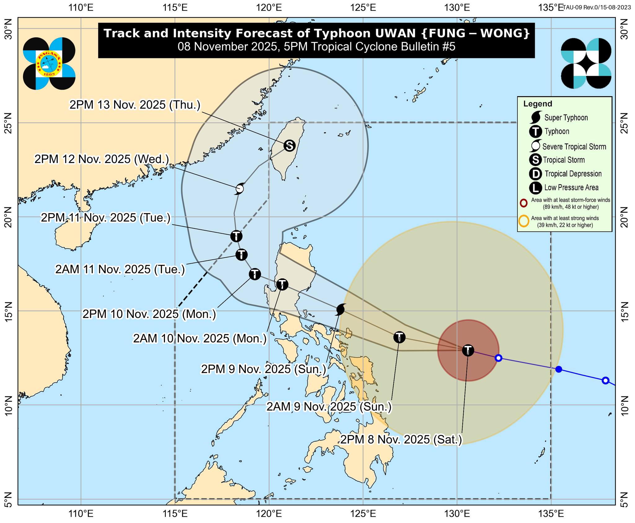
As of 4 p.m., Uwan was seen 575 km east of Catarman, Northern Samar or 620 km east of Virac, Catanduanes, with maximum sustained winds of 150 km/h and gustiness of up to 185 km/h.
Uwan was moving west northwestward at 30 km/h.
PAGASA warned about a possible storm surge with peak heights exceeding 3.0 meters within the next 48 hours in Batanes, Cagayan, Isabela, Ilocos Norte, Ilocos Sur, La Union, Pangasinan, Aurora, Zambales, Bataan, Pampanga, Bulacan, Metro Manila, Cavite, Batangas, Quezon, Camarines Norte, Camarines Sur, Catanduanes, Albay, Sorsogon, Northern Samar, Eastern Samar, Dinagat Islands, and Siargao and Bucas Grande Islands.
A gale warning has been placed over the northern, eastern, and southern seaboards of Luzon, the eastern and central seaboards of Visayas, and the eastern seaboard of Mindanao.
“Heavy rainfall, severe winds, and storm surge may still be experienced in localities far from the landfall point and outside the forecast confidence cone,” said PAGASA.
A landfall scenario may take place in the southern portion of Isabela or the northern portion of Aurora by Sunday evening or early Monday morning, while a possible slight southward shift in tracks may also lead to a direct hit or landfall over Catanduanes.
Uwan is predicted to rapidly intensify into a super typhoon category by Saturday night or Sunday, but favorable environments may cause faster intensification and landfall scenarios during or near its peak lifetime intensity. —VBL, GMA Integrated News
