

Five areas under Signal No. 5 as Uwan maintains strength
Tropical Cyclone Wind Signal No. 5 was raised over five areas as Super Typhoon Uwan maintained its strength, PAGASA said Sunday morning.
Based on PAGASA’s 11 a.m. cyclone bulletin, the following areas are under TCWS No. 5:
- the central portion of Aurora (San Luis, Baler, Maria Aurora, Dipaculao);
- Polillo Islands;
- the northern portion of Camarines Norte (Daet, Talisay, Paracale, Vinzons, Jose Panganiban, Mercedes, Basud);
- the eastern portion of Camarines Sur (Siruma, Caramoan, Garchitorena, Tinambac, Lagonoy); and
- Catanduanes.
TCWS No. 4 was hoisted over the following areas:
- the southern portion of Isabela (San Agustin, Jones, Echague, Dinapigue, San Guillermo);
- Quirino;
- the eastern portion of Nueva Vizcaya (Dupax del Sur, Dupax del Norte, Alfonso Castañeda, Kasibu);
- the rest of Aurora;
- Nueva Ecija;
- the easternmost portion of Pampanga (Candaba);
- the northern and eastern portion of Bulacan (Doña Remedios Trinidad, San Miguel, San Ildefonso, Norzagaray, San Rafael);
- the northern and eastern portions of Quezon (Tagkawayan, Calauag, Guinayangan, Perez, Alabat, Quezon, Infanta, General Nakar, Real);
- the rest of Camarines Norte;
- the rest of Camarines Sur; and
- the northeastern portion of Albay (Rapu-Rapu, Bacacay, City of Tabaco, Malilipot, Malinao, Tiwi, Polangui).
The following areas meanwhile are under TCWS No. 3:
- The southern portion of mainland Cagayan (Tuao, Enrile, Solana, Tuguegarao City, Peñablanca, Iguig, Piat, Amulung);
- The rest of Isabela;
- The rest of Nueva Vizcaya;
- The southern portion of Apayao (Conner);
- Kalinga;
- Abra;
- Mountain Province;
- Ifugao;
- Benguet;
- Ilocos Sur;
- La Union;
- Pangasinan;
- Zambales;
- Bataan;
- Tarlac;
- The rest of Pampanga;
- The rest of Bulacan;
- Metro Manila;
- Cavite;
- Batangas;
- Rizal;
- Laguna;
- The rest of Quezon;
- Marinduque;
- The rest of Albay;
- Sorsogon;
- Ticao;
- Burias Islands; and
- Northern Samar.
TCWS No. 2 was hoisted over the following areas:
- The rest of Cagayan including Babuyan Islands;
- The rest of Apayao;
- Ilocos Norte;
- Occidental Mindoro including Lubang Islands;
- Oriental Mindoro;
- Romblon;
- The rest of Masbate;
- Eastern Samar;
- Samar;
- Biliran; and
- The northern and central portions of Leyte (Leyte, Calubian, San Isidro, Tabango, Capoocan, Carigara, Barugo, San Miguel, Babatngon, Tacloban City, Alangalang, Tunga, Palo, Santa Fe, Pastrana, Matag-Ob, Tolosa, Mayorga, Julita, Dagami, Jaro, Villaba, La Paz, Tabontabon, Tanauan, Ormoc City, Dulag, Burauen, Kananga, Albuera, Palompon, Merida, Isabel).
The following areas meanwhile are under TCWS No. 1:
- Batanes;
- Calamian Islands;
- Cuyo Islands;
- The rest of Leyte;
- Southern Leyte;
- Bohol;
- The northern and central portions of Cebu (Medellin, Daanbantayan, City of Bogo, Tabogon, San Remigio, Tabuelan, Borbon, Sogod, Tuburan, Catmon, Carmen, Danao City, Compostela, Liloan, Consolacion, Lapu-Lapu City, Mandaue City, Cordova, Asturias, Cebu City, Balamban, City of Talisay, Toledo City, Minglanilla, Dumanjug, Argao, Sibonga, Barili, Ronda, Moalboal, Badian, Dalaguete, Alcantara, City of Carcar, City of Naga, San Fernando, Pinamungahan, Aloguinsan) including Bantayan and Camotes Islands;
- The northern and central portions of Negros Occidental (City of Escalante, Toboso, Sagay City, Cadiz City, Calatrava, Manapla, City of Victorias, Enrique B. Magalona, Silay City, City of Talisay, San Carlos City, Salvador Benedicto, Murcia, Bacolod City, Hinigaran, City of Himamaylan, Binalbagan, Isabela, Moises Padilla, La Castellana, Pontevedra, San Enrique, La Carlota City, Bago City, Valladolid, Pulupandan);
- The northern portion of Negros Oriental (Canlaon City, Jimalalud, La Libertad, Tayasan, Vallehermoso, City of Guihulngan);
- Guimaras;
- Iloilo;
- Capiz;
- Aklan;
- Antique;
- Dinagat Islands;
- Surigao del Norte;
- The northern portion of Agusan del Norte (Tubay, Santiago, Jabonga, Kitcharao); and
- The northern portion of Surigao del Sur (Carrascal, Cantilan, Madrid, Carmen, Lanuza, Cortes).
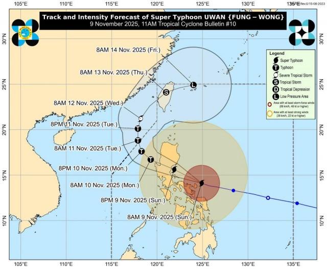
At 10 a.m., Uwan was last located over the coastal waters of Pandan, Catanduanes, carrying maximum sustained winds of 185 km/h near the center and gusts of up to 230 km/h, and is moving west northwestward at 30 km/h.
Winds
“The wind signals warn the public of the general wind threat over an area due to the tropical cyclone,” PAGASA said.
“Local winds may be slightly stronger/enhanced in coastal and upland/mountainous areas exposed to winds. Winds are less strong in areas sheltered from the prevailing wind direction,” it added.
The state weather bureau maintained that on Sunday, Uwan will bring occasionally gusty conditions reaching strong to gale-force strength over Palawan, Visayas, and Mindanao, which are not under any wind signal.
Storm surge
Within the next 48 hours, a high risk of life-threatening and damaging storm surge with peak heights exceeding 3.0 meters is expected over the low-lying or exposed coastal communities of Cagayan, Isabela, Ilocos Norte, Ilocos Sur, La Union, Pangasinan, Aurora, Zambales, Bataan, Pampanga, Bulacan, Metro Manila, Cavite, Batangas, Quezon, Camarines Norte, Camarines Sur, Catanduanes, Albay, Sorsogon, Northern Samar, Eastern Samar, Dinagat Islands, and Siargao and Bucas Grande Islands.
A gale warning is also in effect over the seaboards of Luzon, the eastern and central seaboards of Visayas, and the eastern seaboards of Mindanao.
Track
PAGASA said heavy rainfall, severe winds, and storm surge may still be experienced far from the landfall point or center track and even in areas outside the forecast confidence cone.
“Do not focus on the center track as it may still shift within the limit of the forecast confidence cone,” state meteorologists said.
The storm is expected to move west northwestward over the next 24 hours.
Meanwhile, the center of the eye of Uwan will continue to move over the coastal waters of Catanduanes, pass close to Calaguas and Polillo Islands this morning and afternoon, respectively.
It will then make landfall at or near its peak intensity over the central portion of Aurora on Sunday evening or early Monday morning.
“Due to its proximity, a direct hit (i.e., eyewall affecting the area without making landfall) over Calaguas and Polillo Islands is possible,” PAGASA said.
After landfall, Uwan is expected to traverse the mountainous terrain of Northern Luzon and emerge over Lingayen Gulf or the coastal waters of Pangasinan or La Union on Monday morning.
“The interaction with the terrain will cause Uwan to weaken significantly, but it is expected to remain as typhoon throughout its passage over Northern Luzon,” it added.
“Uwan will begin to turn northwestward to northward from tomorrow to Tuesday (11 November) while remaining at typhoon category,” it added.
The storm is then expected to turn northeastward towards the Taiwan Strait while weakening on Wednesday.
“It is forecast to make landfall over western Taiwan on Thursday (13 November), then rapidly weaken over the Taiwan landmass before emerging over the waters near Ryukyu Islands as a remnant low or weak tropical depression,” PAGASA said.
Classes, gov't work, flights
Malacañang on Sunday announced the suspension of government work in nine regions on November 10 and classes in 12 regions on November 10 to 11 in light of the impact of Super Typhoon Uwan (international name: Fung-Wong).
Several flights for Nov. 9 and 10 were also canceled. —KG, GMA Integrated News
