

Signal No. 5 in 4 areas as Uwan nears landfall in Aurora
Signal No. 5 has been hoisted over four areas in Luzon as Super Typhoon Uwan nears landfall over central or northern Aurora, PAGASA said Sunday.
In its 8 p.m. tropical cyclone bulletin, the state weather bureau said that Tropical Cyclone Wind Signal (TCWS) No. 5 is over:
- The southern portion of Quirino (Nagtipunan),
- the southeastern portion of Nueva Vizcaya (Alfonso Castañeda, Dupax del Norte, Dupax del Sur),
- the northeastern portion of Nueva Ecija (Bongabon, Carranglan, Pantabangan), and
- the northern and central portion of Aurora (San Luis, Baler, Maria Aurora, Dipaculao, Dinalungan, Casiguran)
In these areas, typhoon-force winds 185 km/h or higher (Beaufort 12) could pose an "extreme threat" to life and property, PAGASA said.
Signal No. 4 is over 17 areas:
- The southern portion of Isabela (San Agustin, Jones, Echague, Dinapigue, San Guillermo, Cordon, City of Santiago, Ramon, San Isidro, Angadanan),
- the rest of Quirino,
- the rest of Nueva Vizcaya,
- the southern portion of Mountain Province (Tadian, Bauko, Sabangan),
- the southern portion of Ifugao (Tinoc, Asipulo, Lamut, Kiangan, Lagawe, Hingyon, Hungduan),
- Benguet,
- the southern portion of Ilocos Sur (Sugpon, Alilem, Cervantes, City of Candon, Santa Lucia, Suyo, Sigay, Galimuyod, Tagudin, Santa Cruz, Salcedo, San Esteban, Santiago),
- La Union,
- Pangasinan,
- the rest of Aurora,
- the rest of Nueva Ecija,
- the northernmost portion of Zambales (Santa Cruz),
- the northeastern portion of Tarlac (Camiling, San Clemente, Paniqui, Gerona, Victoria, Pura, Ramos, Moncada, San Manuel, Anao, La Paz, City of Tarlac, Santa Ignacia),
- the easternmost portion of Pampanga (Candaba),
- the eastern portion of Bulacan (Doña Remedios Trinidad, San Miguel, San Ildefonso, Norzagaray, San Rafael),
- the northern portion of Rizal (Rodriguez), and
- the northern portion of Quezon (Infanta, General Nakar, Real) including Polillo Islands
Signal No. 3 is over:
- The southern portion of mainland Cagayan (Tuao, Enrile, Solana, Tuguegarao City, Peñablanca, Iguig, Piat, Amulung, Santo Niño, Alcala, Rizal),
- the rest of Isabela,
- the northwestern, central, and southern portions of Apayao (Conner, Kabugao, Calanasan),
- Abra,
- Kalinga,
- the rest of Mountain Province,
- the rest of Ifugao,
- Ilocos Norte,
- the rest of Ilocos Sur,
- the rest of Zambales,
- Bataan,
- the rest of Tarlac,
- the rest of Pampanga,
- the rest of Bulacan,
- Metro Manila,
- Cavite,
- Batangas,
- the rest of Rizal,
- Laguna,
- the rest of Quezon,
- Marinduque,
- Camarines Norte,
- Camarines Sur, and
- Catanduanes
Signal No. 2 is over:
- Babuyan Islands,
- the rest of mainland Cagayan,
- the rest of Apayao,
- Occidental Mindoro,
- Oriental Mindoro,
- Romblon,
- Albay,
- Sorsogon, and
- the northern and western portions of Masbate (City of Masbate, Mobo, Aroroy, Balud, Mandaon, Milagros, Baleno, Uson) including Ticao and Burias Islands
Signal No. 1 is over everal areas in Luzon and in Visayas:
- Batanes,
- the rest of Masbate, and
- the northern portion of Palawan (Taytay, Dumaran, El Nido, Araceli, Roxas, San Vicente) including Calamian, Cuyo, and Cagayancillo Islands
- Northern Samar,
- Eastern Samar,
- Samar,
- Biliran,
- Leyte,
- Southern Leyte,
- Bohol,
- Cebu,
- Siquijor,
- Negros Oriental,
- Negros Occidental,
- Guimaras,
- Iloilo,
- Capiz,
- Aklan, and
- Antique
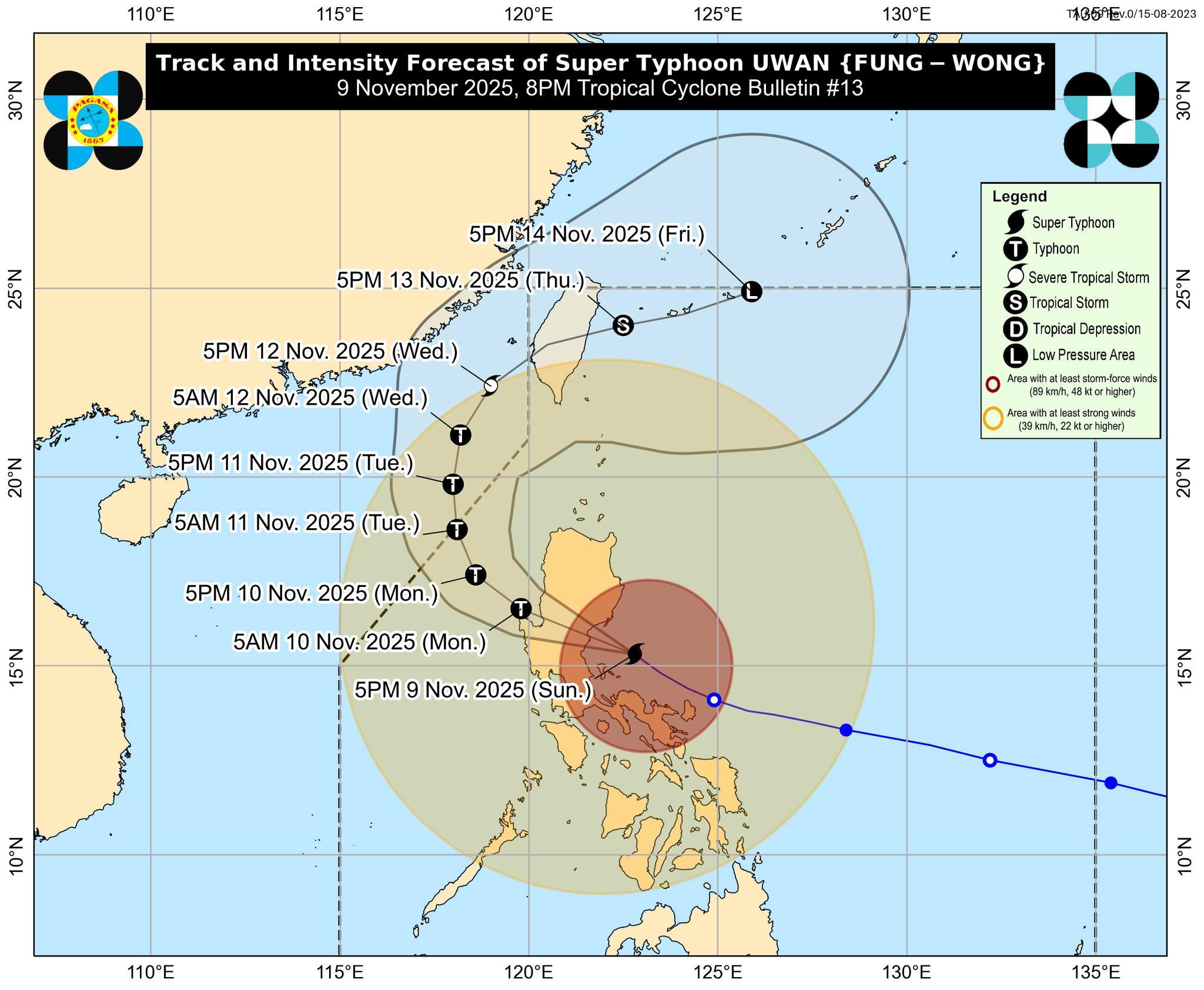
Uwan nears landfall
According to the state weather bureau, Uwan will continue to move west-northwest over the next 24 hours and may make landfall "at or near its peak intensity (e.g., as a super typhoon or an upper limit of typhoon)" over Aurora—anywhere along the coastline from Baler to Casiguran—Sunday night or early Monday morning.
"After landfall, Uwan will traverse the mountainous terrain of Northern Luzon and emerge over Lingayen Gulf or the coastal waters of Pangasinan or La Union tomorrow morning. The interaction with the terrain will cause Uwan to weaken significantly, but it is expected to remain as typhoon throughout its passage over Northern Luzon," PAGASA added.
Very rough, high, or very high seas are expected in several areas, particularly in the seaboards of Isabela, Aurora, and Camarines Norte and the northern and eastern seaboard of Polillo Islands, where up to 14 meters of waves are expected.
Effects
The death toll due to the weather has now risen to at least two, with one person dead reported in Catanduanes and an earlier fatality reported in Catbalogan, Samar.
Classes for Monday have also been suspended across several regions due to the super typhoon, as well as some sea trips, and some bus trips at the PITX. — BM, GMA Integrated News
