

PAGASA: Signal No. 4 up in 15 areas as Uwan crosses Luzon
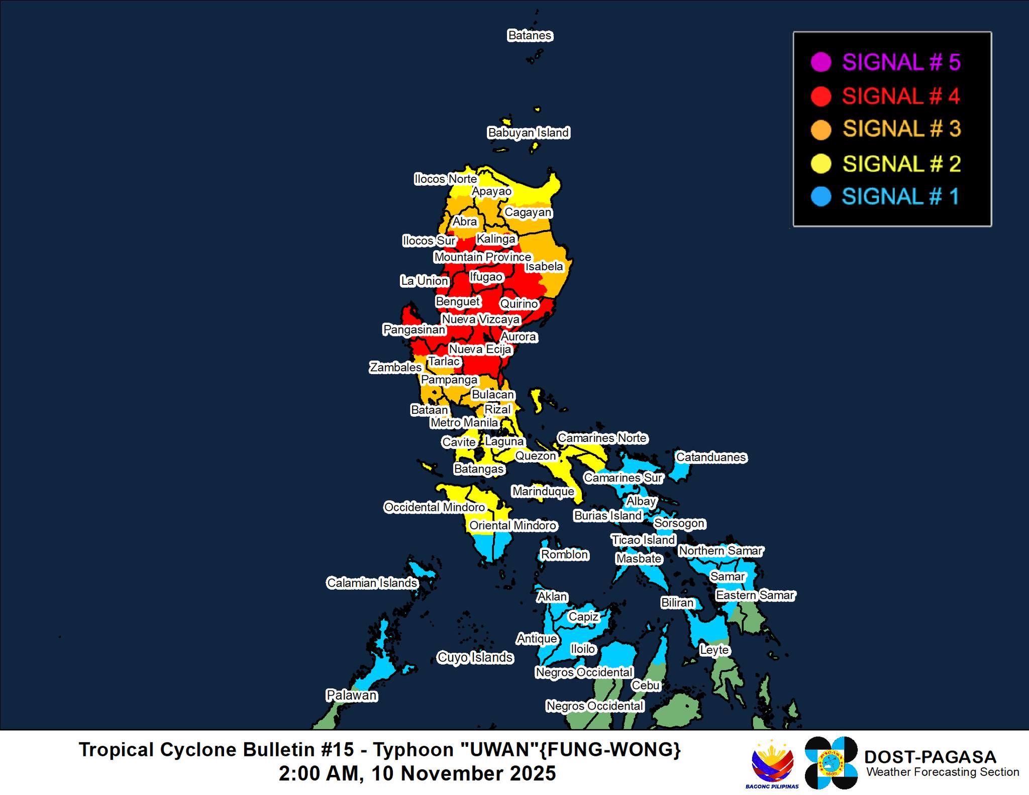
Super Typhoon Uwan has now weakened into a typhoon with Signal No. 4, as the highest tropical cyclone warning signal hoisted over 15 areas in Northern and Central Luzon, the state weather bureau said early Monday morning.
In its 2 a.m. tropical cyclone bulletin, PAGASA said the center of the eye of Uwan was in the vicinity of Bagulin, La Union as of 1 a.m. Monday and is still moving northwestward at 30 km/h with maximum sustained winds of 165 km/h near the center, gustiness of up to 275 km/h, and central pressure of 945 hPa.
The highest tropical cyclone warning signal in effect is now Signal No. 4. The tropical warning signals are as follows:
Signal No. 4
- The southwestern portion of Isabela (Cordon, City of Santiago, Echague, Jones, San Agustin, San Guillermo, San Isidro, Alicia, Angadanan, Ramon, San Mateo, City of Cauayan, Benito Soliven, Naguilian, Reina Mercedes, Luna, Cabatuan, Aurora, San Manuel, Roxas, Mallig, Quirino, Burgos, Gamu, Quezon)
- Quirino
- Nueva Vizcaya
- The southern portion of Kalinga (City of Tabuk, Tanudan, Tinglayan, Pasil, Lubuagan)
- Mountain Province
- The southern portion of Abra (Tubo, Luba, Boliney, Villaviciosa, Pilar, Daguioman, Bucloc, Manabo, San Isidro, San Quintin, Pidigan)
- Ifugao
- Benguet
- The central and southern portions of Ilocos Sur (Narvacan, Nagbukel, Santa Maria, Burgos, San Esteban, Santiago, Banayoyo, Lidlidda, San Emilio, Quirino, Cervantes, Gregorio del Pilar, Sigay, Suyo, Alilem, Salcedo, Galimuyod, City of Candon, Santa Lucia, Santa Cruz, Tagudin, Sugpon)
- La Union
- Pangasinan
- Aurora
- Nueva Ecija
- The northern and eastern portions of Tarlac (Concepcion, La Paz, Victoria, City of Tarlac, Gerona, Pura, Ramos, Paniqui, Anao, San Manuel, Moncada, Camiling, San Clemente, Santa Ignacia, Mayantoc), and
- The northern portion of Zambales (Santa Cruz, Candelaria).
Signal No. 3
- The central and southern portions of mainland Cagayan (Rizal, Santo Niño, Alcala, Baggao, Peñablanca, Amulung, Iguig, Tuguegarao City, Solana, Tuao, Piat, Enrile)
- The rest of Isabela, the southern portion of Apayao (Pudtol, Kabugao, Conner)
- The rest of Kalinga
- The rest of Abra
- The southern portion of Ilocos Norte (Nueva Era, Solsona, Dingras, Marcos, Banna, City of Batac, Paoay, Currimao, Pinili, Badoc)
- The rest of Ilocos Sur
- Bulacan
- Pampanga
- The rest of Tarlac
- The rest of Zambales
- Bataan
- The northern portion of Metro Manila (Caloocan City, Quezon City, City of Marikina, City of Valenzuela, City of Malabon, City of Navotas)
- The northern and eastern portions of Rizal (Rodriguez, San Mateo, Tanay, City of Antipolo), and
- The northern portion of Quezon (General Nakar).
Signal No. 2
- The rest of Apayao
- The rest of Ilocos Norte
- The rest of Quezon including Polillo Islands
- The rest of Metro Manila
- The rest of Rizal
- Laguna
- Cavite
- Batangas
- Marinduque
- The northern portion of Oriental Mindoro (Pola, Naujan, City of Calapan, Victoria, Baco, Puerto Galera, San Teodoro, Socorro, Pinamalayan, Gloria)
- The northern and central portions of Occidental Mindoro (Abra de Ilog, Paluan, Mamburao, Santa Cruz, Sablayan) including Lubang Islands
- Camarines Norte
- The northwestern portion of Camarines Sur (Del Gallego, Ragay, Lupi, Sipocot), and
- The rest of mainland Cagayan including Babuyan Islands.
Signal No. 1
Luzon:
- Batanes
- The northern portion of Palawan (Taytay, Dumaran, El Nido, Araceli, Roxas, San Vicente) including Calamian Islands, Cuyo Islands, and Cagayancillo Islands
- The rest of Camarines Sur
- Catanduanes
- Albay
- Sorsogon
- Masbate including Ticao and Burias Islands
- Romblon
- The rest of Oriental Mindoro, and
- The rest of Occidental Mindoro.
Visayas:
- Northern Samar
- The northern and central portions of Samar (San Jorge, Matuguinao, Almagro, Calbayog City, Jiabong, Pagsanghan, City of Catbalogan, Gandara, Motiong, Santo Niño, Tagapul-An, San Jose de Buan, Santa Margarita, Tarangnan, Paranas, Hinabangan, San Sebastian, Calbiga, Pinabacdao, Villareal, Daram, Zumarraga, Talalora, Santa Rita)
- The northern portion of Eastern Samar (Can-Avid, Maslog, San Policarpo, Taft, Dolores, Jipapad, Oras, Arteche, Sulat)
- The northern portion of Leyte (Tunga, Pastrana, San Miguel, Matag-Ob, Palo, Calubian, Leyte, Carigara, Babatngon, Dagami, Jaro, San Isidro, Santa Fe, Villaba, Palompon, Tabontabon, Tanauan, Merida, Ormoc City, Isabel, Capoocan, Alangalang, Tabango, Tacloban City, Kananga, Barugo)
- Biliran
- The northern portion of Cebu (Medellin, Daanbantayan, City of Bogo, Tabogon, San Remigio, Tabuelan, Borbon, Sogod, Tuburan, Catmon) including Bantayan Islands
- Guimaras
- The northern portion of Negros Occidental (City of Escalante, Toboso, Sagay City, Cadiz City, Calatrava, Manapla, City of Victorias, Enrique B. Magalona, Silay City, City of Talisay, Salvador Benedicto, Murcia, Bacolod City, Bago City, Valladolid, Pulupandan, San Carlos City)
- Iloilo
- Capiz
- Aklan, and
- Antique including Caluya Islands.
PAGASA also issued a new storm surge warning for low-lying and exposed coastal communities in Ilocos Region, Cagayan Valley, Central Luzon, Metro Manila, CALABARZON, most of MIMAROPA, Camarines Norte, Camarines Sur, Catanduanes, Masbate including Burias Island, Aklan, Antique, Guimaras, Negros Occidental, Negros Oriental that may be hit with storm surges exceeding heights of three meters.
Earlier, Uwan made landfall over Dinalungan, Aurora at 9:10 p.m. Sunday night.
The state weather bureau said the typhoon will emerge over La Union’s coastal waters on Monday morning and will maintain its strength over the West Philippine Sea until Tuesday, November 11.
Uwan will begin to turn northwestward to northward from Monday until Tuesday while remaining at typhoon category, and will turn northeastward towards the Taiwan Strait on Wednesday.
“It is forecast to make landfall over western Taiwan on Thursday (13 November), then rapidly weaken over the Taiwan landmass before emerging over the waters near Ryukyu Islands before weakening further into a remnant low,” PAGASA said.
However, the state weather bureau warned that “heavy rainfall, severe winds, and storm surge may still be experienced far from the landfall point or center track, and even in areas outside the forecast confidence cone.” — JMA, GMA Integrated News
