

How high up your leg is 200 mm of rain? PAGASA shows
With tropical cyclone Uwan reaching typhoon status even before making landfall in Luzon over the weekend, the weather bureau PAGASA warned of rainfall of as much as 200 mm over a huge portion of the island.
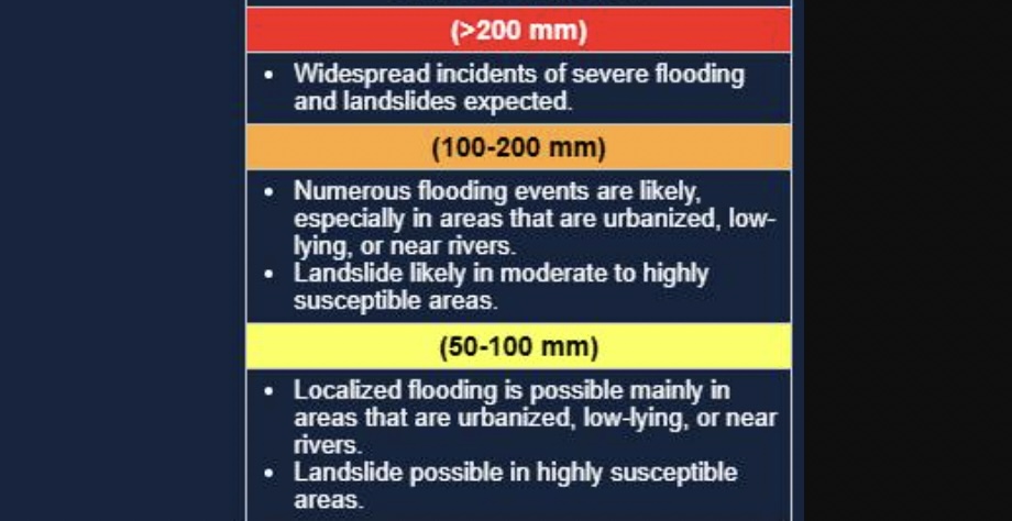
It also warned of rainfall between 50 mm to 100 mm and 100 mm to 200 mm in other parts of the archipelago.
With rain gauges not a normal fixture in Filipino households, how much is 200 mm of rain in more common terms?
According to PAGASA Climate Monitoring and Prediction Section chief Ana Liza Solis, explained that 1 mm of rain is equivalent to one liter of rain poured onto a square meter of flat surface.
“200 mm means 200 liters ibinuhos mo sa one square meter na flat surface,” Solis told GMA News Online.
200 bottles of a one-liter soft drink
To give a better picture, PAGASA weather specialist John Manalo said 200 mm of rainwater is as much as 200 bottles of a 1-liter soft drink.
“Hanggang lagpas ng papunta sa binti mo bago magtuhod. Ganun kataas na tubig ‘yan,” Manalo told GMA News Online.
(Up to past your lower leg, before your knee. That's how high the water is.)
“Ilang bote ng Coke? 200 na bote ng Coke….na 1 liter. At dapat i-bubuhos mo siya doon sa area na 1 cubic liter, para makuha ko yung representative,” he added.
(How many bottles of Coke? 200 bottles of 1-liter Coke. And you should pour it over an area of 1 cubic liter, so I can get the representative [volume].)
The latest rainfall advisory on Monday night showed that Benguet is expected to experience 100 to 200 millimeters of rain until Tuesday afternoon, November 11. Floodings are also expected in urbanized and low-lying areas, and landslides are likely to occur in susceptible areas.
Fifty to 100 mm of rain is expected over Ilocos Norte, Ilocos Sur, La Union, Pangasinan, Abra, Zambales, Bataan, and Occidental Mindoro until Tuesday afternoon.
How flooding becomes severe
When asked why 200 millimeters of rainfall could lead to flooding despite being only knee-deep, the state weather bureau said that landmass comes into the picture.
"'Yung hanggang tuhod is visual representation lang siya kung gano'n kataas," PAGASA weather specialist Chenel Dominguez told GMA News Online.
(The knee-high level is just a visual representation of the height.)
"Pero ite-take consideration po natin kung gaano po ba kalaki po yung kalupaan po na itong probinsya na ito. At yun po, yun po yung hanggang tuhod po," she added. "Pag pinagsamang-sama naman po natin kahit hanggang tuhod po yun, marami din po yung aabot din po ng 50 to 100, above 100 or above 200 din po."
(But we will take into consideration how large the land area of that province is. And that, that's the knee-high part. When we combine all of it, even if it's only knee-high, many areas will still reach 50 to 100 mm, above 100 or even above 200 [millimeters of rain].)
PAGASA explained that the amount of rainfall depends on the movement of the storm.
“Well, depende sa bagyo e, at saka doon sa kaulapan na associated sa kanya. At sa case nitong si Uwan, dahil bumilis yung pagkilos nito., umabot ng 30 to 35 kilometers per hour, mabilis ‘yun para sa bagyo. Kaya hindi tayo nababad sa ulan nung pagdaan niya,” Manalo said.
(Well, it depends on the typhoon, and the clouds associated with it. And in the case of Uwan, because its movement sped up, reaching 30 to 35 kilometers per hour, that's fast for a typhoon. That's why we weren't soaked in the rain when it passed.)
“‘Pag bumagal naman yung bagyo, doon naman tayo nababad dahil sa kaulapan na nandun sa bagyo, bubuhos nang bubuhos ‘yan lalo na dun sa tinatawag natin na rainbands.”
(When the typhoon slows down, that's when we get soaked because the clouds in the typhoon will keep pouring, especially in what we call the rainbands.)
Imagine the hazards
Further, PAGASA said that the best way to depict or visualize the amount of rainfall is by the hazards it can cause.
“So more on hazards po talaga sinasabi po namin na ganito po, nagko-cause po ng mga pagbaha, nagko-cause ng mga pagguho ng lupa," said Dominguez.
(So we're really focusing more on the hazards when we explain this, [that] it causes floods, [that] it causes landslides.)
As of 5 p.m., only Tropical Cyclone Wind Signal No. 2 is raised over several areas in Luzon.
PAGASA said that Uwan is forecast to exit the Philippine Area of Responsibility (PAR) tonight or early tomorrow morning. It may re-enter PAR on Wednesday evening as it makes landfall over the southwestern coast of Taiwan, resulting in further weakening. –NB, GMA Integrated News
