

13 areas under Signal No. 1 as Wilma moves over Philippine Sea
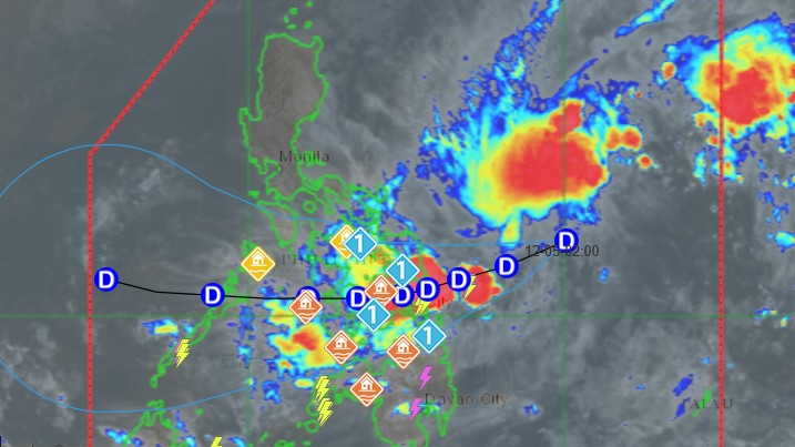
Tropical Cyclone Wind Signal No. 1 has been hoisted in more areas, including those in Luzon, as Tropical Depression Wilma decelerated while moving over the Philippine Sea east of Northern Samar.
According to the 5 p.m. weather bulletin by PAGASA, the following areas are under Signal No. 1:
Luzon
- The southern portion of mainland Masbate (Cataingan, Pio V. Corpuz, Esperanza, Placer)
Visayas
- Northern Samar
- Eastern Samar
- Samar
- Biliran
- Leyte
- Southern Leyte
- The northern portion of Cebu (Daanbantayan, Medellin, City of Bogo, San Remigio, Tabogon, Borbon, Tabuelan, Tuburan, Sogod, Catmon, Asturias, Carmen, Danao City, Balamban, Compostela, Liloan, Consolacion, Cebu City, Mandaue City, Cordova, Lapu-Lapu City) including Bantayan and Camotes Islands
- The eastern and central portions of Bohol (Inabanga, Sagbayan, Carmen, Garcia Hernandez, Jagna, Sierra Bullones, Pilar, Duero, Guindulman, Anda, Candijay, Mabini, Alicia, Ubay, Pres. Carlos P. Garcia, San Miguel, Dagohoy, Danao, Buenavista, Getafe, Trinidad, Talibon, Bien Unido)
Mindanao
- Surigao del Norte including Siargao and Bucas Grande Islands
- Dinagat Islands
- The northern portion of Surigao del Sur (Carrascal, Cantilan, Madrid, Carmen)
- The northern portion of Agusan del Norte (Kitcharao, Jabonga, Santiago, Tubay, City of Cabadbaran
PAGASA said Wilma was last monitored 575 kilometers east of Catarman, Northern Samar. It packs maximum sustained winds of 45 kilometers per hour near the center and gustiness of up to 55 kilometers per hour.
The tropical cyclone is currently moving west southwestward at 10 kmh with central pressure as 1,004 hpa, the state weather bureau added.
State meteorologists said that Wilma is forecast to make its initial landfall in Eastern Visayas or Dinagat Islands between Friday evening, December 5 and Saturday morning, December 6.
“On the forecast track, the center of WILMA may make its initial landfall in Eastern Visayas or Dinagat Islands between tomorrow (05 December) evening and Saturday morning. Afterwards, it will continue to traverse Visayas until Sunday (07 December). It will then emerge over Sulu Sea and may pass over northern Palawan between Sunday evening and Monday (08 December) morning,” said PAGASA.
While Wilma is expected to slightly intensify before landfall, PAGASA said that it will likely remain a tropical depression throughout the forecast period.
Further, PAGASA warned of 100 to 200 millimeters of rain from Thursday to Friday afternoon over Northern Samar, Eastern Samar, Samar, and Biliran.
Meanwhile, 50 to 100 millimeters of rain is expected over Leyte, Southern Leyte, Cebu, Bohol, Negros Oriental, Negros Occidental, Siquijor, Surigao del Norte, Dinagat Islands, Agusan del Norte, Misamis Oriental and Camiguin during the said period.
According to its 24-hour weather forecast, the state weather bureau said that Wilma may bring rains with gusty winds over Eastern Visayas, Surigao del Norte, and Dinagat Islands.
The tropical depression is also forecast to bring cloudy skies with scattered rains and thunderstorms over northern Mindanao, the rest of Visayas, the rest of Caraga, and Zamboanga del Norte. —Vince Angelo Ferreras/RF, GMA Integrated News
